- Investigating the Impact of Habitat Fragmentation on Woodland Caribou (Rangifer Tarandus) in British Columbia
Woodland caribou populations in British Columbia are in steep decline despite extensive intervention efforts by the BC and Canadian Governments. The main drivers behind woodland caribou decline are habitat loss and increased predation. Caribou rely on large, contiguous tracts of mature forest to forage for lichens in the winter, raise their young in the spring, and as protection from predation.
- Applying a Faster R-CNN Model Coupled with a Generalized Linear Model to Optical Imagery to Fill Population Data Gaps in Villages along the Southwest Coast of Madagascar
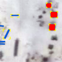
Arid, infertile soil within the southwest of Madagascar creates poor agricultural conditions that have worsened over the years due to climate change. Coastal areas are experiencing rapid population growth due to the allure of marine resources for economic support and food security. However, there exists large uncertainty surrounding how many people rely on these marine resources. As a result, bottom-up management systems have been implemented to mitigate data paucity related to population and marine resource management. This study outlines a methodology for predicting population of coastal villages via detection of artisanal fishing boats, known as pirogues, and houses from the RGB bands in high resolution satellite imagery from Maxar Technologies using a Faster Regions with Convolutional Neural Networks (Faster R-CNN) detection model and a generalized linear model.
- Promoting human-wildlife coexistence through ecological connectivity modelling on the University of British Columbia Vancouver campus
Abstract Urban landscape networks of connected habitat nodes are expanding and play an important role in shaping the biosphere. Within these networks, humans and wildlife coexist, living and moving in close proximity with the potential for conflict. Remotely sensed data provides accurate knowledge of landscape cover. Circuit-based ecological connectivity models can simulate the movement of…
Read more: Promoting human-wildlife coexistence through ecological connectivity modelling on the University of British Columbia Vancouver campus
- Visualize Six Years of Architectural Changes at the University of British Columbia Vancouver Campus: Impacts on Tree Growth, Green Connectivity, and Coyote Footprints
Abstract Urban development, such as campus expansion, alters land cover and disrupts ecological processes, but the full extent of these impacts is often underexamined at fine spatial and temporal scales. This study investigates how building expansion on the University of British Columbia (UBC) Vancouver campus from 2015 to 2021 has influenced tree dynamics and coyote…
Read more: Visualize Six Years of Architectural Changes at the University of British Columbia Vancouver Campus: Impacts on Tree Growth, Green Connectivity, and Coyote Footprints
- Integrating LiDAR (Light Detection and Ranging) and Camera Traps to Assess the Influence of Three-Dimensional Forest Structure on Mammal Habitat Use in Coastal Western Hemlock Forests
Abstract Global forest degradation and habitat loss caused have induced the need for advanced methods to assess forest quality and how would these change impacts on animals. Although extensive research has focused on responses of birds to habitat change, the influence of forest structure on mammals has remained underexplored. In southwestern British Columbia, Malcolm Knapp…
Read more: Integrating LiDAR (Light Detection and Ranging) and Camera Traps to Assess the Influence of Three-Dimensional Forest Structure on Mammal Habitat Use in Coastal Western Hemlock Forests
- Assessing the Impact of the University of British Columbia Campus Vision 2050 on Eastern Grey Squirrel Habitat Suitability in Acadia Park
Abstract Urban development is a leading driver of habitat fragmentation, with significant implications for wildlife in growing cities. This research investigates how projected urban expansion under the University of British Columbia’s Campus Vision 2050 may impact Eastern Grey Squirrel habitat suitability in Acadia Park, a residential neighborhood on the University of British Columbia Vancouver campus.…
Read more: Assessing the Impact of the University of British Columbia Campus Vision 2050 on Eastern Grey Squirrel Habitat Suitability in Acadia Park
- Distribution of Berries in response to climate change
Abstract Climate change and greenhouse gas emissions are among the most serious issues worldwide, significantly impacting biodiversity and food security. In Canada, berries such as the Saskatoon berry and Red Huckleberry hold considerable cultural, economic, and ecological value. This study evaluates the potential impact of climate change on the future distribution of these two berry…
Read more: Distribution of Berries in response to climate change
- Ecological Connectivity Through UBC – An Omniscape Approach
Abstract Human activities and rapid urbanization have led to habitat destruction and fragmentation, severely impacting biodiversity and ecosystem services globally. This study focuses on the UBC campus, surrounded by the Pacific Spirit Regional Park, to assess and enhance ecological connectivity through the urban landscape. Using advanced remote sensing techniques, including Planet SkySat satellite imagery and…
Read more: Ecological Connectivity Through UBC – An Omniscape Approach
- Functional Habitat Connectivity Analysis for the Township of Langley, British Columbia
This study aimed to assess the functional habitat connectivity of the Township of Langley in British Columbia, Canada, to facilitate urban planning and biodiversity conservation. Using lidar-derived and land cover data, habitat connectivity was quantified with the probability of connectivity index (PC) for three species (the western red-backed salamander, the American red squirrel, and the brown creeper) with different habitat requirements and mobility. Suitable habitat patches were filtered and selected based on the habitat requirements of each species; Habitat networks were generated considering dispersal distance to model the connectivity index in the Conefor software. The study found a large variance in PC and distribution of important patches among species in the landscape. The major connectivity corridor, identified according to the distribution of key-hub patches for all species, showed some important areas for overall connectivity improvement. This study enhances understanding of local-scale connectivity and offers guidance for biodiversity conservation in decision-making. The study also highlights potential areas for habitat preservation, which is particularly relevant for urban green infrastructure design that supports both human well-being and biodiversity conservation.
- Habitat Connectivity of Coyotes and Brown Creepers at the University of British Columbia Campus in Canada
Habitat fragmentation has become an increasing threat to biodiversity. To address this problem, landscape connectivity modelling has become a popular method for identifying key areas for conservation efforts. This study assessed the habitat connectivity of two species, coyotes (Canis latrans) and brown creepers (Certhia americana), on UBC Vancouver campus using Conefor 2.6 and Conefor Inputs Tool. The land cover and Metro Vancouver data were used to identify habitat types and patch sizes needed by each species. Key and hub patches for each species were identified using spatial prioritization and evaluated their connectivity using the probability of connectivity (PC) values. The results showed that both species shared some important areas of connectivity, but brown creepers had a more connected network, while coyotes had higher key and hub
patches. Areas of high and low connectivity for each species were also found to be affected by factors such as buildings and proximity to green spaces. The study highlights the importance of considering the specific habitat requirements of different species in conservation efforts and emphasizes the need to prioritize the conservation of key and hub patches for maintaining habitat connectivity and ensuring the survival of multiple species.
- Habitat Connectivity Using Conefor 2.6 For Salt Spring Island In British Columbia
Habitat connectivity is fundamental for animal species dispersal and gene flow. This study analyzed habitat connectivity on Salt Spring Island, British Columbia, from the perspective of the brown creeper bird, the red squirrel, and the red-legged frog. The research objectives were: assessing network connectivity; identifying the most important habitat patches; and identifying the most important disturbed areas for restoration. The methods included: creating habitat patches and links based on specific habitat requirements using the Landsat landcover classes and Light Detection and Ranging data; assigning a quality to each land use category to calculate the area-weighted quality of each patch; and performing the connectivity analysis in Conefor 2.6 using the Probability of Connectivity index and its associated metrics. The results suggest that all habitats may require restoration, but efforts may be focus on the frog since it is significantly less connected. The best way to enhance the species survival and dispersal rate may be to buffer existing patches with woodland, and develop corridors and hub patches that are large and rich in resources to provide both more connectivity and more habitat.
- Regional Habitat Suitability for the Ronald Lake Bison Herd: An investigation of the spatial relationship between the Ronald Lake Bison Herd and the Athabasca River in Northeast Alberta, Canada
Wood bison (Bison bison athabascae) are a cultural keystone species for the many Indigenous peoples. The herd is located in the northeastern region of Alberta, Canada and is constrained by the Athabasca River on the eastern extent of their range. This project has woven Mikisew Cree Indigenous knowledge and western scientific methods together to understand potential constraining factors that have limited the eastern progression of the Ronald Lake Bison Herd (RLBH). Background research into wood bison behavior resulted in the Athabasca River being unlikely to be a large factor into why the herd does not cross the river. As a result, the study pivoted to focus on the habitat suitability of the broader herd location. Suitable habitat attributes had been identified by Mikisew Cree traditional ecological knowledge (TEK) and were used to guide the analysis. This study supports the broader conservation and management efforts for the RLBH through encouraging the protection of their existing range area, since no other habitat in the area was able to meet or exceed the habitability of their current location. Additionally, this project contributes to the existing body of knowledge that demonstrates the importance of incorporating Indigenous knowledge systems into wildlife research and management.
- Predicting Forage Availability from Open Source LiDAR Data
Livestock forage availability is an important factor when allocating land for grazing animals. Due to the variation in British Columbia’s topography and plant communities, rangeland management faces unique challenges with natural resource operations and rural development. The goal of this study was to create a predictive model of forage availability using light detection and ranging (LiDAR) data from the Open LiDAR Data Portal and biometric ground truthing data from the Vegetation Resource Index.
- Pollinators Habitat Capability Analysis of the University of British Columbia (UBC) Vancouver Campus
Pollination is an essential ecosystem service for crop production, where species such as insects and birds help to transfer pollen for plants to reproduce. Many of the pollinators are fully dependent on the plants and trees as their food sources and habitat. From a perspective of an urban planner, we must be able to recognize the values brought by pollinators to our ecosystems. Thus, we are attempting to discover the relationship between species and their habitats as much as possible.
- Distribution of suitable habitat in winter and summer for plains bison (Bison bison bison) in the Pink Mountain Region of British Columbia
The plains bison (Bison bison bison) is threatened in Canada, with the biggest threat to their recovery being a lack of habitat in which they are considered compatible. Although the Pink Mountain, British Columbia, bison herd currently has about 1,000 individuals, there has never been a formal study of the suitability of the area to sustain the herd. Therefore, this study was performed to determine if the Pink Mountain region contains plains bison suitable habitat based on guiding principles for developing a Habitat Suitability Index.
 Arid, infertile soil within the southwest of Madagascar creates poor agricultural conditions that have worsened over the years due to climate change. Coastal areas are experiencing rapid population growth due to the allure of marine resources for economic support and food security. However, there exists large uncertainty surrounding how many people rely on these marine resources. As a result, bottom-up management systems have been implemented to mitigate data paucity related to population and marine resource management. This study outlines a methodology for predicting population of coastal villages via detection of artisanal fishing boats, known as pirogues, and houses from the RGB bands in high resolution satellite imagery from Maxar Technologies using a Faster Regions with Convolutional Neural Networks (Faster R-CNN) detection model and a generalized linear model.
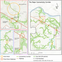 This study aimed to assess the functional habitat connectivity of the Township of Langley in British Columbia, Canada, to facilitate urban planning and biodiversity conservation. Using lidar-derived and land cover data, habitat connectivity was quantified with the probability of connectivity index (PC) for three species (the western red-backed salamander, the American red squirrel, and the brown creeper) with different habitat requirements and mobility. Suitable habitat patches were filtered and selected based on the habitat requirements of each species; Habitat networks were generated considering dispersal distance to model the connectivity index in the Conefor software. The study found a large variance in PC and distribution of important patches among species in the landscape. The major connectivity corridor, identified according to the distribution of key-hub patches for all species, showed some important areas for overall connectivity improvement. This study enhances understanding of local-scale connectivity and offers guidance for biodiversity conservation in decision-making. The study also highlights potential areas for habitat preservation, which is particularly relevant for urban green infrastructure design that supports both human well-being and biodiversity conservation.
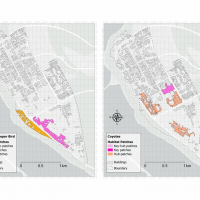 Habitat fragmentation has become an increasing threat to biodiversity. To address this problem, landscape connectivity modelling has become a popular method for identifying key areas for conservation efforts. This study assessed the habitat connectivity of two species, coyotes (Canis latrans) and brown creepers (Certhia americana), on UBC Vancouver campus using Conefor 2.6 and Conefor Inputs Tool. The land cover and Metro Vancouver data were used to identify habitat types and patch sizes needed by each species. Key and hub patches for each species were identified using spatial prioritization and evaluated their connectivity using the probability of connectivity (PC) values. The results showed that both species shared some important areas of connectivity, but brown creepers had a more connected network, while coyotes had higher key and hub patches. Areas of high and low connectivity for each species were also found to be affected by factors such as buildings and proximity to green spaces. The study highlights the importance of considering the specific habitat requirements of different species in conservation efforts and emphasizes the need to prioritize the conservation of key and hub patches for maintaining habitat connectivity and ensuring the survival of multiple species.
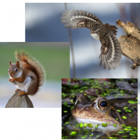 Habitat connectivity is fundamental for animal species dispersal and gene flow. This study analyzed habitat connectivity on Salt Spring Island, British Columbia, from the perspective of the brown creeper bird, the red squirrel, and the red-legged frog. The research objectives were: assessing network connectivity; identifying the most important habitat patches; and identifying the most important disturbed areas for restoration. The methods included: creating habitat patches and links based on specific habitat requirements using the Landsat landcover classes and Light Detection and Ranging data; assigning a quality to each land use category to calculate the area-weighted quality of each patch; and performing the connectivity analysis in Conefor 2.6 using the Probability of Connectivity index and its associated metrics. The results suggest that all habitats may require restoration, but efforts may be focus on the frog since it is significantly less connected. The best way to enhance the species survival and dispersal rate may be to buffer existing patches with woodland, and develop corridors and hub patches that are large and rich in resources to provide both more connectivity and more habitat.
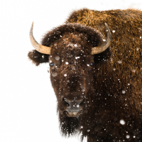 Wood bison (Bison bison athabascae) are a cultural keystone species for the many Indigenous peoples. The herd is located in the northeastern region of Alberta, Canada and is constrained by the Athabasca River on the eastern extent of their range. This project has woven Mikisew Cree Indigenous knowledge and western scientific methods together to understand potential constraining factors that have limited the eastern progression of the Ronald Lake Bison Herd (RLBH). Background research into wood bison behavior resulted in the Athabasca River being unlikely to be a large factor into why the herd does not cross the river. As a result, the study pivoted to focus on the habitat suitability of the broader herd location. Suitable habitat attributes had been identified by Mikisew Cree traditional ecological knowledge (TEK) and were used to guide the analysis. This study supports the broader conservation and management efforts for the RLBH through encouraging the protection of their existing range area, since no other habitat in the area was able to meet or exceed the habitability of their current location. Additionally, this project contributes to the existing body of knowledge that demonstrates the importance of incorporating Indigenous knowledge systems into wildlife research and management.
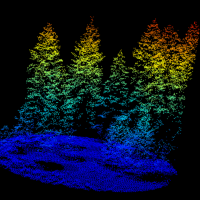 Livestock forage availability is an important factor when allocating land for grazing animals. Due to the variation in British Columbia’s topography and plant communities, rangeland management faces unique challenges with natural resource operations and rural development. The goal of this study was to create a predictive model of forage availability using light detection and ranging (LiDAR) data from the Open LiDAR Data Portal and biometric ground truthing data from the Vegetation Resource Index.
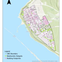 Pollination is an essential ecosystem service for crop production, where species such as insects and birds help to transfer pollen for plants to reproduce. Many of the pollinators are fully dependent on the plants and trees as their food sources and habitat. From a perspective of an urban planner, we must be able to recognize the values brought by pollinators to our ecosystems. Thus, we are attempting to discover the relationship between species and their habitats as much as possible.
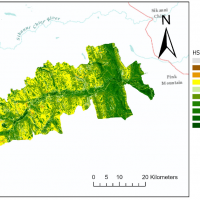 The plains bison (Bison bison bison) is threatened in Canada, with the biggest threat to their recovery being a lack of habitat in which they are considered compatible. Although the Pink Mountain, British Columbia, bison herd currently has about 1,000 individuals, there has never been a formal study of the suitability of the area to sustain the herd. Therefore, this study was performed to determine if the Pink Mountain region contains plains bison suitable habitat based on guiding principles for developing a Habitat Suitability Index.