- Detecting Change of Aboveground Biomass (AGB) in Kwahu South, Ghana
Abstract Forest plays a vital role in regulating the global carbon cycle, yet their aboveground biomass (AGB) remains difficult to estimate over large areas due to limitations of field-based measurements. This study addresses the challenge by evaluating satellite-based approaches to estimate AGB in Kwahu South, Ghana. The objective was to determine which optical satellite imagery,…
Read more: Detecting Change of Aboveground Biomass (AGB) in Kwahu South, Ghana
- Energy Consumption Comparison Between Electric Vehicles and Internal Combustion Vehicles Traveling Between Horseshoe Bay and Whistler with BEVER Tool
Abstract The transportation sector is a major contributor to global greenhouse gas emissions, prompting a growing shift toward electric vehicles (EVs) as a climate mitigation strategy. EVs are known for their efficiency, but how they perform in hilly or mountainous terrain highway still needs closer study. This study investigates the energy consumption and cost efficiency…
Read more: Energy Consumption Comparison Between Electric Vehicles and Internal Combustion Vehicles Traveling Between Horseshoe Bay and Whistler with BEVER Tool
- Estimating Above-Ground Biomass Using Remote Sensing and Machine Learning in Kwahu South, Ghana
Abstract Tropical forests in regions like Kwahu South, Ghana, are vital for mitigating climate change by storing carbon in aboveground biomass (AGB), but deforestation and land use changes, driven by agriculture and mining, threaten their role as carbon sinks. Accurate AGB estimation is crucial for conservation and sustainable land management, yet traditional field methods are…
Read more: Estimating Above-Ground Biomass Using Remote Sensing and Machine Learning in Kwahu South, Ghana
- Comparison of Methods of Multi-Source Remote Sensing Estimations of Aboveground Biomass of Tropical Rainforests in Kwahu South, Ghana
Abstract Aboveground biomass (AGB) is an important metric in forest carbon analysis, allowing for continuous monitoring of changes in biomass over time. Field measurements to provide accurate assessments of these metrics are cost and time-prohibitive, although remote sensing can gather this information quickly and more affordably, and with machine learning models they can achieve robust…
Read more: Comparison of Methods of Multi-Source Remote Sensing Estimations of Aboveground Biomass of Tropical Rainforests in Kwahu South, Ghana
- Replication Data for: Evaluating Carbon Baselines in Kwahu South: A Comparison of VM0047 and Open Forest Protocol
Abstract Forests are essential for climate change mitigation, acting as carbon sinks by absorbing carbon dioxide. Remote sensing, particularly through Landsat 8’s 30m resolution imagery, facilitates consistent, large-scale monitoring of forest cover and biomass changes, crucial for precise carbon stock assessments in reforestation efforts. However, differences in baseline estimation methodologies complicate these evaluations. This study…
Read more: Replication Data for: Evaluating Carbon Baselines in Kwahu South: A Comparison of VM0047 and Open Forest Protocol
- Assessing Baseline and Monitoring Change in Forest Carbon Projects
Abstract This study evaluates carbon stock changes in the Northern Scarp West Forest Reserve (project site) and Bumfuom Forest Reserve (control site) in Ghana, using remote sensing techniques and biomass estimation methodologies. The aim is to compare two carbon crediting frameworks Gold Standard V2.1 and Verra VM0047 in terms of their effectiveness in monitoring carbon…
Read more: Assessing Baseline and Monitoring Change in Forest Carbon Projects
- Using LiDAR-based Inventories to Evaluate the Impact of Silvicultural Practices on Forest Biomass
Abstract Forests are crucial in absorbing and storing carbon in land-based ecosystems, and their proper management is essential for mitigating climate change. This study assesses the influence of silvicultural systems on the amount of forest carbon in the Boundary Timber Supply Area (TSA) located in BC. The evaluation is based on enhanced forest inventories conducted…
Read more: Using LiDAR-based Inventories to Evaluate the Impact of Silvicultural Practices on Forest Biomass
- Evaluating the Above-Ground Carbon Storage of Urban Trees on University of British Columbia Vancouver Campus
Urban forestry is a crucial tool for mitigating the impacts of climate change and enhancing people’s quality of life. Previous studies have shown that urban forests provide a wide range of ecosystem services. However, precise estimation of urban tree carbon storage remains a key challenge for effective urban forest management and planning. In this work, we investigated the carbon storage of trees on the UBC Vancouver Campus using 2018 LiDAR data. The aim was to determine the total carbon storage and the average carbon density of UBC campus. Tree height and structure were estimated using an existing model. The results revealed that the UBC Vancouver Campus has a total carbon storage of 24.63 Gg and an average carbon density of 6.13 kg m-2. These findings emphasize the significant role urban forests play in climate change mitigation and urban life improvement. Employing LiDAR data in conjunction with the existing model proved to be an efficient and effective method for estimating urban tree carbon storage. The results inform urban planning and policy decisions, fostering the integration of urban forests into sustainable campus development.
- Comparing the Level of Carbon Sequestration Capability of Different Soft Landscape in UBC
This study investigated the carbon sequestration rates of soft landscapes in the University of British Columbia Vancouver campus and compare their carbon sequestration capacity. The significance of carbon sequestration rates in soft landscapes is discussed in the context of urban planning and the role of vegetation in mitigating climate change. LiDAR data and aerial photos are used to estimate above-ground carbon sequestration, and GIS and R are used for data analysis. The research objectives are to compare the attributes of different soft landscapes, estimate their carbon sequestration rates, identify which soft landscapes have the highest carbon sequestration capacity, and discuss the limitations of the study and possible improvements for future research. The study aims to provide insights for optimizing urban soft landscape services to increase carbon storage in cities, and to explore the potential for incorporating soft landscapes as a sustainable urban infrastructure for carbon sequestration. Moreover, the findings may inform decisions regarding the implementation of sustainable landscape design of new and existing urban green spaces.
- Comparing the Level of Above-ground Carbon Sequestration and Respective Ecosystem Services between Native and Cultivated Trees in the University of British Columbia Botanical Garden
Urban trees play an essential role in alleviating the local effects of global warming by sequestering atmospheric carbon dioxide, regulating temperature and reducing air pollution in urban areas. There have been studies estimating carbon sequestration of urban trees using Light Detection and Ranging (LiDAR). Yet, neither of the studies made comparison between species nor extended the discussion towards ecosystem services. Therefore, this study compared the attributes between native and cultivated trees in the Asian Garden of the University of British Columbia (UBC) Botanical Garden, estimated their level of above-ground carbon sequestration, and thus examined respective implications in terms of ecosystem services.
- Using SAR Imagery to Assess Forest Distribution on a Cloudy Tropical Island
Tropical forests experience some of the highest rates of deforestation in the world. Accurate mapping and monitoring of the forest is required to mitigate this deforestation, which is complicated in tropical forests due to the high frequency of cloud cover. Synthetic aperture radar (SAR) imagery can overcome this challenge by seeing through the clouds. However, the historical lack of freely available SAR imagery means its role in characterizing forest cover is less developed than that of optical imagery. This study aimed to compare freely available SAR imagery with freely available optical imagery in order to characterize the forest cover of a particularly cloudy, mountainous tropical forest in the Philippines.
- How does vegetation fragmentation affect urban carbon stock in City of Vancouver, Canada
Urban vegetation acts as an extremely important carbon stock to store carbon. Although many studies have investigated the relationship between urban vegetation and carbon stocks, few of them closely examine the phenomenon of vegetation fragmentation in urban areas and how it affects the carbon stock. Therefore, this project investigates how vegetation fragmentation affects carbon stocks in the City of Vancouver using GIS analytic tools.
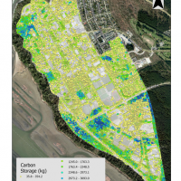
- Mapping ‘Blue Carbon’ in Cambodian Mangroves: A Case Study Analysis for the Koh Rong Archipelago
Mangrove forests, and other coastal ecosystems, are recognized for their role in climate change mitigation due to their significant potential for carbon storage and carbon sequestration. These ecosystems are some of the most threatened ecosystems on earth and are at risk of loss and degradation because of anthropogenic activities. Carbon financing mechanisms offer a way to help implement, finance and support the conservation and restoration of coastal ecosystems.
 Urban forestry is a crucial tool for mitigating the impacts of climate change and enhancing people’s quality of life. Previous studies have shown that urban forests provide a wide range of ecosystem services. However, precise estimation of urban tree carbon storage remains a key challenge for effective urban forest management and planning. In this work, we investigated the carbon storage of trees on the UBC Vancouver Campus using 2018 LiDAR data. The aim was to determine the total carbon storage and the average carbon density of UBC campus. Tree height and structure were estimated using an existing model. The results revealed that the UBC Vancouver Campus has a total carbon storage of 24.63 Gg and an average carbon density of 6.13 kg m-2. These findings emphasize the significant role urban forests play in climate change mitigation and urban life improvement. Employing LiDAR data in conjunction with the existing model proved to be an efficient and effective method for estimating urban tree carbon storage. The results inform urban planning and policy decisions, fostering the integration of urban forests into sustainable campus development.
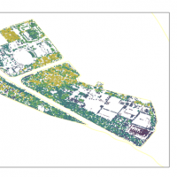 This study investigated the carbon sequestration rates of soft landscapes in the University of British Columbia Vancouver campus and compare their carbon sequestration capacity. The significance of carbon sequestration rates in soft landscapes is discussed in the context of urban planning and the role of vegetation in mitigating climate change. LiDAR data and aerial photos are used to estimate above-ground carbon sequestration, and GIS and R are used for data analysis. The research objectives are to compare the attributes of different soft landscapes, estimate their carbon sequestration rates, identify which soft landscapes have the highest carbon sequestration capacity, and discuss the limitations of the study and possible improvements for future research. The study aims to provide insights for optimizing urban soft landscape services to increase carbon storage in cities, and to explore the potential for incorporating soft landscapes as a sustainable urban infrastructure for carbon sequestration. Moreover, the findings may inform decisions regarding the implementation of sustainable landscape design of new and existing urban green spaces.
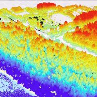 Urban trees play an essential role in alleviating the local effects of global warming by sequestering atmospheric carbon dioxide, regulating temperature and reducing air pollution in urban areas. There have been studies estimating carbon sequestration of urban trees using Light Detection and Ranging (LiDAR). Yet, neither of the studies made comparison between species nor extended the discussion towards ecosystem services. Therefore, this study compared the attributes between native and cultivated trees in the Asian Garden of the University of British Columbia (UBC) Botanical Garden, estimated their level of above-ground carbon sequestration, and thus examined respective implications in terms of ecosystem services.
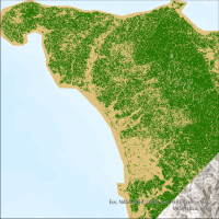 Tropical forests experience some of the highest rates of deforestation in the world. Accurate mapping and monitoring of the forest is required to mitigate this deforestation, which is complicated in tropical forests due to the high frequency of cloud cover. Synthetic aperture radar (SAR) imagery can overcome this challenge by seeing through the clouds. However, the historical lack of freely available SAR imagery means its role in characterizing forest cover is less developed than that of optical imagery. This study aimed to compare freely available SAR imagery with freely available optical imagery in order to characterize the forest cover of a particularly cloudy, mountainous tropical forest in the Philippines.
 Urban vegetation acts as an extremely important carbon stock to store carbon. Although many studies have investigated the relationship between urban vegetation and carbon stocks, few of them closely examine the phenomenon of vegetation fragmentation in urban areas and how it affects the carbon stock. Therefore, this project investigates how vegetation fragmentation affects carbon stocks in the City of Vancouver using GIS analytic tools.
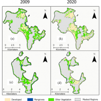 Mangrove forests, and other coastal ecosystems, are recognized for their role in climate change mitigation due to their significant potential for carbon storage and carbon sequestration. These ecosystems are some of the most threatened ecosystems on earth and are at risk of loss and degradation because of anthropogenic activities. Carbon financing mechanisms offer a way to help implement, finance and support the conservation and restoration of coastal ecosystems.