- Post-Fire Mortality and Fire Resistance of Old-growth Forests in the Kootenay Lake Timber Supply Area, British Columbia
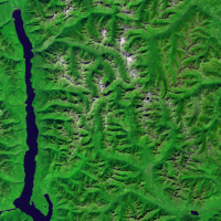
In an era of climate change, how different tree species in old forests are disturbed by wildfires, and what fire resistance they have are important questions. Old-growth forests are significant because they maintain local biodiversity and ecosystem sustainability, and also contribute to the local economy through timber harvesting. In this research, by analyzing Landsat-8 images of 20 fires from 2016 to 2020, the disturbance data of the forest before and after the fire can be generated. Data from B.C. government and Landsat-8 images are used to analyze fire resistance and recovery of old-growth forests in the Kootenay Lake Timber Supply Area (TSA) by calculating NBR (Normalized burn ratio) and NDVI (Normalized Difference Vegetation Index).
- The Effects of Fuel Type Map Accuracy on Fire Behaviour Metrics
For fire managers and industry professionals, monitoring and leading wildfire prevention efforts as well as reactionary efforts require accurate and operable fuel type maps to achieve effective management. Fuel type map classification accuracy has been seen to have varying values across industries and applications (> 10 %), and the consequences of these misclassifications in fuel type mapping has yet to be determined. The objective of this research was to explore the effects of mapping error on fire behavior metrics, burn probability, fire intensity, and rate of spread in the southern interior forest region of British Columbia which experiences dry weather and extreme fire conditions.
- Detection and Monitoring of Wildfire-Induced Earthflows: InSAR Time Series Analysis in the Deadman River Watershed, British Columbia
Abstract This research investigates the efficiency of Interferometric Synthetic Aperture Radar (InSAR) in identifying and tracking changes in earthflow activity and movement post wildfire. The study was conducted in British Columbia’s Deadman River Watershed, which was severely impacted by the Sparks Lake wildfire in 2021, increasing the possibility of landslide reactivation and movement. Using InSARderived…
Read more: Detection and Monitoring of Wildfire-Induced Earthflows: InSAR Time Series Analysis in the Deadman River Watershed, British Columbia
- Modelling the Effects of Timber Harvest and Harvest Site Selection on Burn Probability
Abstract Climate change exacerbates wildfire risks globally, with projections indicating a significant increase in their frequency and severity. This study investigates the impact of timber harvesting on wildfire likelihood, focusing on the Mount Rose Swanson Sensitive Area (RSSA) in British Columbia, Canada. Using the Burn-P3 model, three scenarios were simulated: no harvest, harvest in high…
Read more: Modelling the Effects of Timber Harvest and Harvest Site Selection on Burn Probability
- Tracking Forest Recovery: Early Indicators of Forest Regeneration Following the 2017 Elephant Hill Wildfire in British Columbia, Canada
Abstract Wildfire is an increasingly prominent disturbance across forested landscapes in British Columbia, yet ecological responses and long-term vegetation recovery remain complex and spatially variable. This study investigates post-fire vegetation recovery following the 2017 Elephant Hill wildfire using Landsat-derived remote sensing data from 2015 to 2022. By analyzing the Normalized Burn Ratio (NBR) and Normalized…
Read more: Tracking Forest Recovery: Early Indicators of Forest Regeneration Following the 2017 Elephant Hill Wildfire in British Columbia, Canada
- Influence of Aspen Serpentine Leafminer (Phyllocnistis populiella) on Burn Severity In Trembling Aspen (Populus tremuloides)
Abstract Trembling aspen (Populus tremuloides) is a fire-resilient tree species, making its role increasingly important as wildfire seasons intensify in British Columbia, Canada. However, forest pests like the aspen serpentine leafminer (Phyllocnistis populiella) raise concerns about their potential to alter fire behavior by affecting forest structure and fuel conditions. This study evaluates whether leafminer outbreaks…
Read more: Influence of Aspen Serpentine Leafminer (Phyllocnistis populiella) on Burn Severity In Trembling Aspen (Populus tremuloides)
- Evaluating LiDAR technology to Augment Fuel Typing Classification by Enhancing accuracy of Vegetation Resource Indices in The Resort Municipality of Whistler
Abstract This study evaluates the integration of airborne LiDAR (Light Detection and Ranging) data with British Columbia’s Vegetation Resource Inventory (VRI) to identify opportunities for enhancement. LiDAR-derived forest structure metrics were compared against VRI estimates in the Resort Municipality of Whistler, revealing discrepancies and variable correlation strengths. Tree height showed a moderately strong correlation (r…
Read more: Evaluating LiDAR technology to Augment Fuel Typing Classification by Enhancing accuracy of Vegetation Resource Indices in The Resort Municipality of Whistler
- Deriving airborne LiDAR metrics to estimate ladder fuel density in Whistler, British Columbia
Abstract With increasing wildfire frequency and severity, understanding ladder fuels—vegetation structures facilitating fire propagation from forest floors to canopies—is crucial for effective wildfire management. Active remote sensors, such as light detection and ranging (LiDAR), are able to penetrate the forest canopy and allow for the characterization of understory vegetation structures. This study investigates the use…
Read more: Deriving airborne LiDAR metrics to estimate ladder fuel density in Whistler, British Columbia
- The Relationship between Land Surface Temperature Anomalies and Fire Occurrence in Cariboo Region in 2017
Abstract Wildfires can disrupt forest ecosystem, leading to a deterioration of the air quality, and loss of resources, property animals and people. Understanding the driving factors and the spatial distribution of wildfire benefits local forest fire management planning and resource allocation for fire suppression. To analyze how the land surface temperature (LST) anomaly is related…
Read more: The Relationship between Land Surface Temperature Anomalies and Fire Occurrence in Cariboo Region in 2017
- Deriving LiDAR Metrics for Forest Structure Mapping in Wildfire Risk Assessment
Abstract The escalating incidents of wildfire pose a critical challenge in Canada, necessitating an understanding of forest structures for the effective implementation of fuel treatment strategies to mitigate wildfire risks. While previous research has explored forest structures and wildfire risk, a gap remains in translating these studies into operational solutions for foresters and land managers.…
Read more: Deriving LiDAR Metrics for Forest Structure Mapping in Wildfire Risk Assessment
- Using Remote Sensing Data and Raster Analysis Tools to Assess Fire Hazard Severity in South-Central British Columbia
The Penticton region of British Columbia, Canada is an area which is experiencing increasingly worsening wildfire events. These natural disturbances represent a significant threat to local ecosystems, property and human life and wellbeing. Landscape analysis of fire hazard levels is necessary to direct emergency service management prior to and during wildfire events and to inform policy on how to manage these natural disasters. To assess fire hazard levels, a GIS-based multi-criteria analysis was performed to understand fire hazard spatially, subdivided into low, moderate, high, and severe hazard areas. Two models were built to achieve this, taking into account commonly used variables employed to assess fire hazard severity around the world. To identify potential differences in hazard assessment, the models weighted these variables differently from one another. Fire location points from the year 2000 to 2021 were overlayed with each respective model output. Model 1 spatially overlapped with 73.88% of these fires, while model 2 spatially overlapped with 74.35%. These results can help identify areas of elevated hazard under ideal burning conditions, inform deployment of emergency services and resources, and provide a framework for using a GIS to conduct a fire hazard landscape assessment.
- Metrics of Change: Informing Ecological Restoration by Quantifying Landscapes and Processes in Banff National Park
The landscapes in the Rocky Mountain Cordillera undergo constant change due to the intricate interplay of ecological processes, with fire being the primary disturbance agent. Fire suppression policies have impeded the ecological role of fire, resulting in increased conifer forest dominance and declines in landscape heterogeneity. The objective of this study was to develop a methodology to accurately measure regional landscape changes resulting from fire suppression and fire restoration in Banff National Park, with the goal of supporting data-informed resource management. A landscape metrics approach was selected to investigate changes across 27 management units. Four landscape metrics were calculated using annual land cover maps derived from Virtual Land Cover Engine/Landsat-5/7 imagery spanning 34 years (1984-2019). Metrics were selected to capture conifer encroachment (proportion of conifer class) and landscape heterogeneity (contagion, edge density, Shannon’s diversity index) changes. Time-series analysis and Thiel-Sen slope estimation were used to identify metric trends. The study’s resulting metrics offer resource managers additional landscape attributes to compare and monitor management units, which can support decision-making, prioritize fire restoration and inform future ecological studies.
- Burn-P3 modelling of fire behaivour on Rose Swanson Mountain, British Columbia before and after harvesting
It has been long known that wildfire and harvesting can have a relationship. However, this relationship is not straightforward and well understood. In this paper, we hope to quantify the impact of proposed harvesting on the wildfire severity and probability on Rose Swanson Mountain. Rose Swanson Mountain is a small mountain in South Central BC near the town of Armstrong used by the locals for its bountiful outdoor recreation. In early 2020 British Columbia Timber Sales added part of the Rose Swanson Mountain Sensitive Area to its list of soon-to-be harvested areas. This paper illustrates the research done in BurnP3 and ArcPro to simulate and measure fire in a pre and post logged Rose Swanson.
- Vegetation Change in the Tumbler Ridge region, BC from 1940 to 2020
In recent years, the application of remote sensing technology in vegetation change monitoring has played an important role. The purpose of this project is to explore changes in vegetation in the Tumbler Ridge region of British Columbia between the 1940s and 2020 and to discuss the relationship to fire urbanization and deforestation. A series of aerial photographs (taken in the 1940s), Landsat 5 remote sensing images (1985), and forest vegetation composite polygons (2020) were classified and analyzed by Object-Based Image Analysis (OBIA) and Support Vector Machines (SVM) for evaluation Vegetation Composition and Matrix Analysis of Vegetation Change in the Tumbler Ridge Region Using Vegetation Transition Matrix.
- Are Past Wildfire Activities Correlated with the Frequency of Different Types of Post-Wildfire Geomorphic Events such as Landslides and Debris Flows
Around the world, the frequency and intensity of wildfire events are rapidly increasing. Such a trend increasingly exposes some communities to the risk of the secondary hazards of wildfire, such as post-wildfire geomorphic events like a landslide and debris flow. To better manage the risk imposed by the secondary hazards of wildfire, a better understanding of the relationship between wildfire activities and the geomorphic events related therewith is necessary. In this paper, the temporal relationship between past wildfire events and the frequency of two different types of geomorphic events (landslides and debris flow) was studied statistically through the conduction of a time series analysis.
- Using Repeat-Pass Light Detection and Ranging (LiDAR) Data to Compare Wildfire Induced Geomorphic Change Across Different Burn Severities in the Cariboo Region, British Columbia
Wildfires remove vegetation and alter soil conditions resulting in increased susceptibility of ground surfaces to erosion, especially over periods of heavy precipitation. Geomorphic changes that are influenced by wildfire occurrence can evolve into hazardous natural events like landslides and flows that pose the risk of human fatality and costly infrastructural damage. We compare light detection and ranging (LiDAR) data time series to identify and compare landscape geomorphic change in burned and unburned areas in the William’s Lake area of the Cariboo Region of British Columbia following the 2017 wildfires.
- Land Surface Temperature Anomalies and Fire Occurrence
Wildfires can disrupt forest ecosystem, leading to a deterioration of the air quality, and loss of resources, property animals and people. Understanding the driving factors and the spatial distribution of wildfire benefits local forest fire management planning and resource allocation for fire suppression. To analyze how the land surface temperature (LST) anomaly is related to fire frequency, a fire dataset including more than 400 fires occurred in Cariboo region and a daily LST anomaly dataset based on historical MODIS observations were gathered and processed.
- Fire Occurrences and Land Surface Temperature Anomalies
Victoria, Australia has suffered from forest fire for a long period, and forest cover account for almost 25% of land cover. Therefore, it is significant to control fire events especially predict the fire burning effectively. Land surface temperature (LST) anomaly, as an important index, may build a relationship with fire occurrences to help fire management.
- The Impacts of Burn Severity on Forest Resiliency in British Columbia
Understanding how resilient forests are after wildfire events is important to forest management practices. The objective of this study was to use Landsat-8 data to understand how the burn severity of the Little Bobtail Lake wildfire has impacted forest regrowth several years later. This was done by deriving different vegetation indices to see how the changes in vegetation health were impacted by burn severity. Additionally, landscape pattern metrics were used to understand the changes in the spatial patterns of the burn severity and vegetation health over time.
- Burning In The Muskwa-Kechika Management Area – Halfway Region: Quantifying Landscape Structure Using Historical Aerial Photographs
Landscape configuration and composition change are common in rangeland management areas where burning is used to maintain grasslands on slopes. However, little is known about the spatial character of patches within landscapes. The spatial character of landscape patches can be used to link landcover patterns to fire occurrences. We conducted a study to examine the composition and configuration of landscape as a link between landcover types and fires in the Halfway Region – Muskwa Kechika Management Area (M-KMA) in British Columbia.
- A Random Forest Algorithm for Learning and Updating Fuel Types for Fire Research
Wildfire drives a tremendous amount of forest and land cover change in the central interior of British Columbia, Canada. Fuel type maps have been acknowledged as critical references to conduct landscape-level fire simulations as well as fire behavior predictions. Nonetheless, the current thematic maps are not updated on an annual basis and cannot be easily produced at a certain scale and speed.
- Autocorrelation between Fuel Type Fragmentation and Fire Severity at the Elephant Hill wildfire in British Columbia
Geospatial analyses focused on quantifying fuel types fragmentation and its autocorrelation with megafire severity inform decision making in contexts such as forest management and human activities regulation. Fuel type fragmentation plays a crucial role in fire severity contribution.
- Linking spectral recovery from remote sensing to ground observations at the Elephant Hill wildfire
The 2017 Elephant Hill wildfire is considered as one of the most destructive fires in Canada. Wildfires are a major ecosystem disturbance which also causes residential displacement and financial loss. Monitoring vegetation recovery following wildfires becomes crucial to rebuilding the local community and ecological system.
- Evaluating Landscape Metrics as Predictors of Area Burned by Wildfire and Monitoring Landscape Level Change in the Interior Douglas-Fir Zone in British Columbia
The Interior Douglas-fir zone of British Columbia’s Cariboo Region evolved alongside wildfire through millennia of repeat exposure. Resulting from these interactions were fire adapted species and landscape configurations that supported low to moderate severity wildfires. Removing the dominant disturbance agent of these dry forest ecosystems through systematic fire suppression has resulted in unforeseen repercussions. Presently, forests of the Interior Douglas-fir zone hold the potential for higher severity wildfire posing an increased threat to human life.
 In an era of climate change, how different tree species in old forests are disturbed by wildfires, and what fire resistance they have are important questions. Old-growth forests are significant because they maintain local biodiversity and ecosystem sustainability, and also contribute to the local economy through timber harvesting. In this research, by analyzing Landsat-8 images of 20 fires from 2016 to 2020, the disturbance data of the forest before and after the fire can be generated. Data from B.C. government and Landsat-8 images are used to analyze fire resistance and recovery of old-growth forests in the Kootenay Lake Timber Supply Area (TSA) by calculating NBR (Normalized burn ratio) and NDVI (Normalized Difference Vegetation Index).
 For fire managers and industry professionals, monitoring and leading wildfire prevention efforts as well as reactionary efforts require accurate and operable fuel type maps to achieve effective management. Fuel type map classification accuracy has been seen to have varying values across industries and applications (> 10 %), and the consequences of these misclassifications in fuel type mapping has yet to be determined. The objective of this research was to explore the effects of mapping error on fire behavior metrics, burn probability, fire intensity, and rate of spread in the southern interior forest region of British Columbia which experiences dry weather and extreme fire conditions.
 The Penticton region of British Columbia, Canada is an area which is experiencing increasingly worsening wildfire events. These natural disturbances represent a significant threat to local ecosystems, property and human life and wellbeing. Landscape analysis of fire hazard levels is necessary to direct emergency service management prior to and during wildfire events and to inform policy on how to manage these natural disasters. To assess fire hazard levels, a GIS-based multi-criteria analysis was performed to understand fire hazard spatially, subdivided into low, moderate, high, and severe hazard areas. Two models were built to achieve this, taking into account commonly used variables employed to assess fire hazard severity around the world. To identify potential differences in hazard assessment, the models weighted these variables differently from one another. Fire location points from the year 2000 to 2021 were overlayed with each respective model output. Model 1 spatially overlapped with 73.88% of these fires, while model 2 spatially overlapped with 74.35%. These results can help identify areas of elevated hazard under ideal burning conditions, inform deployment of emergency services and resources, and provide a framework for using a GIS to conduct a fire hazard landscape assessment.
 The landscapes in the Rocky Mountain Cordillera undergo constant change due to the intricate interplay of ecological processes, with fire being the primary disturbance agent. Fire suppression policies have impeded the ecological role of fire, resulting in increased conifer forest dominance and declines in landscape heterogeneity. The objective of this study was to develop a methodology to accurately measure regional landscape changes resulting from fire suppression and fire restoration in Banff National Park, with the goal of supporting data-informed resource management. A landscape metrics approach was selected to investigate changes across 27 management units. Four landscape metrics were calculated using annual land cover maps derived from Virtual Land Cover Engine/Landsat-5/7 imagery spanning 34 years (1984-2019). Metrics were selected to capture conifer encroachment (proportion of conifer class) and landscape heterogeneity (contagion, edge density, Shannon’s diversity index) changes. Time-series analysis and Thiel-Sen slope estimation were used to identify metric trends. The study’s resulting metrics offer resource managers additional landscape attributes to compare and monitor management units, which can support decision-making, prioritize fire restoration and inform future ecological studies.
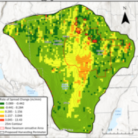 It has been long known that wildfire and harvesting can have a relationship. However, this relationship is not straightforward and well understood. In this paper, we hope to quantify the impact of proposed harvesting on the wildfire severity and probability on Rose Swanson Mountain. Rose Swanson Mountain is a small mountain in South Central BC near the town of Armstrong used by the locals for its bountiful outdoor recreation. In early 2020 British Columbia Timber Sales added part of the Rose Swanson Mountain Sensitive Area to its list of soon-to-be harvested areas. This paper illustrates the research done in BurnP3 and ArcPro to simulate and measure fire in a pre and post logged Rose Swanson.
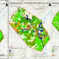 In recent years, the application of remote sensing technology in vegetation change monitoring has played an important role. The purpose of this project is to explore changes in vegetation in the Tumbler Ridge region of British Columbia between the 1940s and 2020 and to discuss the relationship to fire urbanization and deforestation. A series of aerial photographs (taken in the 1940s), Landsat 5 remote sensing images (1985), and forest vegetation composite polygons (2020) were classified and analyzed by Object-Based Image Analysis (OBIA) and Support Vector Machines (SVM) for evaluation Vegetation Composition and Matrix Analysis of Vegetation Change in the Tumbler Ridge Region Using Vegetation Transition Matrix.
 Around the world, the frequency and intensity of wildfire events are rapidly increasing. Such a trend increasingly exposes some communities to the risk of the secondary hazards of wildfire, such as post-wildfire geomorphic events like a landslide and debris flow. To better manage the risk imposed by the secondary hazards of wildfire, a better understanding of the relationship between wildfire activities and the geomorphic events related therewith is necessary. In this paper, the temporal relationship between past wildfire events and the frequency of two different types of geomorphic events (landslides and debris flow) was studied statistically through the conduction of a time series analysis.
 Wildfires remove vegetation and alter soil conditions resulting in increased susceptibility of ground surfaces to erosion, especially over periods of heavy precipitation. Geomorphic changes that are influenced by wildfire occurrence can evolve into hazardous natural events like landslides and flows that pose the risk of human fatality and costly infrastructural damage. We compare light detection and ranging (LiDAR) data time series to identify and compare landscape geomorphic change in burned and unburned areas in the William’s Lake area of the Cariboo Region of British Columbia following the 2017 wildfires.
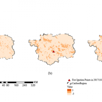 Wildfires can disrupt forest ecosystem, leading to a deterioration of the air quality, and loss of resources, property animals and people. Understanding the driving factors and the spatial distribution of wildfire benefits local forest fire management planning and resource allocation for fire suppression. To analyze how the land surface temperature (LST) anomaly is related to fire frequency, a fire dataset including more than 400 fires occurred in Cariboo region and a daily LST anomaly dataset based on historical MODIS observations were gathered and processed.
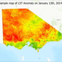 Victoria, Australia has suffered from forest fire for a long period, and forest cover account for almost 25% of land cover. Therefore, it is significant to control fire events especially predict the fire burning effectively. Land surface temperature (LST) anomaly, as an important index, may build a relationship with fire occurrences to help fire management.
 Understanding how resilient forests are after wildfire events is important to forest management practices. The objective of this study was to use Landsat-8 data to understand how the burn severity of the Little Bobtail Lake wildfire has impacted forest regrowth several years later. This was done by deriving different vegetation indices to see how the changes in vegetation health were impacted by burn severity. Additionally, landscape pattern metrics were used to understand the changes in the spatial patterns of the burn severity and vegetation health over time.
 Landscape configuration and composition change are common in rangeland management areas where burning is used to maintain grasslands on slopes. However, little is known about the spatial character of patches within landscapes. The spatial character of landscape patches can be used to link landcover patterns to fire occurrences. We conducted a study to examine the composition and configuration of landscape as a link between landcover types and fires in the Halfway Region – Muskwa Kechika Management Area (M-KMA) in British Columbia.
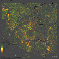 Wildfire drives a tremendous amount of forest and land cover change in the central interior of British Columbia, Canada. Fuel type maps have been acknowledged as critical references to conduct landscape-level fire simulations as well as fire behavior predictions. Nonetheless, the current thematic maps are not updated on an annual basis and cannot be easily produced at a certain scale and speed.
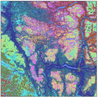 Geospatial analyses focused on quantifying fuel types fragmentation and its autocorrelation with megafire severity inform decision making in contexts such as forest management and human activities regulation. Fuel type fragmentation plays a crucial role in fire severity contribution.
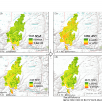 The 2017 Elephant Hill wildfire is considered as one of the most destructive fires in Canada. Wildfires are a major ecosystem disturbance which also causes residential displacement and financial loss. Monitoring vegetation recovery following wildfires becomes crucial to rebuilding the local community and ecological system.
 The Interior Douglas-fir zone of British Columbia’s Cariboo Region evolved alongside wildfire through millennia of repeat exposure. Resulting from these interactions were fire adapted species and landscape configurations that supported low to moderate severity wildfires. Removing the dominant disturbance agent of these dry forest ecosystems through systematic fire suppression has resulted in unforeseen repercussions. Presently, forests of the Interior Douglas-fir zone hold the potential for higher severity wildfire posing an increased threat to human life.