- Predictive Ecosystem Mapping of the Chinchaga Watershed Management Basin, North Eastern British Columbia
Abstract The purpose of this project was to identify and map the location of wetlands in the Chinchaga Watershed Management Basin within the Fort St. John Timber Supply Area. The Chinchaga study area covers 75,000 hectares (ha), and serves as an ecologically significant unit within the Fort St. John Timber Supply Area, representing the gentle,…
Read more: Predictive Ecosystem Mapping of the Chinchaga Watershed Management Basin, North Eastern British Columbia
- Determining Floodplain Characteristics Using Active Remote Sensing
Currently, light detection and ranging (LiDAR) scans have been used to produce 1m & 5m digital elevation models (DEMs) throughout many important drainages across the province and are ideal candidates to effectively inform vegetation classification within floodplain and riparian ecosystems. These ecosystems are highly influenced by fluctuating freshwater regimes and are invaluable in providing, regulating, and supporting various ecosystem functions. This paper explored the extent that various floodplain characteristics, including bench heights and overall floodplain extent, can be modelled using a readily available 1m DEM within the Date Creek Research Forest (DCRF) in northwestern British Columbia (BC), Canada.
- Applying a Faster R-CNN Model Coupled with a Generalized Linear Model to Optical Imagery to Fill Population Data Gaps in Villages along the Southwest Coast of Madagascar
Arid, infertile soil within the southwest of Madagascar creates poor agricultural conditions that have worsened over the years due to climate change. Coastal areas are experiencing rapid population growth due to the allure of marine resources for economic support and food security. However, there exists large uncertainty surrounding how many people rely on these marine resources. As a result, bottom-up management systems have been implemented to mitigate data paucity related to population and marine resource management. This study outlines a methodology for predicting population of coastal villages via detection of artisanal fishing boats, known as pirogues, and houses from the RGB bands in high resolution satellite imagery from Maxar Technologies using a Faster Regions with Convolutional Neural Networks (Faster R-CNN) detection model and a generalized linear model.
- Detection and Monitoring of Wildfire-Induced Earthflows: InSAR Time Series Analysis in the Deadman River Watershed, British Columbia
Abstract This research investigates the efficiency of Interferometric Synthetic Aperture Radar (InSAR) in identifying and tracking changes in earthflow activity and movement post wildfire. The study was conducted in British Columbia’s Deadman River Watershed, which was severely impacted by the Sparks Lake wildfire in 2021, increasing the possibility of landslide reactivation and movement. Using InSARderived…
Read more: Detection and Monitoring of Wildfire-Induced Earthflows: InSAR Time Series Analysis in the Deadman River Watershed, British Columbia
- Generating Synthetic Remote Sensing Data with Deep Learning for Improved Wetland Classification
Abstract Wetlands in the Prairie Pothole region of Canada are critical ecosystems that support biodiversity and provide essential ecosystem services, yet they face increasing threats from agricultural expansion and climate change. Remote sensing offers a powerful tool for monitoring these landscapes over time, enabling large-scale, consistent land cover classification compared to conventional field-based methods. However,…
Read more: Generating Synthetic Remote Sensing Data with Deep Learning for Improved Wetland Classification
- Mapping the Unseen: Identifying Data Gaps and Proposing New Sampling Points in Northern Boreal Mountain Eco-province, BC Using K-Means Clustering and cLHS
Abstract This study investigates the soil variability within the Northern Boreal Mountains Ecoprovince in British Columbia, with a particular focus on wetland soils and soil organic carbon mapping. Utilizing the BCSOIL2020 dataset and an array of environmental covariates, we employed Principal Component Analysis (PCA), k-means clustering, and conditioned Latin Hypercube Sampling (cLHS) to develop a…
Read more: Mapping the Unseen: Identifying Data Gaps and Proposing New Sampling Points in Northern Boreal Mountain Eco-province, BC Using K-Means Clustering and cLHS
- Wetland Mapping: Application of Supervised Classification Using Random Forest in Wetland Prediction
Abstract In response to the necessity for enhanced wetland inventories, this study aimed to assess effectiveness of employing high spatial resolution SPOT imagery (1.5m resolution by Planet Lab) for classifying and detecting wetlands in Atlin, British Columbia, Canada. Utilizing the Random Forest Classifier, featured for its capability in handling high-dimensional spatial data, the research aims…
Read more: Wetland Mapping: Application of Supervised Classification Using Random Forest in Wetland Prediction
- Integrating Hydrological Modeling for Sustainable Forest Management: Rose Swanson Mountain, British Columbia
Abstract The aim of this research was to identify hydrologically sensitive areas (HSAs) on Rose Swanson Mountain, British Columbia. The region of interest is operating as a timber harvesting area for British Columbia Timber Sales (BCTS) without a comprehensive hydrological map. The absence of this hydrology map puts the topography at risk of forest fires,…
Read more: Integrating Hydrological Modeling for Sustainable Forest Management: Rose Swanson Mountain, British Columbia
- Urban Resilience: The Optimization of Sustainable Urban Stormwater Management
Growing urbanization and increased rainfall from climate change are compounding to create high flood risks for urban areas. As the University of British Columbia looks to create a sustainable campus, there are emerging questions of how to improve its stormwater resilience and reduce future flooding. This project uses a GIS rainfall-runoff analysis to assess the comparative performance of potential green infrastructures on campus. By optimizing the design and implementation of green infrastructures, campus planning can successfully enhance UBC’s stormwater resilience, mitigating the combined effects of urbanization and climate change.
- Managing Shifting Precipitation Regimes: Sustainable Stormwater Management at University of British Columbia
In response to growing concerns about climate change, recent studies have investigated the climate change impact on shifting precipitation and storm events. This study expands on this body of work through various analyses using the data from the Environment and Climate Change Canada (ECCC) and UBC Abacus Data Network to understand the effects of shifting precipitation regime on green infrastructure management at the UBC Point Grey campus. Results showed that the existing green infrastructure at UBC is not designed to handle large volumes of precipitation, leading to flooding and erosion risks. This highlights the need for sustainable stormwater management practices that consider each location’s unique characteristics. Several recommendations were made, such as balancing permeable and impermeable surfaces, installing and upgrading green roofs and other green infrastructure, and recording and updating related climate data and performance.
- Are Past Wildfire Activities Correlated with the Frequency of Different Types of Post-Wildfire Geomorphic Events such as Landslides and Debris Flows
Around the world, the frequency and intensity of wildfire events are rapidly increasing. Such a trend increasingly exposes some communities to the risk of the secondary hazards of wildfire, such as post-wildfire geomorphic events like a landslide and debris flow. To better manage the risk imposed by the secondary hazards of wildfire, a better understanding of the relationship between wildfire activities and the geomorphic events related therewith is necessary. In this paper, the temporal relationship between past wildfire events and the frequency of two different types of geomorphic events (landslides and debris flow) was studied statistically through the conduction of a time series analysis.
- Using Repeat-Pass Light Detection and Ranging (LiDAR) Data to Compare Wildfire Induced Geomorphic Change Across Different Burn Severities in the Cariboo Region, British Columbia
Wildfires remove vegetation and alter soil conditions resulting in increased susceptibility of ground surfaces to erosion, especially over periods of heavy precipitation. Geomorphic changes that are influenced by wildfire occurrence can evolve into hazardous natural events like landslides and flows that pose the risk of human fatality and costly infrastructural damage. We compare light detection and ranging (LiDAR) data time series to identify and compare landscape geomorphic change in burned and unburned areas in the William’s Lake area of the Cariboo Region of British Columbia following the 2017 wildfires.
- Using Light Detection and Ranging (LiDAR) and Google Earth imagery to identify whether ponds are connected to stable ground water inputs
The Rangeland Department in the Kamloops District from the Government of British Columbia has recently raised concerns regarding the observation on the reduction of the number and the surface area of the grassland ponds in the Lac du Bois Grasslands Protected Area. This study aims to distinguish between the ponds with stable groundwater inputs (i.e. connected ponds) and the ponds with unstable groundwater inputs (i.e. perched ponds) to assist the government in determining reliable water sources.
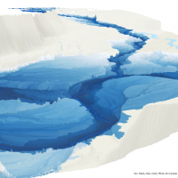 Currently, light detection and ranging (LiDAR) scans have been used to produce 1m & 5m digital elevation models (DEMs) throughout many important drainages across the province and are ideal candidates to effectively inform vegetation classification within floodplain and riparian ecosystems. These ecosystems are highly influenced by fluctuating freshwater regimes and are invaluable in providing, regulating, and supporting various ecosystem functions. This paper explored the extent that various floodplain characteristics, including bench heights and overall floodplain extent, can be modelled using a readily available 1m DEM within the Date Creek Research Forest (DCRF) in northwestern British Columbia (BC), Canada.
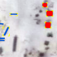 Arid, infertile soil within the southwest of Madagascar creates poor agricultural conditions that have worsened over the years due to climate change. Coastal areas are experiencing rapid population growth due to the allure of marine resources for economic support and food security. However, there exists large uncertainty surrounding how many people rely on these marine resources. As a result, bottom-up management systems have been implemented to mitigate data paucity related to population and marine resource management. This study outlines a methodology for predicting population of coastal villages via detection of artisanal fishing boats, known as pirogues, and houses from the RGB bands in high resolution satellite imagery from Maxar Technologies using a Faster Regions with Convolutional Neural Networks (Faster R-CNN) detection model and a generalized linear model.
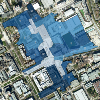 Growing urbanization and increased rainfall from climate change are compounding to create high flood risks for urban areas. As the University of British Columbia looks to create a sustainable campus, there are emerging questions of how to improve its stormwater resilience and reduce future flooding. This project uses a GIS rainfall-runoff analysis to assess the comparative performance of potential green infrastructures on campus. By optimizing the design and implementation of green infrastructures, campus planning can successfully enhance UBC’s stormwater resilience, mitigating the combined effects of urbanization and climate change.
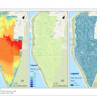 In response to growing concerns about climate change, recent studies have investigated the climate change impact on shifting precipitation and storm events. This study expands on this body of work through various analyses using the data from the Environment and Climate Change Canada (ECCC) and UBC Abacus Data Network to understand the effects of shifting precipitation regime on green infrastructure management at the UBC Point Grey campus. Results showed that the existing green infrastructure at UBC is not designed to handle large volumes of precipitation, leading to flooding and erosion risks. This highlights the need for sustainable stormwater management practices that consider each location’s unique characteristics. Several recommendations were made, such as balancing permeable and impermeable surfaces, installing and upgrading green roofs and other green infrastructure, and recording and updating related climate data and performance.
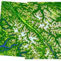 Around the world, the frequency and intensity of wildfire events are rapidly increasing. Such a trend increasingly exposes some communities to the risk of the secondary hazards of wildfire, such as post-wildfire geomorphic events like a landslide and debris flow. To better manage the risk imposed by the secondary hazards of wildfire, a better understanding of the relationship between wildfire activities and the geomorphic events related therewith is necessary. In this paper, the temporal relationship between past wildfire events and the frequency of two different types of geomorphic events (landslides and debris flow) was studied statistically through the conduction of a time series analysis.
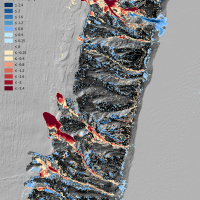 Wildfires remove vegetation and alter soil conditions resulting in increased susceptibility of ground surfaces to erosion, especially over periods of heavy precipitation. Geomorphic changes that are influenced by wildfire occurrence can evolve into hazardous natural events like landslides and flows that pose the risk of human fatality and costly infrastructural damage. We compare light detection and ranging (LiDAR) data time series to identify and compare landscape geomorphic change in burned and unburned areas in the William’s Lake area of the Cariboo Region of British Columbia following the 2017 wildfires.
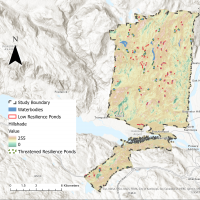 The Rangeland Department in the Kamloops District from the Government of British Columbia has recently raised concerns regarding the observation on the reduction of the number and the surface area of the grassland ponds in the Lac du Bois Grasslands Protected Area. This study aims to distinguish between the ponds with stable groundwater inputs (i.e. connected ponds) and the ponds with unstable groundwater inputs (i.e. perched ponds) to assist the government in determining reliable water sources.