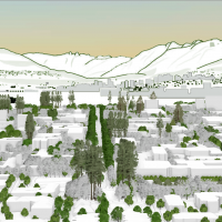
- Examining the University of British Columbia Vancouver campus views using LIDAR data
This study examines the application possibilities of LIDAR data in building a digital model of the campus in three dimensions to: a) assess whether strategic observations point still exist on campus. b) mapping the built landscape across campus. c) determine planning principles for areas of interest where the new building height is considered. The study presents various methods, such as viewshed analysis and raster calculations.
- Determining Floodplain Characteristics Using Active Remote Sensing
Currently, light detection and ranging (LiDAR) scans have been used to produce 1m & 5m digital elevation models (DEMs) throughout many important drainages across the province and are ideal candidates to effectively inform vegetation classification within floodplain and riparian ecosystems. These ecosystems are highly influenced by fluctuating freshwater regimes and are invaluable in providing, regulating, and supporting various ecosystem functions. This paper explored the extent that various floodplain characteristics, including bench heights and overall floodplain extent, can be modelled using a readily available 1m DEM within the Date Creek Research Forest (DCRF) in northwestern British Columbia (BC), Canada.
- Paths and Barriers Identification: Algorithm based on LiDAR data
The wayfinding system is important for the people on campus. However, the existed wayfinding system of UBC does not consider some walkable paths which are not shown on the street map. Also, the wayfinding system ignores the barriers like stairs, which could be obstacles for wheelchair users, on the paths. LiDAR is developed rapidly in recent years. It can collect the elevation information of the objectives on the ground. University of British Columbia (UBC) collects and publishes the LiDAR dataset of campus every year. This project uses the elevation and the point intensity information from the LiDAR point dataset to identify the walkable paths and the barriers on the paths.
- How do shading and cooling of urban forests across the University of British Columbia Vancouver Campus affect building temperatures?
Understanding temporal and spatial variations in environmental conditions is important for determining how urban forests affect ecological communities at the local scale. This study aims to use LiDAR data to investigate how shading and cooling affect urban forests at the UBC Vancouver campus within an ecosystem services framework.
- Predicting Frost-Prone and Cold Air Accumulation Sites from DEMs
Increased deforestation in British Columbia from logging practices and wildfires has led to interests from the BC Ministry of Forests, Lands, Natural Resource Operations, and Rural Development to improve reforestation efforts province-wide. Modelling cold air and frost in BC has limited research prior to this project, and unexpected frost events in Spring and Autumn can have fatal effects to young, newly-planted trees in areas where frost develops on the landscape. The frost project is part of the greater Predictive Ecosystem Mapping project for BC on behalf of the ministry, and will contribute to improved land management practices.
- Exploring the Feasibility of Individual Tree Segmentation Algorithms on Terrestrial LiDAR Data
Abstract Terrestrial Laser Scanning (TLS) offers complementary and non-destructive methods for capturing three-dimensional information on forest structure. ITS is an essential process for modern forestry and ecological studies as it enables the precise isolation and characterization of individual trees from surrounding forest, facilitating critical analyses such as biomass estimation and advanced forest structure assessment. This…
Read more: Exploring the Feasibility of Individual Tree Segmentation Algorithms on Terrestrial LiDAR Data
- Comparative Analysis of Forest Canopy Height Estimation using Random Forest and Support Vector Machine Models with Synthetic Aperture Radar and Optical Imagery
Abstract In this study, the accuracy of forest canopy height estimation was assessed using Synthetic Aperture Radar (SAR), including backscatter and Polarimetric SAR (PolSAR), as well as optical indices derived from optical imagery, and Random Forest (RF) and Support Vector Machine (SVM) models were applied by using canopy heights derived from Light Detection and Ranging…
Read more: Comparative Analysis of Forest Canopy Height Estimation using Random Forest and Support Vector Machine Models with Synthetic Aperture Radar and Optical Imagery
- Comparing PolSAR, SAR and Optical Imagery Integration for Forest Canopy Height Estimation in Interior British Columbia, Canada
Abstract Forest canopy height is an important indicator for estimating forest carbon stock and biomass, which have implications for multiple environmental issues. In remote sensing, canopy height is most commonly measured using light detection and ranging (LiDAR), which comes with satisfactory accuracy but also high costs. This study looked at the potential of using synthetic…
Read more: Comparing PolSAR, SAR and Optical Imagery Integration for Forest Canopy Height Estimation in Interior British Columbia, Canada
- Detection and Monitoring of Wildfire-Induced Earthflows: InSAR Time Series Analysis in the Deadman River Watershed, British Columbia
Abstract This research investigates the efficiency of Interferometric Synthetic Aperture Radar (InSAR) in identifying and tracking changes in earthflow activity and movement post wildfire. The study was conducted in British Columbia’s Deadman River Watershed, which was severely impacted by the Sparks Lake wildfire in 2021, increasing the possibility of landslide reactivation and movement. Using InSARderived…
Read more: Detection and Monitoring of Wildfire-Induced Earthflows: InSAR Time Series Analysis in the Deadman River Watershed, British Columbia
- Detecting Change of Aboveground Biomass (AGB) in Kwahu South, Ghana
Abstract Forest plays a vital role in regulating the global carbon cycle, yet their aboveground biomass (AGB) remains difficult to estimate over large areas due to limitations of field-based measurements. This study addresses the challenge by evaluating satellite-based approaches to estimate AGB in Kwahu South, Ghana. The objective was to determine which optical satellite imagery,…
Read more: Detecting Change of Aboveground Biomass (AGB) in Kwahu South, Ghana
- Comparison of Methods of Multi-Source Remote Sensing Estimations of Aboveground Biomass of Tropical Rainforests in Kwahu South, Ghana
Abstract Aboveground biomass (AGB) is an important metric in forest carbon analysis, allowing for continuous monitoring of changes in biomass over time. Field measurements to provide accurate assessments of these metrics are cost and time-prohibitive, although remote sensing can gather this information quickly and more affordably, and with machine learning models they can achieve robust…
Read more: Comparison of Methods of Multi-Source Remote Sensing Estimations of Aboveground Biomass of Tropical Rainforests in Kwahu South, Ghana
- Visualize Six Years of Architectural Changes at the University of British Columbia Vancouver Campus: Impacts on Tree Growth, Green Connectivity, and Coyote Footprints
Abstract Urban development, such as campus expansion, alters land cover and disrupts ecological processes, but the full extent of these impacts is often underexamined at fine spatial and temporal scales. This study investigates how building expansion on the University of British Columbia (UBC) Vancouver campus from 2015 to 2021 has influenced tree dynamics and coyote…
Read more: Visualize Six Years of Architectural Changes at the University of British Columbia Vancouver Campus: Impacts on Tree Growth, Green Connectivity, and Coyote Footprints
- Evaluating Riparian Function Using LiDAR-Derived Vegetation Intactness and Cattle Accessibility in the Cariboo Region, British Columbia
Abstract Riparian zones provide vital ecological services, such as maintaining water quality, supporting biodiversity, and stabilizing stream banks; however, these areas in British Columbia’s Cariboo Natural Resource Region are increasingly pressured by forestry practices, cattle grazing, and private land management. Traditional cumulative effects assessments rely predominantly on indirect indicators of disturbance potential, which may inaccurately…
Read more: Evaluating Riparian Function Using LiDAR-Derived Vegetation Intactness and Cattle Accessibility in the Cariboo Region, British Columbia
- Integrating LiDAR (Light Detection and Ranging) and Camera Traps to Assess the Influence of Three-Dimensional Forest Structure on Mammal Habitat Use in Coastal Western Hemlock Forests
Abstract Global forest degradation and habitat loss caused have induced the need for advanced methods to assess forest quality and how would these change impacts on animals. Although extensive research has focused on responses of birds to habitat change, the influence of forest structure on mammals has remained underexplored. In southwestern British Columbia, Malcolm Knapp…
Read more: Integrating LiDAR (Light Detection and Ranging) and Camera Traps to Assess the Influence of Three-Dimensional Forest Structure on Mammal Habitat Use in Coastal Western Hemlock Forests
- Mapping Park and Greenspace Value Across the University of British Columbia (UBC) Vancouver Campus
Abstract Greenspaces on university campuses enhance well-being, yet their value varies due to accessibility and usability factors. This study mapped greenspace value across the University of British Columbia (UBC) Vancouver campus, assessing how lighting, accessibility infrastructure, topography and physical barriers influenced inclusivity and usability. Using a geospatial framework, data were collected from UBC infrastructure databases,…
Read more: Mapping Park and Greenspace Value Across the University of British Columbia (UBC) Vancouver Campus
- Supervised Mangrove Classification in Madagascar Comparing Optical Imagery to Combined Optical and Synthetic Aperture Radar Imagery Using Random Forest on Sentinel-1 and Sentinel 2
Abstract Mangrove ecosystems are critical coastal habitats that provide essential services such as shoreline protection, carbon sequestration, and biodiversity support. Monitoring these ecosystems over large and often remote areas can be challenging, making remote sensing a valuable tool for effective observation and management. However, accurate classification of mangroves remains difficult due to spectral and structural…
Read more: Supervised Mangrove Classification in Madagascar Comparing Optical Imagery to Combined Optical and Synthetic Aperture Radar Imagery Using Random Forest on Sentinel-1 and Sentinel 2
- Assessing the Impact of the University of British Columbia Campus Vision 2050 on Eastern Grey Squirrel Habitat Suitability in Acadia Park
Abstract Urban development is a leading driver of habitat fragmentation, with significant implications for wildlife in growing cities. This research investigates how projected urban expansion under the University of British Columbia’s Campus Vision 2050 may impact Eastern Grey Squirrel habitat suitability in Acadia Park, a residential neighborhood on the University of British Columbia Vancouver campus.…
Read more: Assessing the Impact of the University of British Columbia Campus Vision 2050 on Eastern Grey Squirrel Habitat Suitability in Acadia Park
- Evaluating LiDAR technology to Augment Fuel Typing Classification by Enhancing accuracy of Vegetation Resource Indices in The Resort Municipality of Whistler
Abstract This study evaluates the integration of airborne LiDAR (Light Detection and Ranging) data with British Columbia’s Vegetation Resource Inventory (VRI) to identify opportunities for enhancement. LiDAR-derived forest structure metrics were compared against VRI estimates in the Resort Municipality of Whistler, revealing discrepancies and variable correlation strengths. Tree height showed a moderately strong correlation (r…
Read more: Evaluating LiDAR technology to Augment Fuel Typing Classification by Enhancing accuracy of Vegetation Resource Indices in The Resort Municipality of Whistler
- Historically Changed 3D University of British Columbia (UBC) Buildings and Landscapes
Abstract This study addresses the lack of comprehensive 3D documentation of the University of British Columbia (UBC) Vancouver campus’s architectural and ecological evolution from 2015 to 2024. By integrating 2D polygon shapefiles, Light Detection and Ranging (LiDAR) data, Digital Elevation Models, and open-source geographical data, an interactive time-slider enabled 3D model was developed to capture…
Read more: Historically Changed 3D University of British Columbia (UBC) Buildings and Landscapes
- The Impact of Tree Shade on Building Cooling Energy Demand During Summer
Abstract The upsurge of climate change has exacerbated the urban heat island (UHI) effect, leading to severe consequences for human health, urban livability, and energy demand. Rising temperatures significantly increase the demand for cooling energy, as the cooling load of buildings is heavily influenced by the amount of solar radiation reaching their surfaces. One of…
Read more: The Impact of Tree Shade on Building Cooling Energy Demand During Summer
- Combining Multi-Season Multispectral Imagery and Airborne Laser Scanning Data to Improve Predicted Quercus garryana Distribution
Abstract Garry oak ecosystems are one of North America’s most distinctive and ecologically significant ecosystems. Currently, only 1–5% of their historical extent remains in near-natural condition. Effective conservation requires accurate information on Garry oak distribution and forest composition. Remote sensing and machine learning offer advantages over traditional methods in terms of resources and scalability. Spectral…
Read more: Combining Multi-Season Multispectral Imagery and Airborne Laser Scanning Data to Improve Predicted Quercus garryana Distribution
- Deriving airborne LiDAR metrics to estimate ladder fuel density in Whistler, British Columbia
Abstract With increasing wildfire frequency and severity, understanding ladder fuels—vegetation structures facilitating fire propagation from forest floors to canopies—is crucial for effective wildfire management. Active remote sensors, such as light detection and ranging (LiDAR), are able to penetrate the forest canopy and allow for the characterization of understory vegetation structures. This study investigates the use…
Read more: Deriving airborne LiDAR metrics to estimate ladder fuel density in Whistler, British Columbia
- Comparing the Accuracy of Polarimetric Synthetic Aperture Radar (PolSAR) Canopy Height Models for Forests in the Pacific Maritime and Montane Cordillera Ecozones
Abstract Land management practices increasingly depend on detailed forest structure information, including canopy height, necessitating the adoption of advanced remote sensing methodologies. This research contributes to meeting this demand by leveraging polarimetric synthetic aperture radar (PolSAR) data, integrated with multispectral imagery, to model forest canopy height in the Pacific Maritime and the Montane Cordillera ecozones…
Read more: Comparing the Accuracy of Polarimetric Synthetic Aperture Radar (PolSAR) Canopy Height Models for Forests in the Pacific Maritime and Montane Cordillera Ecozones
- Impact of Forest Age and Forest Type on the Accuracy of Canopy Height Estimation by Synthetic Aperture Radar and Optical Imagery
Abstract Forest canopy height measurement is critical for forest resources management, several remote sensing techniques have been applied to estimate the canopy height, including Light Detection and Ranging (LiDAR). However, the limited publicly available LiDAR data in British Columbia, limitation by clouds, and the cost create some challenges. To overcome this issue, this study employed…
Read more: Impact of Forest Age and Forest Type on the Accuracy of Canopy Height Estimation by Synthetic Aperture Radar and Optical Imagery
- Using LiDAR to characterize urban forest structure and composition and locate hotspots based on derived individual tree attributes
Abstract This study provides urban forest tree inventories for the University Endowment Lands, Pacific Spirit Regional Park, Musqueam First Nation, and Southlands of British Columbia for 2015 and 2021. It describes urban forest structure and composition based on LiDAR-derived urban forest attributes including tree count, maximum height (zmax), crown area, and species type (coniferous/broadleaf). Hotspot…
Read more: Using LiDAR to characterize urban forest structure and composition and locate hotspots based on derived individual tree attributes
- Using LiDAR-based Inventories to Evaluate the Impact of Silvicultural Practices on Forest Biomass
Abstract Forests are crucial in absorbing and storing carbon in land-based ecosystems, and their proper management is essential for mitigating climate change. This study assesses the influence of silvicultural systems on the amount of forest carbon in the Boundary Timber Supply Area (TSA) located in BC. The evaluation is based on enhanced forest inventories conducted…
Read more: Using LiDAR-based Inventories to Evaluate the Impact of Silvicultural Practices on Forest Biomass
- Exploring Potential Benefits of Visualizing Canopy Cover Change in 3D Gaming Engine Environment
Abstract This research explores the innovative use of a 3D gaming engine, Minetest, for visualizing changes in canopy cover change at the University of British Columbia (UBC) campus, addressing the pressing challenge of urban expansion on green spaces. We compared and visualized canopy height change for UBC campus in both 2D traditional environment and 3D…
Read more: Exploring Potential Benefits of Visualizing Canopy Cover Change in 3D Gaming Engine Environment
- Deriving LiDAR Metrics for Forest Structure Mapping in Wildfire Risk Assessment
Abstract The escalating incidents of wildfire pose a critical challenge in Canada, necessitating an understanding of forest structures for the effective implementation of fuel treatment strategies to mitigate wildfire risks. While previous research has explored forest structures and wildfire risk, a gap remains in translating these studies into operational solutions for foresters and land managers.…
Read more: Deriving LiDAR Metrics for Forest Structure Mapping in Wildfire Risk Assessment
- Using LiDAR Data to Analyze the Habitat Suitability for Birds and Create the Minetest Digital Twin Model of UBC Botanical Garden
This project aims to guide the University of British Columbia Botanical Garden to create Bird-friendly green spaces by using LiDAR data to analyze and map UBCBG’s bird habitat suitability and create a 3D digital twin model of UBCBG in the open source game engine Minetest to increase 3D visualization and aid in landscape planning. By extracting the Canopy Height Model (CHM) and performing individual tree segmentation, the derived metrics were used to identify trees with the highest bird habitat suitability index. This study is highly relevant for landscape adaptation and planning in conjunction with other management considerations to support bird-friendly green spaces. The digital twin model can be used for educational and promotional purposes and landscape planning and aesthetic design with the consideration of bird conservation.
- Old-Growth Attributes Prediction in the Coastal Western Hemlock Ecosystem, British Columbia using LiDAR
Old-growth forests have complex structures that provide critical habitat for endangered species and enhance biodiversity and ecosystem services. Old-growth forests have become rare due to harvesting. In order to support the recovery process of old-growth forests in British Columbia, it is valuable to identify old-growth characteristics in recovering forests for conservation purposes. This study attempted to predict the distribution of old-growth attributes in the Coastal Western Hemlock (CWH) zone in British Columbia using area-based LiDAR metrics. LiDAR point clouds of 61 forestry inventory plots were extracted to generate LiDAR metrics to create multilinear regression models for four old-growth attributes: standard deviation of diameter at breast height (DBH), maximum tree DBH, average live crown percentage, and the sum of understory plants percentage. The results showed the ability of LiDAR to predict varied by old-growth attributes and were highest for the standard deviation of DBH, followed by Maximum Tree DBH, the Sum of understory plants percentage and lowest for average live crown percentage. An old-growth index was derived from four old-growth attributes for mapping the potential locations of old-growth. However, the validation results of 19.08% from vegetation resource inventory (VRI) illustrate that the old-growth index does not successfully identify old growth. Despite the challenges, the prediction results can still be used to identify old-growth attributes and enhance knowledge of old-growth landscapes. Also, this study has potential applications in old-growth forest restoration and supports government’s old-growth management plans.
- Exploring the Potential of 3D Game Engines for Precise and Detailed Geo-Visualization in Forestry Education
In response to the growing concern in geographic information science, which pertains to utilizing contemporary internet technology to communicate past information or knowledge for establishing foundations in geography. Recent studies have investigated geomatics solutions for historical city, and enhancing GIS skills through collaborative approach. This study built upon prior research by exploring how the implementation of current technology can promote a cooperative learning environment, particularly within the realm of forestry education. Minetest, the 3D voxel game engine has high capability of modification, for visualizing natural environments and urban structures. The goal of this study was to investigate the potential of using the game engine for forestry education purposes. We developed precise and detailed models of building structures and their surrounding environment. We also explored the visualization beyond 3D geospatial data, by generating analytical results of solar radiation on building roofs using GIS software. The visualization process was facilitated by the use of 3D light detection and ranging (LiDAR) data, provided by the UBC Campus + Community Planning department. The proposed approach proved to be effective in producing compatible geospatial data for visualization in the game engine. We also conducted exploratory statistical analysis to examine the relationship between building energy usage and solar radiation. The exploratory regression result indicates its insignificant impact on building energy usage. Finally, the research findings provide a foundation for future studies that can continue to explore the potential of using 3D game engines.
- Mapping the Historical Trails of Rose Swanson Mountain
In response to growing concerns about the limited accessibility and preservation of historical trails at Rose Swanson Mountain, this study uses aerial photos and GIS to digitize these trails. Our goal is to create a comprehensive and accurate digital map of the trails while examining the impact of logging and forest fires on their length and location. The results indicate that the total length of the trails in Rose Swanson Mountain has significantly decreased due to logging activities and regulations set by the BC Ministry of Forestry. Additionally, we found that most of the existing trails are located within a sensitive area. Our study also highlighted the limitations of using aerial photography for digitizing historical trails, including the difficulty of identifying trails from air photos and the accuracy of the georeferencing process. The digital map of the historical trails can significantly contribute to the preservation of local indigenous culture and promote sustainable forest management practices that consider both economic benefits and ecological benefits. Our findings can guide policymakers in assessing the impact of logging on forests near Canadian indigenous traditional community areas and implementing regulations to mitigate these effects. Future studies can explore the benefits of preserving the forest and historical trails, such as the forest’s carbon storage potential and the economic contribution of the trail system to the local economy.
- Predicting Forage Availability from Open Source LiDAR Data
Livestock forage availability is an important factor when allocating land for grazing animals. Due to the variation in British Columbia’s topography and plant communities, rangeland management faces unique challenges with natural resource operations and rural development. The goal of this study was to create a predictive model of forage availability using light detection and ranging (LiDAR) data from the Open LiDAR Data Portal and biometric ground truthing data from the Vegetation Resource Index.
- Understanding Microclimate in University of British Columbia’s Botanical Garden
Climate change is a key factor in how extreme weather events affect how ecosystems and species react to these changes in temperatures. University of British Columbia’s (UBC) Botanical Garden is interested in improving microclimate information within the garden to understand how areas with shade create respite zones for species. Due to the recent extreme weather temperatures in Vancouver, the garden is interested in how to continue to adapt and mitigate to these extremes. Microclimates are important as they are cooler temperatures beneath the canopy. Looking at how canopy cover influences land surface temperature can give insight on microclimates. Using LiDAR metrics to calculate canopy cover and Landsat to calculate land surface temperature, a model was built to understand the significance of canopy cover and land surface temperature, with the addition of other LiDAR metrics.
- Comparing the Level of Above-ground Carbon Sequestration and Respective Ecosystem Services between Native and Cultivated Trees in the University of British Columbia Botanical Garden
Urban trees play an essential role in alleviating the local effects of global warming by sequestering atmospheric carbon dioxide, regulating temperature and reducing air pollution in urban areas. There have been studies estimating carbon sequestration of urban trees using Light Detection and Ranging (LiDAR). Yet, neither of the studies made comparison between species nor extended the discussion towards ecosystem services. Therefore, this study compared the attributes between native and cultivated trees in the Asian Garden of the University of British Columbia (UBC) Botanical Garden, estimated their level of above-ground carbon sequestration, and thus examined respective implications in terms of ecosystem services.
- Snag Detection In The Interior Douglas-Fir Zone Of British Columbia Using Area-Based Lidar Metrics
Snags (dead standing trees) form an important structural aspect of a forest and perform many essential ecological functions such as habitat provision. As such, substantial research has investigated various methods of snag detection using lidar. One approach is to compute areal lidar metrics such as slope, elevation, canopy height, etc. to detect snags. However, it remains unclear which lidar metrics are best suited for snag detection. This study attempted to predict snag presence/absence and density in the Interior Douglas-Fir (IDF) zone in British Columbia using area based lidar metrics.
- Evaluation of snag density and snag metrics in Old Growth Deferral Priority Areas in the Cariboo region using airborne LiDAR data
Standing dead trees (snags) are crucial habitats for fauna in mature and diverse forests along the Interior Douglas-fir Zone of British Columbia. The objective of this study is to evaluate whether snag density and snag metrics differ between three categories of at-risk and irreplaceable Old Growth Priority Deferral Areas (ancient, big-treed and remnant) and their neighbouring areas with no deferral status. Using airborne LiDAR data, we detect snags using 1) area-based forest metrics paired with random forest modelling, and 2) an individual snag detection algorithm.
- Examining the relationship between Landsat-derived spectral reflectance and multispectral Light Detection and Ranging (LiDAR)-derived intensity in Petawawa Research Forest, Ontario, Canada
Traditionally, Light Detection and Ranging (LiDAR) was used for forest structure analysis rather than capturing spectral information. A variety of studies were conducted to investigate the spectral characteristics of multispectral LiDAR but relatively few ones have integrated it with Landsat imageries. To compare their recorded reflectance and explore the prediction potential, we evaluated two series of regression modules measuring forest reflected energy with Landsat-derived reflectance and multispectral LiDAR-derived intensity, collected over 85 plots with the same area of 1000 m2 in Petawawa Research Forest, Ontario.
- Pollinators Habitat Capability Analysis of the University of British Columbia (UBC) Vancouver Campus
Pollination is an essential ecosystem service for crop production, where species such as insects and birds help to transfer pollen for plants to reproduce. Many of the pollinators are fully dependent on the plants and trees as their food sources and habitat. From a perspective of an urban planner, we must be able to recognize the values brought by pollinators to our ecosystems. Thus, we are attempting to discover the relationship between species and their habitats as much as possible.
- Monitor Forest height growth using Light Detection and Ranging (LiDAR) canopy height models from 2005 to 2018 at the Petawawa Research Forest
Monitoring the growth of trees is important for sustainable forest management. The traditional method of monitoring forest growth at a broad level is timber cruising by humans, while modern remote sensing technology, especially Lidar, is usually used for monitoring at the single-tree level or stand-level.
- Using Light Detection and Ranging (LiDAR) and Google Earth imagery to identify whether ponds are connected to stable ground water inputs
The Rangeland Department in the Kamloops District from the Government of British Columbia has recently raised concerns regarding the observation on the reduction of the number and the surface area of the grassland ponds in the Lac du Bois Grasslands Protected Area. This study aims to distinguish between the ponds with stable groundwater inputs (i.e. connected ponds) and the ponds with unstable groundwater inputs (i.e. perched ponds) to assist the government in determining reliable water sources.
 This study examines the application possibilities of LIDAR data in building a digital model of the campus in three dimensions to: a) assess whether strategic observations point still exist on campus. b) mapping the built landscape across campus. c) determine planning principles for areas of interest where the new building height is considered. The study presents various methods, such as viewshed analysis and raster calculations.
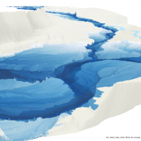 Currently, light detection and ranging (LiDAR) scans have been used to produce 1m & 5m digital elevation models (DEMs) throughout many important drainages across the province and are ideal candidates to effectively inform vegetation classification within floodplain and riparian ecosystems. These ecosystems are highly influenced by fluctuating freshwater regimes and are invaluable in providing, regulating, and supporting various ecosystem functions. This paper explored the extent that various floodplain characteristics, including bench heights and overall floodplain extent, can be modelled using a readily available 1m DEM within the Date Creek Research Forest (DCRF) in northwestern British Columbia (BC), Canada.
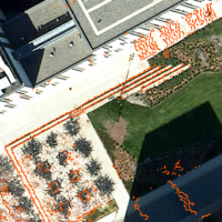 The wayfinding system is important for the people on campus. However, the existed wayfinding system of UBC does not consider some walkable paths which are not shown on the street map. Also, the wayfinding system ignores the barriers like stairs, which could be obstacles for wheelchair users, on the paths. LiDAR is developed rapidly in recent years. It can collect the elevation information of the objectives on the ground. University of British Columbia (UBC) collects and publishes the LiDAR dataset of campus every year. This project uses the elevation and the point intensity information from the LiDAR point dataset to identify the walkable paths and the barriers on the paths.
 Understanding temporal and spatial variations in environmental conditions is important for determining how urban forests affect ecological communities at the local scale. This study aims to use LiDAR data to investigate how shading and cooling affect urban forests at the UBC Vancouver campus within an ecosystem services framework.
 Increased deforestation in British Columbia from logging practices and wildfires has led to interests from the BC Ministry of Forests, Lands, Natural Resource Operations, and Rural Development to improve reforestation efforts province-wide. Modelling cold air and frost in BC has limited research prior to this project, and unexpected frost events in Spring and Autumn can have fatal effects to young, newly-planted trees in areas where frost develops on the landscape. The frost project is part of the greater Predictive Ecosystem Mapping project for BC on behalf of the ministry, and will contribute to improved land management practices.
 This project aims to guide the University of British Columbia Botanical Garden to create Bird-friendly green spaces by using LiDAR data to analyze and map UBCBG’s bird habitat suitability and create a 3D digital twin model of UBCBG in the open source game engine Minetest to increase 3D visualization and aid in landscape planning. By extracting the Canopy Height Model (CHM) and performing individual tree segmentation, the derived metrics were used to identify trees with the highest bird habitat suitability index. This study is highly relevant for landscape adaptation and planning in conjunction with other management considerations to support bird-friendly green spaces. The digital twin model can be used for educational and promotional purposes and landscape planning and aesthetic design with the consideration of bird conservation.
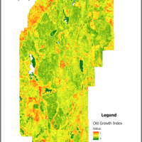 Old-growth forests have complex structures that provide critical habitat for endangered species and enhance biodiversity and ecosystem services. Old-growth forests have become rare due to harvesting. In order to support the recovery process of old-growth forests in British Columbia, it is valuable to identify old-growth characteristics in recovering forests for conservation purposes. This study attempted to predict the distribution of old-growth attributes in the Coastal Western Hemlock (CWH) zone in British Columbia using area-based LiDAR metrics. LiDAR point clouds of 61 forestry inventory plots were extracted to generate LiDAR metrics to create multilinear regression models for four old-growth attributes: standard deviation of diameter at breast height (DBH), maximum tree DBH, average live crown percentage, and the sum of understory plants percentage. The results showed the ability of LiDAR to predict varied by old-growth attributes and were highest for the standard deviation of DBH, followed by Maximum Tree DBH, the Sum of understory plants percentage and lowest for average live crown percentage. An old-growth index was derived from four old-growth attributes for mapping the potential locations of old-growth. However, the validation results of 19.08% from vegetation resource inventory (VRI) illustrate that the old-growth index does not successfully identify old growth. Despite the challenges, the prediction results can still be used to identify old-growth attributes and enhance knowledge of old-growth landscapes. Also, this study has potential applications in old-growth forest restoration and supports government’s old-growth management plans.
 In response to the growing concern in geographic information science, which pertains to utilizing contemporary internet technology to communicate past information or knowledge for establishing foundations in geography. Recent studies have investigated geomatics solutions for historical city, and enhancing GIS skills through collaborative approach. This study built upon prior research by exploring how the implementation of current technology can promote a cooperative learning environment, particularly within the realm of forestry education. Minetest, the 3D voxel game engine has high capability of modification, for visualizing natural environments and urban structures. The goal of this study was to investigate the potential of using the game engine for forestry education purposes. We developed precise and detailed models of building structures and their surrounding environment. We also explored the visualization beyond 3D geospatial data, by generating analytical results of solar radiation on building roofs using GIS software. The visualization process was facilitated by the use of 3D light detection and ranging (LiDAR) data, provided by the UBC Campus + Community Planning department. The proposed approach proved to be effective in producing compatible geospatial data for visualization in the game engine. We also conducted exploratory statistical analysis to examine the relationship between building energy usage and solar radiation. The exploratory regression result indicates its insignificant impact on building energy usage. Finally, the research findings provide a foundation for future studies that can continue to explore the potential of using 3D game engines.
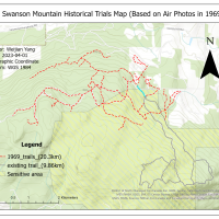 In response to growing concerns about the limited accessibility and preservation of historical trails at Rose Swanson Mountain, this study uses aerial photos and GIS to digitize these trails. Our goal is to create a comprehensive and accurate digital map of the trails while examining the impact of logging and forest fires on their length and location. The results indicate that the total length of the trails in Rose Swanson Mountain has significantly decreased due to logging activities and regulations set by the BC Ministry of Forestry. Additionally, we found that most of the existing trails are located within a sensitive area. Our study also highlighted the limitations of using aerial photography for digitizing historical trails, including the difficulty of identifying trails from air photos and the accuracy of the georeferencing process. The digital map of the historical trails can significantly contribute to the preservation of local indigenous culture and promote sustainable forest management practices that consider both economic benefits and ecological benefits. Our findings can guide policymakers in assessing the impact of logging on forests near Canadian indigenous traditional community areas and implementing regulations to mitigate these effects. Future studies can explore the benefits of preserving the forest and historical trails, such as the forest’s carbon storage potential and the economic contribution of the trail system to the local economy.
 Livestock forage availability is an important factor when allocating land for grazing animals. Due to the variation in British Columbia’s topography and plant communities, rangeland management faces unique challenges with natural resource operations and rural development. The goal of this study was to create a predictive model of forage availability using light detection and ranging (LiDAR) data from the Open LiDAR Data Portal and biometric ground truthing data from the Vegetation Resource Index.
 Climate change is a key factor in how extreme weather events affect how ecosystems and species react to these changes in temperatures. University of British Columbia’s (UBC) Botanical Garden is interested in improving microclimate information within the garden to understand how areas with shade create respite zones for species. Due to the recent extreme weather temperatures in Vancouver, the garden is interested in how to continue to adapt and mitigate to these extremes. Microclimates are important as they are cooler temperatures beneath the canopy. Looking at how canopy cover influences land surface temperature can give insight on microclimates. Using LiDAR metrics to calculate canopy cover and Landsat to calculate land surface temperature, a model was built to understand the significance of canopy cover and land surface temperature, with the addition of other LiDAR metrics.
 Urban trees play an essential role in alleviating the local effects of global warming by sequestering atmospheric carbon dioxide, regulating temperature and reducing air pollution in urban areas. There have been studies estimating carbon sequestration of urban trees using Light Detection and Ranging (LiDAR). Yet, neither of the studies made comparison between species nor extended the discussion towards ecosystem services. Therefore, this study compared the attributes between native and cultivated trees in the Asian Garden of the University of British Columbia (UBC) Botanical Garden, estimated their level of above-ground carbon sequestration, and thus examined respective implications in terms of ecosystem services.
 Snags (dead standing trees) form an important structural aspect of a forest and perform many essential ecological functions such as habitat provision. As such, substantial research has investigated various methods of snag detection using lidar. One approach is to compute areal lidar metrics such as slope, elevation, canopy height, etc. to detect snags. However, it remains unclear which lidar metrics are best suited for snag detection. This study attempted to predict snag presence/absence and density in the Interior Douglas-Fir (IDF) zone in British Columbia using area based lidar metrics.
 Standing dead trees (snags) are crucial habitats for fauna in mature and diverse forests along the Interior Douglas-fir Zone of British Columbia. The objective of this study is to evaluate whether snag density and snag metrics differ between three categories of at-risk and irreplaceable Old Growth Priority Deferral Areas (ancient, big-treed and remnant) and their neighbouring areas with no deferral status. Using airborne LiDAR data, we detect snags using 1) area-based forest metrics paired with random forest modelling, and 2) an individual snag detection algorithm.
 Traditionally, Light Detection and Ranging (LiDAR) was used for forest structure analysis rather than capturing spectral information. A variety of studies were conducted to investigate the spectral characteristics of multispectral LiDAR but relatively few ones have integrated it with Landsat imageries. To compare their recorded reflectance and explore the prediction potential, we evaluated two series of regression modules measuring forest reflected energy with Landsat-derived reflectance and multispectral LiDAR-derived intensity, collected over 85 plots with the same area of 1000 m2 in Petawawa Research Forest, Ontario.
 Pollination is an essential ecosystem service for crop production, where species such as insects and birds help to transfer pollen for plants to reproduce. Many of the pollinators are fully dependent on the plants and trees as their food sources and habitat. From a perspective of an urban planner, we must be able to recognize the values brought by pollinators to our ecosystems. Thus, we are attempting to discover the relationship between species and their habitats as much as possible.
 Monitoring the growth of trees is important for sustainable forest management. The traditional method of monitoring forest growth at a broad level is timber cruising by humans, while modern remote sensing technology, especially Lidar, is usually used for monitoring at the single-tree level or stand-level.
 The Rangeland Department in the Kamloops District from the Government of British Columbia has recently raised concerns regarding the observation on the reduction of the number and the surface area of the grassland ponds in the Lac du Bois Grasslands Protected Area. This study aims to distinguish between the ponds with stable groundwater inputs (i.e. connected ponds) and the ponds with unstable groundwater inputs (i.e. perched ponds) to assist the government in determining reliable water sources.