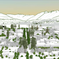
- Examining the University of British Columbia Vancouver campus views using LIDAR data
This study examines the application possibilities of LIDAR data in building a digital model of the campus in three dimensions to: a) assess whether strategic observations point still exist on campus. b) mapping the built landscape across campus. c) determine planning principles for areas of interest where the new building height is considered. The study presents various methods, such as viewshed analysis and raster calculations.
- Paths and Barriers Identification: Algorithm based on LiDAR data
The wayfinding system is important for the people on campus. However, the existed wayfinding system of UBC does not consider some walkable paths which are not shown on the street map. Also, the wayfinding system ignores the barriers like stairs, which could be obstacles for wheelchair users, on the paths. LiDAR is developed rapidly in recent years. It can collect the elevation information of the objectives on the ground. University of British Columbia (UBC) collects and publishes the LiDAR dataset of campus every year. This project uses the elevation and the point intensity information from the LiDAR point dataset to identify the walkable paths and the barriers on the paths.
- How do shading and cooling of urban forests across the University of British Columbia Vancouver Campus affect building temperatures?
Understanding temporal and spatial variations in environmental conditions is important for determining how urban forests affect ecological communities at the local scale. This study aims to use LiDAR data to investigate how shading and cooling affect urban forests at the UBC Vancouver campus within an ecosystem services framework.
- Mapping Incremental Loss of Biodiversity Through Zoning
Abstract As urbanization escalates, reconciling human development with ecological preservation becomes imperative. This study addresses the challenge by assessing the incremental loss of biodiversity within the District of Sechelt, British Columbia, due to land use zoning. Focusing on a region renowned for its diverse ecosystems, the research evaluates current zoning practices, identifies potential threats to…
Read more: Mapping Incremental Loss of Biodiversity Through Zoning
- Density Transfer Potential Mapping in Regional District of Nanaimo and Denman Island
Abstract To address the dual challenges of urban expansion and ecological conservation, this study explores the efficiency of density transfer mechanisms within the Regional District of Nanaimo and Denman Island. Through a detailed analysis using the Normalized Difference Built-Up Index (NDBI) from Sentinel-2 imagery and Sensitive Ecosystem Inventory data, the study identified potential donor and…
Read more: Density Transfer Potential Mapping in Regional District of Nanaimo and Denman Island
- Energy Consumption Comparison Between Electric Vehicles and Internal Combustion Vehicles Traveling Between Horseshoe Bay and Whistler with BEVER Tool
Abstract The transportation sector is a major contributor to global greenhouse gas emissions, prompting a growing shift toward electric vehicles (EVs) as a climate mitigation strategy. EVs are known for their efficiency, but how they perform in hilly or mountainous terrain highway still needs closer study. This study investigates the energy consumption and cost efficiency…
Read more: Energy Consumption Comparison Between Electric Vehicles and Internal Combustion Vehicles Traveling Between Horseshoe Bay and Whistler with BEVER Tool
- Modeling Tree Shade Coverage: Planting Recommendations for Optimizing Shade on the University of British Columbia Vancouver Campus
Abstract Tree shade in urban environments serves to improve human thermal comfort and building energy use during the summer months. Under future climates, tree shade becomes an even more important ecosystem service that promotes climate change resilience. Tree shade was modelled in order to optimize shade coverage on the University of British Columbia (UBC) Vancouver…
Read more: Modeling Tree Shade Coverage: Planting Recommendations for Optimizing Shade on the University of British Columbia Vancouver Campus
- Modeling Climate Resilient Planting Locations of Culturally Significant Plants for Musqueam on the University of British Columbia’s Vancouver Campus
Abstract Urban greenspaces provide essential ecosystem services, enhance biodiversity, and hold cultural significance, particularly for Indigenous communities. However, these areas are increasingly threatened by climate change, urbanization, and invasive species. While greenspace planning and species distribution modeling are established tools for supporting ecological resilience, few studies integrate future climate suitability into site-specific planting guidelines. This…
Read more: Modeling Climate Resilient Planting Locations of Culturally Significant Plants for Musqueam on the University of British Columbia’s Vancouver Campus
- Promoting human-wildlife coexistence through ecological connectivity modelling on the University of British Columbia Vancouver campus
Abstract Urban landscape networks of connected habitat nodes are expanding and play an important role in shaping the biosphere. Within these networks, humans and wildlife coexist, living and moving in close proximity with the potential for conflict. Remotely sensed data provides accurate knowledge of landscape cover. Circuit-based ecological connectivity models can simulate the movement of…
Read more: Promoting human-wildlife coexistence through ecological connectivity modelling on the University of British Columbia Vancouver campus
- Mapping Park and Greenspace Value Across the University of British Columbia (UBC) Vancouver Campus
Abstract Greenspaces on university campuses enhance well-being, yet their value varies due to accessibility and usability factors. This study mapped greenspace value across the University of British Columbia (UBC) Vancouver campus, assessing how lighting, accessibility infrastructure, topography and physical barriers influenced inclusivity and usability. Using a geospatial framework, data were collected from UBC infrastructure databases,…
Read more: Mapping Park and Greenspace Value Across the University of British Columbia (UBC) Vancouver Campus
- Assessing the Impact of the University of British Columbia Campus Vision 2050 on Eastern Grey Squirrel Habitat Suitability in Acadia Park
Abstract Urban development is a leading driver of habitat fragmentation, with significant implications for wildlife in growing cities. This research investigates how projected urban expansion under the University of British Columbia’s Campus Vision 2050 may impact Eastern Grey Squirrel habitat suitability in Acadia Park, a residential neighborhood on the University of British Columbia Vancouver campus.…
Read more: Assessing the Impact of the University of British Columbia Campus Vision 2050 on Eastern Grey Squirrel Habitat Suitability in Acadia Park
- Evaluating LiDAR technology to Augment Fuel Typing Classification by Enhancing accuracy of Vegetation Resource Indices in The Resort Municipality of Whistler
Abstract This study evaluates the integration of airborne LiDAR (Light Detection and Ranging) data with British Columbia’s Vegetation Resource Inventory (VRI) to identify opportunities for enhancement. LiDAR-derived forest structure metrics were compared against VRI estimates in the Resort Municipality of Whistler, revealing discrepancies and variable correlation strengths. Tree height showed a moderately strong correlation (r…
Read more: Evaluating LiDAR technology to Augment Fuel Typing Classification by Enhancing accuracy of Vegetation Resource Indices in The Resort Municipality of Whistler
- Historically Changed 3D University of British Columbia (UBC) Buildings and Landscapes
Abstract This study addresses the lack of comprehensive 3D documentation of the University of British Columbia (UBC) Vancouver campus’s architectural and ecological evolution from 2015 to 2024. By integrating 2D polygon shapefiles, Light Detection and Ranging (LiDAR) data, Digital Elevation Models, and open-source geographical data, an interactive time-slider enabled 3D model was developed to capture…
Read more: Historically Changed 3D University of British Columbia (UBC) Buildings and Landscapes
- Exploring Social Interactions in Vancouver’s Neighbourhood Parks Through Sentiment Analysis of Google Reviews
Abstract Understanding social cohesion in urban green spaces is essential for fostering inclusive and resilient communities. This study analyzes social sentiment in Vancouver parks using a transfer learning natural language processing (NLP) approach to classify and interpret visitor reviews. A self-attention deep learning model was trained to detect social cohesion–related sentiment and categorize it into…
Read more: Exploring Social Interactions in Vancouver’s Neighbourhood Parks Through Sentiment Analysis of Google Reviews
- Mapping Invasive Highbush Blueberry in Richmond Nature Park: A Multi-temporal Normalized Difference Vegetation Index (NDVI) and Spectral Analysis Approach for Peatland Conservation
Abstract This study demonstrates the application of multi-temporal Normalized Difference Vegetation Index (NDVI) analysis and red-band spectral signatures from Sentinel-2 imagery to map the distribution of invasive highbush blueberry (Vaccinium corymbosum) within Richmond Nature Park, British Columbia. Located in the Lulu Island Bog, this critical peat ecosystem faces significant ecological threats from invasive species that…
Read more: Mapping Invasive Highbush Blueberry in Richmond Nature Park: A Multi-temporal Normalized Difference Vegetation Index (NDVI) and Spectral Analysis Approach for Peatland Conservation
- The Impact of Tree Shade on Building Cooling Energy Demand During Summer
Abstract The upsurge of climate change has exacerbated the urban heat island (UHI) effect, leading to severe consequences for human health, urban livability, and energy demand. Rising temperatures significantly increase the demand for cooling energy, as the cooling load of buildings is heavily influenced by the amount of solar radiation reaching their surfaces. One of…
Read more: The Impact of Tree Shade on Building Cooling Energy Demand During Summer
- Other Effective area-based Conservation Measure (OECM) Identification in Átl’ka7tsem / Howe Sound Biosphere Region
Abstract To support Canada’s ambitious conservation commitments of protecting 25% of its terrestrial and marine ecosystems by 2025, and 30% by 2030, new and flexible conservation approaches are necessary. Other Effective Area-Based Conservation Measures (OECMs) represent an opportunity to achieve these targets by recognizing biodiversity conservation occurring indirectly through existing land uses rather than explicitly…
Read more: Other Effective area-based Conservation Measure (OECM) Identification in Átl’ka7tsem / Howe Sound Biosphere Region
- Deriving airborne LiDAR metrics to estimate ladder fuel density in Whistler, British Columbia
Abstract With increasing wildfire frequency and severity, understanding ladder fuels—vegetation structures facilitating fire propagation from forest floors to canopies—is crucial for effective wildfire management. Active remote sensors, such as light detection and ranging (LiDAR), are able to penetrate the forest canopy and allow for the characterization of understory vegetation structures. This study investigates the use…
Read more: Deriving airborne LiDAR metrics to estimate ladder fuel density in Whistler, British Columbia
- Mapping Equity Access to Green Spaces Across The University of British Columbia Vancouver Campus
Abstract Green spaces play an important role in providing ecosystem services such as air purification, temperature regulation, and recreational opportunities; however, their unequal distribution often highlights environmental inequities. This study examines the spatial distribution of green space coverage across the University of British Columbia (UBC) Vancouver campus to identify areas with limited access, termed Equity…
Read more: Mapping Equity Access to Green Spaces Across The University of British Columbia Vancouver Campus
- Exploring Potential Benefits of Visualizing Canopy Cover Change in 3D Gaming Engine Environment
Abstract This research explores the innovative use of a 3D gaming engine, Minetest, for visualizing changes in canopy cover change at the University of British Columbia (UBC) campus, addressing the pressing challenge of urban expansion on green spaces. We compared and visualized canopy height change for UBC campus in both 2D traditional environment and 3D…
Read more: Exploring Potential Benefits of Visualizing Canopy Cover Change in 3D Gaming Engine Environment
- Balancing Growth and Conservation: The potential of Density Transfer Modelling in Bowen Island’s Urban Planning
Abstract The rapid population growth in British Columbia has led to the necessity of innovative housing solutions. Local municipalities in BC, such as Bowen Island, are exploring the implementation of Density Transfer Modelling (DTM) as a planning tool to address these challenges. The study examines Density Transfer Modelling by Geographic Information System (GIS) application on…
Read more: Balancing Growth and Conservation: The potential of Density Transfer Modelling in Bowen Island’s Urban Planning
- Mapping Species at Risk and of Cultural Value in Campbell River Regional District, British Columbia
Abstract In the face of rapidly declining biodiversity and the increasing fragmentation of habitats, identifying and prioritizing conservation areas have become crucial challenges for environmental sustainability. This study seeks to address these challenges by leveraging the power of citizen science data from iNaturalist and integrating it with GIS technology to assess conservation priorities in Campbell…
Read more: Mapping Species at Risk and of Cultural Value in Campbell River Regional District, British Columbia
- Ecological Connectivity Through UBC – An Omniscape Approach
Abstract Human activities and rapid urbanization have led to habitat destruction and fragmentation, severely impacting biodiversity and ecosystem services globally. This study focuses on the UBC campus, surrounded by the Pacific Spirit Regional Park, to assess and enhance ecological connectivity through the urban landscape. Using advanced remote sensing techniques, including Planet SkySat satellite imagery and…
Read more: Ecological Connectivity Through UBC – An Omniscape Approach
- Urban Resilience: The Optimization of Sustainable Urban Stormwater Management
Growing urbanization and increased rainfall from climate change are compounding to create high flood risks for urban areas. As the University of British Columbia looks to create a sustainable campus, there are emerging questions of how to improve its stormwater resilience and reduce future flooding. This project uses a GIS rainfall-runoff analysis to assess the comparative performance of potential green infrastructures on campus. By optimizing the design and implementation of green infrastructures, campus planning can successfully enhance UBC’s stormwater resilience, mitigating the combined effects of urbanization and climate change.
- Managing Shifting Precipitation Regimes: Sustainable Stormwater Management at University of British Columbia
In response to growing concerns about climate change, recent studies have investigated the climate change impact on shifting precipitation and storm events. This study expands on this body of work through various analyses using the data from the Environment and Climate Change Canada (ECCC) and UBC Abacus Data Network to understand the effects of shifting precipitation regime on green infrastructure management at the UBC Point Grey campus. Results showed that the existing green infrastructure at UBC is not designed to handle large volumes of precipitation, leading to flooding and erosion risks. This highlights the need for sustainable stormwater management practices that consider each location’s unique characteristics. Several recommendations were made, such as balancing permeable and impermeable surfaces, installing and upgrading green roofs and other green infrastructure, and recording and updating related climate data and performance.
- Ecological, Shade, and Soil Connectivity on the University of British Columbia Vancouver Campus
UBC Vancouver campus is interested in improving its ecological, soil, and shade connectivity, as these factors influence student and environmental health. Satellite imagery and data from UBC Campus and Community Planning were used to analyze ecological, shade and soil connectivity on campus. Ecological connectivity was lower in the northeastern portion of campus. Specifically, there were fewer trees, and they were more spread out. Shade connectivity was higher in the north part of campus with buildings and trees. Shade connectivity was the lowest in the southern part of campus with more open fields. Soil connectivity was the highest in southern campus, as there were more fields. Soil connectivity was the worst in the north section of campus as there was more built infrastructure. Planting tree species that are more suitable for future climates and maintaining high levels of connectivity will improve landscape resiliency. To maintain the history of a landscape, a portion of land can be reserved for endemic species where their connectivity is maintained to a high level. Increased maintenance could help endemic species survive, and limiting the species to a section of land would keep maintenance costs as low as possible. Improving soil connectivity would improve soil health, allowing for more and healthier trees, which in turn would improve shade connectivity, helping to maintain thermal comfort.
- The Cooling Effects of Campus Greenery at the University of British Columbia Campus
Urban greenery is crucial in mitigating climate change issues by influencing temperatures in cities. This study investigated how urban greenery coverage affected land surface temperature and air temperature at the University of British Columbia in July and August 2022. The study calculated land surface temperature from Landsat images and collected air temperature data from available sensors. Two linear regression models were built to illustrate relationships between urban greenery coverage and land surface temperature and air temperature respectively. The results revealed that the land surface temperature reduced with the increasing percentage of urban greenery coverage. Deciduous trees showed the strongest ability to reduce land surface temperature, followed by modified grass-herb and coniferous trees. Barren land had the highest land surface temperature. There was no significant relationship between urban greenery coverage and air temperature. This study provided valuable information for urban planners and policymakers to design and implement effective green space strategies to address climate change and human thermal comfort issues.
- Assessment of Green Roof Suitability by Active Remote Sensing of University of British Columbia Buildings
Green roofs are a promising mitigation tool against environmental concerns caused by increased urbanization. This study aims to address which of the University of British Columbia’s buildings are most suitable for a retrofitted green roof using active remote sensing. Through the assessment of the six characteristics of buildings, a suitability score was given to all the buildings within the area of interest on campus. The six suitability criteria are roof slope, rooftop area, building usage, building ownership, structural materials, and light intensity. The building suitability analysis resulted in the detection of five buildings with the greatest suitability score and their total rooftop area being 31,940.80 m2. Each of the five buildings then was further investigated in terms of the vegetation health and density surrounding the buildings to isolate potential concerns of planting in the area. Implementing green roof retrofitting on the suitable UBC buildings requires an additional accessibility analysis to maximize the positive social impacts of increasing campus greenery and make decisions on the green roof structure.
- Habitat Connectivity of Coyotes and Brown Creepers at the University of British Columbia Campus in Canada
Habitat fragmentation has become an increasing threat to biodiversity. To address this problem, landscape connectivity modelling has become a popular method for identifying key areas for conservation efforts. This study assessed the habitat connectivity of two species, coyotes (Canis latrans) and brown creepers (Certhia americana), on UBC Vancouver campus using Conefor 2.6 and Conefor Inputs Tool. The land cover and Metro Vancouver data were used to identify habitat types and patch sizes needed by each species. Key and hub patches for each species were identified using spatial prioritization and evaluated their connectivity using the probability of connectivity (PC) values. The results showed that both species shared some important areas of connectivity, but brown creepers had a more connected network, while coyotes had higher key and hub
patches. Areas of high and low connectivity for each species were also found to be affected by factors such as buildings and proximity to green spaces. The study highlights the importance of considering the specific habitat requirements of different species in conservation efforts and emphasizes the need to prioritize the conservation of key and hub patches for maintaining habitat connectivity and ensuring the survival of multiple species.
- Evaluating the Above-Ground Carbon Storage of Urban Trees on University of British Columbia Vancouver Campus
Urban forestry is a crucial tool for mitigating the impacts of climate change and enhancing people’s quality of life. Previous studies have shown that urban forests provide a wide range of ecosystem services. However, precise estimation of urban tree carbon storage remains a key challenge for effective urban forest management and planning. In this work, we investigated the carbon storage of trees on the UBC Vancouver Campus using 2018 LiDAR data. The aim was to determine the total carbon storage and the average carbon density of UBC campus. Tree height and structure were estimated using an existing model. The results revealed that the UBC Vancouver Campus has a total carbon storage of 24.63 Gg and an average carbon density of 6.13 kg m-2. These findings emphasize the significant role urban forests play in climate change mitigation and urban life improvement. Employing LiDAR data in conjunction with the existing model proved to be an efficient and effective method for estimating urban tree carbon storage. The results inform urban planning and policy decisions, fostering the integration of urban forests into sustainable campus development.
- Assessing the Effect of Tree Stand Composition on Urban Cooling Effect on the UBC Vancouver Campus Using the 2021 Western North America Heat Wave
Rapid urbanization leads to the reduction of urban greenspaces, affecting the urban thermal environment and exacerbating the urban heat island effect. This study determined the spatial patterns of land surface temperatures and tree stand compositions, as well as examined the cooling effects of different tree stand compositions at the UBC Vancouver campus during the 2021 Western North America Heat Wave. This study was done by retrieving land surface temperatures from Landsat 8 images and using grid-based analysis to classify tree stand composition in the following classification schemes: coniferous, deciduous, and mixed wood. A linear mixed effects model was also conducted to quantify the relationship between land surface temperature differences and tree stand compositions throughout the Heat Wave. The results showed that coniferous stand composition was positively correlated, but deciduous stand composition was negatively correlated with land surface temperature differences. The findings indicated that expanding forested areas could lower land surface temperatures, and deciduous trees have the greatest cooling effectiveness. Overall, this study provided valuable insights into enhancing the resilience of the campus climate.
- Using Campus-wide LiDAR to Map and Characterize Understory at the University British Columbia Vancouver Campus
This study investigated the understory community of the UBC Vancouver campus by (1) mapping the height and height variation of the understory plant in the northern part of the UBC Vancouver campus by extracting campus-wide LiDAR data and (2) generating complexity analysis near Saltwater residences based on field observation and height data retrieved from the LiDAR point cloud. Four metrics were identified to characterize understory structure complexity. Results indicate that over 50% of the understory was less than 0.8 meters tall. While understory plants grown near buildings showed relatively higher height variability, the distribution of understory height was not dependent on spatial location, and there was no clear pattern of similarity in the structural complexity between neighbouring areas on campus. More species with a higher ecological value could be planted near saltwater residences to better combat climate change. Overall, this study demonstrates the potential of LiDAR to model and visualize understory vegetation structure and provides a methodology for conducting its structural analysis on the UBC Vancouver campus.
- Comparing the Level of Carbon Sequestration Capability of Different Soft Landscape in UBC
This study investigated the carbon sequestration rates of soft landscapes in the University of British Columbia Vancouver campus and compare their carbon sequestration capacity. The significance of carbon sequestration rates in soft landscapes is discussed in the context of urban planning and the role of vegetation in mitigating climate change. LiDAR data and aerial photos are used to estimate above-ground carbon sequestration, and GIS and R are used for data analysis. The research objectives are to compare the attributes of different soft landscapes, estimate their carbon sequestration rates, identify which soft landscapes have the highest carbon sequestration capacity, and discuss the limitations of the study and possible improvements for future research. The study aims to provide insights for optimizing urban soft landscape services to increase carbon storage in cities, and to explore the potential for incorporating soft landscapes as a sustainable urban infrastructure for carbon sequestration. Moreover, the findings may inform decisions regarding the implementation of sustainable landscape design of new and existing urban green spaces.
- Pollinators Habitat Capability Analysis of the University of British Columbia (UBC) Vancouver Campus
Pollination is an essential ecosystem service for crop production, where species such as insects and birds help to transfer pollen for plants to reproduce. Many of the pollinators are fully dependent on the plants and trees as their food sources and habitat. From a perspective of an urban planner, we must be able to recognize the values brought by pollinators to our ecosystems. Thus, we are attempting to discover the relationship between species and their habitats as much as possible.
- Light Detection and Ranging (LiDAR)-based Forest Inventory and Land Classification Map 2020 of the University of British Columbia (UBC) Vancouver Campus
As urban forest provides ecological, social, and economic values to the residents, forest inventory can monitor forest health. Based on the land classification map, the campus planning team pays attention to tree health in the public green space of the University of British Columbia (UBC) campus in Vancouver, Canada. Working together, the forest inventory and land classification map are the priorities of urban planning and forest health in UBC. In order to solve the knowledge gap of no current inventory and land classification map on campus, this study aimed to update the UBC tree inventory and land classification map.
- Modelling the Potential Impacts of Climate Change on Arboreal Diversity of the University of British Columbia Vancouver Campus from 2050 to 2080
Climate change poses a considerable risk to forest diversity in urban communities. The University of British Columbia (UBC) seeks to identify vulnerable tree species on campus and apply strategies for sustaining arboreal diversity in future decades. In contribution to these efforts, this study investigated the potential shift in tree composition on the UBC Vancouver Campus over the next century by (1) predicting suitable climatic habitat for 128 campus species in 2050 and 2080, and (2) mapping the expected change in species richness across North America.
- How does vegetation fragmentation affect urban carbon stock in City of Vancouver, Canada
Urban vegetation acts as an extremely important carbon stock to store carbon. Although many studies have investigated the relationship between urban vegetation and carbon stocks, few of them closely examine the phenomenon of vegetation fragmentation in urban areas and how it affects the carbon stock. Therefore, this project investigates how vegetation fragmentation affects carbon stocks in the City of Vancouver using GIS analytic tools.
- How are vulnerable populations exposed to restorative nature in the City of Vancouver, Canada?
Living in cities can be stressful. While studies have shown that exposure to nature can help reduce stress and promote mental wellbeing, some research has shown that some characteristics of nature provide more psychological support than others depending on one’s state of wellbeing. City planning and urban forestry strategy need to consider the qualitative attributes of urban nature in the landscape in order to better support the different needs of the residents. This study focused on restorative nature: nature elements that help relieve stress and alleviate mental fatigue.
- Accessibility Analysis and Mapping at the University of British Columbia
The purpose of this dataset is to allow for an accessibility analysis and mapping project to be conducted on the University of British Columbia (UBC), Vancouver Campus. In a university setting, campus navigation is a foundational part of seizing opportunities, networking with other scholars, and having an all-around positive student experience. Yet, inaccessible features of an urban landscape (like stairs, rough terrain, or steep slopes) often leave mobility-limited individuals at a great disadvantage or cut off from certain opportunities.
- Estimating Productivity on the University of British Columbia (UBC, Vancouver Campus) Farm in 2019 using Normalized Difference Vegetation Index (NDVI) Time Series
Remote sensing is an emerging tool in the agricultural sector with proven diverse applications, including monitoring indicators of soil health and crop productivity. These applications are currently predominantly limited to monocultural large-scale farms, and effectively monitoring small, diverse farms still presents many challenges. However, the high global prevalence of smallholder farms under diversified production warrants further research to expand the potential of remote sensing to small-scale farms.
- Urban Green Space Analysis in University of British Columbia Vancouver Campus
Due to the rapid growth of urbanization, species biodiversity is threatened and the innate relationship between humans and nature begins to fade gradually. Urban green spaces play a vital role in reconnecting human and urbanized landscape with its unique characteristics. Meanwhile, virtual gaming technology with applied geographic information has made a spectacular process to promote interactions between humans and their surroundings.
 This study examines the application possibilities of LIDAR data in building a digital model of the campus in three dimensions to: a) assess whether strategic observations point still exist on campus. b) mapping the built landscape across campus. c) determine planning principles for areas of interest where the new building height is considered. The study presents various methods, such as viewshed analysis and raster calculations.
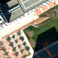 The wayfinding system is important for the people on campus. However, the existed wayfinding system of UBC does not consider some walkable paths which are not shown on the street map. Also, the wayfinding system ignores the barriers like stairs, which could be obstacles for wheelchair users, on the paths. LiDAR is developed rapidly in recent years. It can collect the elevation information of the objectives on the ground. University of British Columbia (UBC) collects and publishes the LiDAR dataset of campus every year. This project uses the elevation and the point intensity information from the LiDAR point dataset to identify the walkable paths and the barriers on the paths.
 Understanding temporal and spatial variations in environmental conditions is important for determining how urban forests affect ecological communities at the local scale. This study aims to use LiDAR data to investigate how shading and cooling affect urban forests at the UBC Vancouver campus within an ecosystem services framework.
 Growing urbanization and increased rainfall from climate change are compounding to create high flood risks for urban areas. As the University of British Columbia looks to create a sustainable campus, there are emerging questions of how to improve its stormwater resilience and reduce future flooding. This project uses a GIS rainfall-runoff analysis to assess the comparative performance of potential green infrastructures on campus. By optimizing the design and implementation of green infrastructures, campus planning can successfully enhance UBC’s stormwater resilience, mitigating the combined effects of urbanization and climate change.
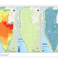 In response to growing concerns about climate change, recent studies have investigated the climate change impact on shifting precipitation and storm events. This study expands on this body of work through various analyses using the data from the Environment and Climate Change Canada (ECCC) and UBC Abacus Data Network to understand the effects of shifting precipitation regime on green infrastructure management at the UBC Point Grey campus. Results showed that the existing green infrastructure at UBC is not designed to handle large volumes of precipitation, leading to flooding and erosion risks. This highlights the need for sustainable stormwater management practices that consider each location’s unique characteristics. Several recommendations were made, such as balancing permeable and impermeable surfaces, installing and upgrading green roofs and other green infrastructure, and recording and updating related climate data and performance.
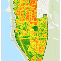 UBC Vancouver campus is interested in improving its ecological, soil, and shade connectivity, as these factors influence student and environmental health. Satellite imagery and data from UBC Campus and Community Planning were used to analyze ecological, shade and soil connectivity on campus. Ecological connectivity was lower in the northeastern portion of campus. Specifically, there were fewer trees, and they were more spread out. Shade connectivity was higher in the north part of campus with buildings and trees. Shade connectivity was the lowest in the southern part of campus with more open fields. Soil connectivity was the highest in southern campus, as there were more fields. Soil connectivity was the worst in the north section of campus as there was more built infrastructure. Planting tree species that are more suitable for future climates and maintaining high levels of connectivity will improve landscape resiliency. To maintain the history of a landscape, a portion of land can be reserved for endemic species where their connectivity is maintained to a high level. Increased maintenance could help endemic species survive, and limiting the species to a section of land would keep maintenance costs as low as possible. Improving soil connectivity would improve soil health, allowing for more and healthier trees, which in turn would improve shade connectivity, helping to maintain thermal comfort.
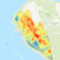 Urban greenery is crucial in mitigating climate change issues by influencing temperatures in cities. This study investigated how urban greenery coverage affected land surface temperature and air temperature at the University of British Columbia in July and August 2022. The study calculated land surface temperature from Landsat images and collected air temperature data from available sensors. Two linear regression models were built to illustrate relationships between urban greenery coverage and land surface temperature and air temperature respectively. The results revealed that the land surface temperature reduced with the increasing percentage of urban greenery coverage. Deciduous trees showed the strongest ability to reduce land surface temperature, followed by modified grass-herb and coniferous trees. Barren land had the highest land surface temperature. There was no significant relationship between urban greenery coverage and air temperature. This study provided valuable information for urban planners and policymakers to design and implement effective green space strategies to address climate change and human thermal comfort issues.
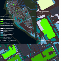 Green roofs are a promising mitigation tool against environmental concerns caused by increased urbanization. This study aims to address which of the University of British Columbia’s buildings are most suitable for a retrofitted green roof using active remote sensing. Through the assessment of the six characteristics of buildings, a suitability score was given to all the buildings within the area of interest on campus. The six suitability criteria are roof slope, rooftop area, building usage, building ownership, structural materials, and light intensity. The building suitability analysis resulted in the detection of five buildings with the greatest suitability score and their total rooftop area being 31,940.80 m2. Each of the five buildings then was further investigated in terms of the vegetation health and density surrounding the buildings to isolate potential concerns of planting in the area. Implementing green roof retrofitting on the suitable UBC buildings requires an additional accessibility analysis to maximize the positive social impacts of increasing campus greenery and make decisions on the green roof structure.
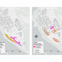 Habitat fragmentation has become an increasing threat to biodiversity. To address this problem, landscape connectivity modelling has become a popular method for identifying key areas for conservation efforts. This study assessed the habitat connectivity of two species, coyotes (Canis latrans) and brown creepers (Certhia americana), on UBC Vancouver campus using Conefor 2.6 and Conefor Inputs Tool. The land cover and Metro Vancouver data were used to identify habitat types and patch sizes needed by each species. Key and hub patches for each species were identified using spatial prioritization and evaluated their connectivity using the probability of connectivity (PC) values. The results showed that both species shared some important areas of connectivity, but brown creepers had a more connected network, while coyotes had higher key and hub patches. Areas of high and low connectivity for each species were also found to be affected by factors such as buildings and proximity to green spaces. The study highlights the importance of considering the specific habitat requirements of different species in conservation efforts and emphasizes the need to prioritize the conservation of key and hub patches for maintaining habitat connectivity and ensuring the survival of multiple species.
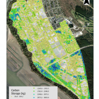 Urban forestry is a crucial tool for mitigating the impacts of climate change and enhancing people’s quality of life. Previous studies have shown that urban forests provide a wide range of ecosystem services. However, precise estimation of urban tree carbon storage remains a key challenge for effective urban forest management and planning. In this work, we investigated the carbon storage of trees on the UBC Vancouver Campus using 2018 LiDAR data. The aim was to determine the total carbon storage and the average carbon density of UBC campus. Tree height and structure were estimated using an existing model. The results revealed that the UBC Vancouver Campus has a total carbon storage of 24.63 Gg and an average carbon density of 6.13 kg m-2. These findings emphasize the significant role urban forests play in climate change mitigation and urban life improvement. Employing LiDAR data in conjunction with the existing model proved to be an efficient and effective method for estimating urban tree carbon storage. The results inform urban planning and policy decisions, fostering the integration of urban forests into sustainable campus development.
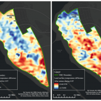 Rapid urbanization leads to the reduction of urban greenspaces, affecting the urban thermal environment and exacerbating the urban heat island effect. This study determined the spatial patterns of land surface temperatures and tree stand compositions, as well as examined the cooling effects of different tree stand compositions at the UBC Vancouver campus during the 2021 Western North America Heat Wave. This study was done by retrieving land surface temperatures from Landsat 8 images and using grid-based analysis to classify tree stand composition in the following classification schemes: coniferous, deciduous, and mixed wood. A linear mixed effects model was also conducted to quantify the relationship between land surface temperature differences and tree stand compositions throughout the Heat Wave. The results showed that coniferous stand composition was positively correlated, but deciduous stand composition was negatively correlated with land surface temperature differences. The findings indicated that expanding forested areas could lower land surface temperatures, and deciduous trees have the greatest cooling effectiveness. Overall, this study provided valuable insights into enhancing the resilience of the campus climate.
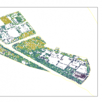 This study investigated the carbon sequestration rates of soft landscapes in the University of British Columbia Vancouver campus and compare their carbon sequestration capacity. The significance of carbon sequestration rates in soft landscapes is discussed in the context of urban planning and the role of vegetation in mitigating climate change. LiDAR data and aerial photos are used to estimate above-ground carbon sequestration, and GIS and R are used for data analysis. The research objectives are to compare the attributes of different soft landscapes, estimate their carbon sequestration rates, identify which soft landscapes have the highest carbon sequestration capacity, and discuss the limitations of the study and possible improvements for future research. The study aims to provide insights for optimizing urban soft landscape services to increase carbon storage in cities, and to explore the potential for incorporating soft landscapes as a sustainable urban infrastructure for carbon sequestration. Moreover, the findings may inform decisions regarding the implementation of sustainable landscape design of new and existing urban green spaces.
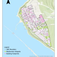 Pollination is an essential ecosystem service for crop production, where species such as insects and birds help to transfer pollen for plants to reproduce. Many of the pollinators are fully dependent on the plants and trees as their food sources and habitat. From a perspective of an urban planner, we must be able to recognize the values brought by pollinators to our ecosystems. Thus, we are attempting to discover the relationship between species and their habitats as much as possible.
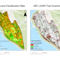 As urban forest provides ecological, social, and economic values to the residents, forest inventory can monitor forest health. Based on the land classification map, the campus planning team pays attention to tree health in the public green space of the University of British Columbia (UBC) campus in Vancouver, Canada. Working together, the forest inventory and land classification map are the priorities of urban planning and forest health in UBC. In order to solve the knowledge gap of no current inventory and land classification map on campus, this study aimed to update the UBC tree inventory and land classification map.
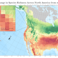 Climate change poses a considerable risk to forest diversity in urban communities. The University of British Columbia (UBC) seeks to identify vulnerable tree species on campus and apply strategies for sustaining arboreal diversity in future decades. In contribution to these efforts, this study investigated the potential shift in tree composition on the UBC Vancouver Campus over the next century by (1) predicting suitable climatic habitat for 128 campus species in 2050 and 2080, and (2) mapping the expected change in species richness across North America.
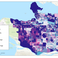 Urban vegetation acts as an extremely important carbon stock to store carbon. Although many studies have investigated the relationship between urban vegetation and carbon stocks, few of them closely examine the phenomenon of vegetation fragmentation in urban areas and how it affects the carbon stock. Therefore, this project investigates how vegetation fragmentation affects carbon stocks in the City of Vancouver using GIS analytic tools.
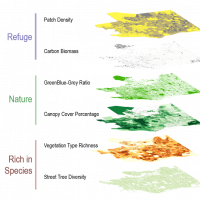 Living in cities can be stressful. While studies have shown that exposure to nature can help reduce stress and promote mental wellbeing, some research has shown that some characteristics of nature provide more psychological support than others depending on one’s state of wellbeing. City planning and urban forestry strategy need to consider the qualitative attributes of urban nature in the landscape in order to better support the different needs of the residents. This study focused on restorative nature: nature elements that help relieve stress and alleviate mental fatigue.
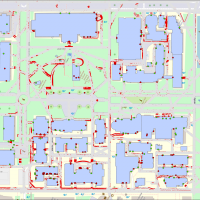 The purpose of this dataset is to allow for an accessibility analysis and mapping project to be conducted on the University of British Columbia (UBC), Vancouver Campus. In a university setting, campus navigation is a foundational part of seizing opportunities, networking with other scholars, and having an all-around positive student experience. Yet, inaccessible features of an urban landscape (like stairs, rough terrain, or steep slopes) often leave mobility-limited individuals at a great disadvantage or cut off from certain opportunities.
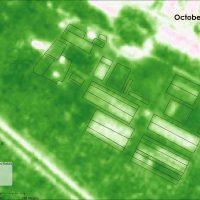 Remote sensing is an emerging tool in the agricultural sector with proven diverse applications, including monitoring indicators of soil health and crop productivity. These applications are currently predominantly limited to monocultural large-scale farms, and effectively monitoring small, diverse farms still presents many challenges. However, the high global prevalence of smallholder farms under diversified production warrants further research to expand the potential of remote sensing to small-scale farms.
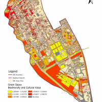 Due to the rapid growth of urbanization, species biodiversity is threatened and the innate relationship between humans and nature begins to fade gradually. Urban green spaces play a vital role in reconnecting human and urbanized landscape with its unique characteristics. Meanwhile, virtual gaming technology with applied geographic information has made a spectacular process to promote interactions between humans and their surroundings.