- Mapping the Unseen: Identifying Data Gaps and Proposing New Sampling Points in Northern Boreal Mountain Eco-province, BC Using K-Means Clustering and cLHS
Abstract This study investigates the soil variability within the Northern Boreal Mountains Ecoprovince in British Columbia, with a particular focus on wetland soils and soil organic carbon mapping. Utilizing the BCSOIL2020 dataset and an array of environmental covariates, we employed Principal Component Analysis (PCA), k-means clustering, and conditioned Latin Hypercube Sampling (cLHS) to develop a…
Read more: Mapping the Unseen: Identifying Data Gaps and Proposing New Sampling Points in Northern Boreal Mountain Eco-province, BC Using K-Means Clustering and cLHS
- Nature of War: The Political Ecology of the 2020 Nagorno-Karabakh Conflict
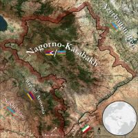
The Nagorno-Karabakh conflict has had profound consequences for both the political and physical geography of the South Caucasus region. Since the fighting of the 1990s there has been a relative status quo, with a militarised line of contact separating the two sides. This changed on September 27 2020, when intense fighting erupted along the whole of the front, and especially in the south-east. After a month and a half, fighting concluded on 10 November 2020 which saw the implementation of a ceasefire which ceded large portions of the Nagorno-Karabakh (Artsakh) Republic to Azerbaijan. There has yet to be an investigation on the kinds of changes to human and natural systems that the most recent conflict (2020) engendered. In response to this research lacuna, this paper asked whether the effects of the 2020 armed conflict had a significant effect on the region’s agricultural systems. This paper approached the question by examining per-pixel NDVI metrics – derived from Landsat 8 composites from April through June – before and after the conflict.
- Are Past Wildfire Activities Correlated with the Frequency of Different Types of Post-Wildfire Geomorphic Events such as Landslides and Debris Flows
Around the world, the frequency and intensity of wildfire events are rapidly increasing. Such a trend increasingly exposes some communities to the risk of the secondary hazards of wildfire, such as post-wildfire geomorphic events like a landslide and debris flow. To better manage the risk imposed by the secondary hazards of wildfire, a better understanding of the relationship between wildfire activities and the geomorphic events related therewith is necessary. In this paper, the temporal relationship between past wildfire events and the frequency of two different types of geomorphic events (landslides and debris flow) was studied statistically through the conduction of a time series analysis.
- Using Repeat-Pass Light Detection and Ranging (LiDAR) Data to Compare Wildfire Induced Geomorphic Change Across Different Burn Severities in the Cariboo Region, British Columbia
Wildfires remove vegetation and alter soil conditions resulting in increased susceptibility of ground surfaces to erosion, especially over periods of heavy precipitation. Geomorphic changes that are influenced by wildfire occurrence can evolve into hazardous natural events like landslides and flows that pose the risk of human fatality and costly infrastructural damage. We compare light detection and ranging (LiDAR) data time series to identify and compare landscape geomorphic change in burned and unburned areas in the William’s Lake area of the Cariboo Region of British Columbia following the 2017 wildfires.
- Estimating Productivity on the University of British Columbia (UBC, Vancouver Campus) Farm in 2019 using Normalized Difference Vegetation Index (NDVI) Time Series
Remote sensing is an emerging tool in the agricultural sector with proven diverse applications, including monitoring indicators of soil health and crop productivity. These applications are currently predominantly limited to monocultural large-scale farms, and effectively monitoring small, diverse farms still presents many challenges. However, the high global prevalence of smallholder farms under diversified production warrants further research to expand the potential of remote sensing to small-scale farms.
 The Nagorno-Karabakh conflict has had profound consequences for both the political and physical geography of the South Caucasus region. Since the fighting of the 1990s there has been a relative status quo, with a militarised line of contact separating the two sides. This changed on September 27 2020, when intense fighting erupted along the whole of the front, and especially in the south-east. After a month and a half, fighting concluded on 10 November 2020 which saw the implementation of a ceasefire which ceded large portions of the Nagorno-Karabakh (Artsakh) Republic to Azerbaijan. There has yet to be an investigation on the kinds of changes to human and natural systems that the most recent conflict (2020) engendered. In response to this research lacuna, this paper asked whether the effects of the 2020 armed conflict had a significant effect on the region’s agricultural systems. This paper approached the question by examining per-pixel NDVI metrics – derived from Landsat 8 composites from April through June – before and after the conflict.
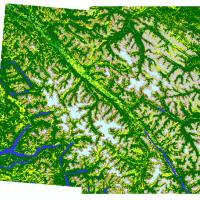 Around the world, the frequency and intensity of wildfire events are rapidly increasing. Such a trend increasingly exposes some communities to the risk of the secondary hazards of wildfire, such as post-wildfire geomorphic events like a landslide and debris flow. To better manage the risk imposed by the secondary hazards of wildfire, a better understanding of the relationship between wildfire activities and the geomorphic events related therewith is necessary. In this paper, the temporal relationship between past wildfire events and the frequency of two different types of geomorphic events (landslides and debris flow) was studied statistically through the conduction of a time series analysis.
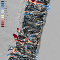 Wildfires remove vegetation and alter soil conditions resulting in increased susceptibility of ground surfaces to erosion, especially over periods of heavy precipitation. Geomorphic changes that are influenced by wildfire occurrence can evolve into hazardous natural events like landslides and flows that pose the risk of human fatality and costly infrastructural damage. We compare light detection and ranging (LiDAR) data time series to identify and compare landscape geomorphic change in burned and unburned areas in the William’s Lake area of the Cariboo Region of British Columbia following the 2017 wildfires.
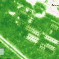 Remote sensing is an emerging tool in the agricultural sector with proven diverse applications, including monitoring indicators of soil health and crop productivity. These applications are currently predominantly limited to monocultural large-scale farms, and effectively monitoring small, diverse farms still presents many challenges. However, the high global prevalence of smallholder farms under diversified production warrants further research to expand the potential of remote sensing to small-scale farms.