- Mapping the potential loss and migration of mangroves in Northwest Madagascar due to sea level rise
Abstract Madagascar’s mangroves comprise 2% of the world’s total, but are at risk of loss due to increasing sea level rise (SLR). Vertical elevation gain (VEC) via sediment accumulation has historically allowed mangroves to adjust to SLR, but currently in many parts of the world, SLR is outpacing VEC. This study focuses on the Ambanja-Ambaro…
Read more: Mapping the potential loss and migration of mangroves in Northwest Madagascar due to sea level rise
- Predictive Ecosystem Mapping of the Chinchaga Watershed Management Basin, North Eastern British Columbia
Abstract The purpose of this project was to identify and map the location of wetlands in the Chinchaga Watershed Management Basin within the Fort St. John Timber Supply Area. The Chinchaga study area covers 75,000 hectares (ha), and serves as an ecologically significant unit within the Fort St. John Timber Supply Area, representing the gentle,…
Read more: Predictive Ecosystem Mapping of the Chinchaga Watershed Management Basin, North Eastern British Columbia
- Evaluating Landscape Metrics and Landcover Class Change at Rose Swanson Mountain
Landcover reflects distribution characteristics of surface vegetation, spatial differentiation and evolution across time. Controversial logging project that took place at Mount Rose-Swanson had raised concerns from the local community. Landcover maps and metrics can be used to study effects of human disturbances on the landscape. With the advancement of spatial pattern analysis program, ‘landscapemetrics’ package in R was used to quantify and investigate relationship between forest landcover and timber harvesting which occurred within. 35 high resolution annual forest landcover maps for Canada’s forested ecosystems from 1985 to 2019 inclusive were reclassified into five classes which are no change, shrubs, herbs, conifer and mixed wood.
- Post-Fire Mortality and Fire Resistance of Old-growth Forests in the Kootenay Lake Timber Supply Area, British Columbia
In an era of climate change, how different tree species in old forests are disturbed by wildfires, and what fire resistance they have are important questions. Old-growth forests are significant because they maintain local biodiversity and ecosystem sustainability, and also contribute to the local economy through timber harvesting. In this research, by analyzing Landsat-8 images of 20 fires from 2016 to 2020, the disturbance data of the forest before and after the fire can be generated. Data from B.C. government and Landsat-8 images are used to analyze fire resistance and recovery of old-growth forests in the Kootenay Lake Timber Supply Area (TSA) by calculating NBR (Normalized burn ratio) and NDVI (Normalized Difference Vegetation Index).
- Polygonization of discontinuous raster classes from machine-learning predictive ecosystem mapping (PEM)
Biogeoclimatic Ecosystem Classification (BEC) has been applied extensively in characterizing forested ecosystems in British Columbia. With a lack of qualified vectorization method used for BEC data transformation, the main goal of this research is to polygonize discontinuous BEC raster classes into vector map with better overall effectiveness and efficiency especially regarding the linear areas. The original data input for analysis is a machine-learning BEC zone raster map of Deception Study Area located in middle BC near Telkwa, with a resolution of 5m*5m. A comprehensive comparison between vectorization algorithms in GIS applications was conducted, including different filtering, simplifying and smoothing algorithms. Since we have the original predicted BEC raster map as the performance measurement, accuracy was directly measured as the percentage of correctly classified pixels when rasterizing the polygons.
- Rose Swanson Mountain, British Columbia – A Forest Health Assessment
Rose Swanson Mountain is an ecologically and culturally important forested region in the Northern Okanagan, British Columbia, Canada. In the summer of 2021, BC Timber Sales proposed eleven clear cut blocks on this area. Clear cut logging is a common practice in British Columbia, and while many studies have focused on recovery within the harvested areas, little research has analyzed the effects on the surrounding forest. Additionally, without localized scientific analysis, it is difficult for rural communities to preserve valued recreational areas on Crown land from logging. The goal of this study was to explore the trend in forest health and assess the effects of clear-cut harvesting on the immediately surrounding forest over time using freely available data and methods of analysis in order to empower rural communities to engage in their own assessments of local forests.
- How do shading and cooling of urban forests across the University of British Columbia Vancouver Campus affect building temperatures?
Understanding temporal and spatial variations in environmental conditions is important for determining how urban forests affect ecological communities at the local scale. This study aims to use LiDAR data to investigate how shading and cooling affect urban forests at the UBC Vancouver campus within an ecosystem services framework.
- Quantifying Upslope Treeline Advancement in the Mountainous Areas of the Cariboo Natural Resource Region, British Columbia, from 1985 to 2020
Upslope treeline advancement has been occurring globally over the last several decades, leading to displacement and fragmentation of alpine habitats and declines in species richness. Examining past and current treeline migration can provide insight into potential future conditions and can be used to improve ecosystem management. There is no long-term data on treeline advancement in Central British Columbia (B.C.) and the response to climate change is poorly understood. To address this, we explored treeline advancement in the Cariboo Natural Resource Region over a 35-year period (1985-2020) using Landsat imagery.
- Predicting Frost-Prone and Cold Air Accumulation Sites from DEMs
Increased deforestation in British Columbia from logging practices and wildfires has led to interests from the BC Ministry of Forests, Lands, Natural Resource Operations, and Rural Development to improve reforestation efforts province-wide. Modelling cold air and frost in BC has limited research prior to this project, and unexpected frost events in Spring and Autumn can have fatal effects to young, newly-planted trees in areas where frost develops on the landscape. The frost project is part of the greater Predictive Ecosystem Mapping project for BC on behalf of the ministry, and will contribute to improved land management practices.
- Within-Ecosystem Quantification and Comparison of Treeline Advancement in Cariboo Mountain, British Columbia
High elevation ecotones are susceptible to the rising temperature, under current climate change crisis. This paper aims to quantify the loss of alpine habitat to treeline advancement in the mountainous areas of the Cariboo Natural Resource Region. Specifically, this study focuses on comparing the patterns and rate of treeline advancement in the dry and wet subzones of Englemann Spruce – Subalpine Fir (ESSF) zone. Landsat 5 imageries and Digital Elevation Models are used to determine the treeline during 1985 – 2010.
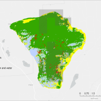
- Determining conservation priority areas for mangrove conservation and quantifying mangrove dynamics
The world’s mangroves forests are a critical resource to coastal communities, providing a plethora of ecosystem goods and services to millions of local peoples, while also being among the most carbon dense and biodiverse ecosystems in the world. To develop conservation initiatives local communities and NGO’s need a framework for determining priority conservation areas that accounts for anthropogenic pressure and carbon stocks, while also reflecting the values of local peoples. Here I document a method for determining priority conservation areas using a suitability analysis combining data sources on surrounding forest loss (Global Forest Change Database), mangrove loss (Global Mangrove Watch), soil carbon content (Global Mangrove Soil Database), and above ground biomass (Global Mangrove Above Ground Biomass Database) that was applied to 96 of Blue Ventures (BV) global locally managed marine areas.
- The Effects of Fuel Type Map Accuracy on Fire Behaviour Metrics
For fire managers and industry professionals, monitoring and leading wildfire prevention efforts as well as reactionary efforts require accurate and operable fuel type maps to achieve effective management. Fuel type map classification accuracy has been seen to have varying values across industries and applications (> 10 %), and the consequences of these misclassifications in fuel type mapping has yet to be determined. The objective of this research was to explore the effects of mapping error on fire behavior metrics, burn probability, fire intensity, and rate of spread in the southern interior forest region of British Columbia which experiences dry weather and extreme fire conditions.
- Developing a satellite-based frost risk model for the Northern British Columbia
Frost, as a frequent meteorological event in Canada, can significantly impact the yield of farm crops and fruit trees, and also causes cracking of infrastructure and damage to roads and buried pipelines. Knowing the potential frost sites for the Deception Lake Study Area in northern BC is important for studying forest loss and developing reforestation plans. The Moderate Imaging Spectrometer (MODIS) night-time land surface temperature (LST) products (spatial resolution: 1 km by 1 km) from the spring (March – May) and autumn (September – November) months between 2019 and 2021 were used for extracting temperature-related frost-risk variables, including minimum temperature, mean temperature, probability of frost occurrence, frost duration and frost severity index. K-means clustering was applied to cluster each variable into high-risk areas and low-risk areas, and four clusters were issued making pixels with 4 as the highest frost-risk pixels and 1 as the lowest risk.
- Exploring the Feasibility of Individual Tree Segmentation Algorithms on Terrestrial LiDAR Data
Abstract Terrestrial Laser Scanning (TLS) offers complementary and non-destructive methods for capturing three-dimensional information on forest structure. ITS is an essential process for modern forestry and ecological studies as it enables the precise isolation and characterization of individual trees from surrounding forest, facilitating critical analyses such as biomass estimation and advanced forest structure assessment. This…
Read more: Exploring the Feasibility of Individual Tree Segmentation Algorithms on Terrestrial LiDAR Data
- Comparative Analysis of Forest Canopy Height Estimation using Random Forest and Support Vector Machine Models with Synthetic Aperture Radar and Optical Imagery
Abstract In this study, the accuracy of forest canopy height estimation was assessed using Synthetic Aperture Radar (SAR), including backscatter and Polarimetric SAR (PolSAR), as well as optical indices derived from optical imagery, and Random Forest (RF) and Support Vector Machine (SVM) models were applied by using canopy heights derived from Light Detection and Ranging…
Read more: Comparative Analysis of Forest Canopy Height Estimation using Random Forest and Support Vector Machine Models with Synthetic Aperture Radar and Optical Imagery
- Comparing PolSAR, SAR and Optical Imagery Integration for Forest Canopy Height Estimation in Interior British Columbia, Canada
Abstract Forest canopy height is an important indicator for estimating forest carbon stock and biomass, which have implications for multiple environmental issues. In remote sensing, canopy height is most commonly measured using light detection and ranging (LiDAR), which comes with satisfactory accuracy but also high costs. This study looked at the potential of using synthetic…
Read more: Comparing PolSAR, SAR and Optical Imagery Integration for Forest Canopy Height Estimation in Interior British Columbia, Canada
- Modelling the Effects of Timber Harvest and Harvest Site Selection on Burn Probability
Abstract Climate change exacerbates wildfire risks globally, with projections indicating a significant increase in their frequency and severity. This study investigates the impact of timber harvesting on wildfire likelihood, focusing on the Mount Rose Swanson Sensitive Area (RSSA) in British Columbia, Canada. Using the Burn-P3 model, three scenarios were simulated: no harvest, harvest in high…
Read more: Modelling the Effects of Timber Harvest and Harvest Site Selection on Burn Probability
- Comparison Between Sentinel-2 and Landsat in Mapping Mangroves in The Gambia Using the Google Earth Engine Mangrove Mapping Methodology (GEM v2)
Abstract Mangroves play a vital role in coastal environments by supporting biodiversity, protecting shorelines, and storing carbon. However, these ecosystems are under growing pressure from land use change, development, and rising sea levels. Monitoring changes in mangrove cover is essential for guiding conservation and management efforts, but on the ground, methods are often time-consuming, expensive,…
Read more: Comparison Between Sentinel-2 and Landsat in Mapping Mangroves in The Gambia Using the Google Earth Engine Mangrove Mapping Methodology (GEM v2)
- Monitoring Mangrove Recovery in the Bay of Assassins, Madagascar
Abstract Mangroves are unique plant species that support livelihoods and provide critical ecosystem services. Globally, mangroves have faced significant threats from deforestation, causing rapid decline; however, recent restoration efforts have made a positive impact. Effective restoration requires regular monitoring and evaluation to ensure its long-term success. This study aims to support mangrove restoration efforts in…
Read more: Monitoring Mangrove Recovery in the Bay of Assassins, Madagascar
- Detecting Change of Aboveground Biomass (AGB) in Kwahu South, Ghana
Abstract Forest plays a vital role in regulating the global carbon cycle, yet their aboveground biomass (AGB) remains difficult to estimate over large areas due to limitations of field-based measurements. This study addresses the challenge by evaluating satellite-based approaches to estimate AGB in Kwahu South, Ghana. The objective was to determine which optical satellite imagery,…
Read more: Detecting Change of Aboveground Biomass (AGB) in Kwahu South, Ghana
- Modeling Tree Shade Coverage: Planting Recommendations for Optimizing Shade on the University of British Columbia Vancouver Campus
Abstract Tree shade in urban environments serves to improve human thermal comfort and building energy use during the summer months. Under future climates, tree shade becomes an even more important ecosystem service that promotes climate change resilience. Tree shade was modelled in order to optimize shade coverage on the University of British Columbia (UBC) Vancouver…
Read more: Modeling Tree Shade Coverage: Planting Recommendations for Optimizing Shade on the University of British Columbia Vancouver Campus
- Generating Synthetic Remote Sensing Data with Deep Learning for Improved Wetland Classification
Abstract Wetlands in the Prairie Pothole region of Canada are critical ecosystems that support biodiversity and provide essential ecosystem services, yet they face increasing threats from agricultural expansion and climate change. Remote sensing offers a powerful tool for monitoring these landscapes over time, enabling large-scale, consistent land cover classification compared to conventional field-based methods. However,…
Read more: Generating Synthetic Remote Sensing Data with Deep Learning for Improved Wetland Classification
- Estimating Above-Ground Biomass Using Remote Sensing and Machine Learning in Kwahu South, Ghana
Abstract Tropical forests in regions like Kwahu South, Ghana, are vital for mitigating climate change by storing carbon in aboveground biomass (AGB), but deforestation and land use changes, driven by agriculture and mining, threaten their role as carbon sinks. Accurate AGB estimation is crucial for conservation and sustainable land management, yet traditional field methods are…
Read more: Estimating Above-Ground Biomass Using Remote Sensing and Machine Learning in Kwahu South, Ghana
- Comparison of Methods of Multi-Source Remote Sensing Estimations of Aboveground Biomass of Tropical Rainforests in Kwahu South, Ghana
Abstract Aboveground biomass (AGB) is an important metric in forest carbon analysis, allowing for continuous monitoring of changes in biomass over time. Field measurements to provide accurate assessments of these metrics are cost and time-prohibitive, although remote sensing can gather this information quickly and more affordably, and with machine learning models they can achieve robust…
Read more: Comparison of Methods of Multi-Source Remote Sensing Estimations of Aboveground Biomass of Tropical Rainforests in Kwahu South, Ghana
- Visualize Six Years of Architectural Changes at the University of British Columbia Vancouver Campus: Impacts on Tree Growth, Green Connectivity, and Coyote Footprints
Abstract Urban development, such as campus expansion, alters land cover and disrupts ecological processes, but the full extent of these impacts is often underexamined at fine spatial and temporal scales. This study investigates how building expansion on the University of British Columbia (UBC) Vancouver campus from 2015 to 2021 has influenced tree dynamics and coyote…
Read more: Visualize Six Years of Architectural Changes at the University of British Columbia Vancouver Campus: Impacts on Tree Growth, Green Connectivity, and Coyote Footprints
- Evaluating Riparian Function Using LiDAR-Derived Vegetation Intactness and Cattle Accessibility in the Cariboo Region, British Columbia
Abstract Riparian zones provide vital ecological services, such as maintaining water quality, supporting biodiversity, and stabilizing stream banks; however, these areas in British Columbia’s Cariboo Natural Resource Region are increasingly pressured by forestry practices, cattle grazing, and private land management. Traditional cumulative effects assessments rely predominantly on indirect indicators of disturbance potential, which may inaccurately…
Read more: Evaluating Riparian Function Using LiDAR-Derived Vegetation Intactness and Cattle Accessibility in the Cariboo Region, British Columbia
- Replication Data for: Evaluating Carbon Baselines in Kwahu South: A Comparison of VM0047 and Open Forest Protocol
Abstract Forests are essential for climate change mitigation, acting as carbon sinks by absorbing carbon dioxide. Remote sensing, particularly through Landsat 8’s 30m resolution imagery, facilitates consistent, large-scale monitoring of forest cover and biomass changes, crucial for precise carbon stock assessments in reforestation efforts. However, differences in baseline estimation methodologies complicate these evaluations. This study…
Read more: Replication Data for: Evaluating Carbon Baselines in Kwahu South: A Comparison of VM0047 and Open Forest Protocol
- Tracking Forest Recovery: Early Indicators of Forest Regeneration Following the 2017 Elephant Hill Wildfire in British Columbia, Canada
Abstract Wildfire is an increasingly prominent disturbance across forested landscapes in British Columbia, yet ecological responses and long-term vegetation recovery remain complex and spatially variable. This study investigates post-fire vegetation recovery following the 2017 Elephant Hill wildfire using Landsat-derived remote sensing data from 2015 to 2022. By analyzing the Normalized Burn Ratio (NBR) and Normalized…
Read more: Tracking Forest Recovery: Early Indicators of Forest Regeneration Following the 2017 Elephant Hill Wildfire in British Columbia, Canada
- Integrating LiDAR (Light Detection and Ranging) and Camera Traps to Assess the Influence of Three-Dimensional Forest Structure on Mammal Habitat Use in Coastal Western Hemlock Forests
Abstract Global forest degradation and habitat loss caused have induced the need for advanced methods to assess forest quality and how would these change impacts on animals. Although extensive research has focused on responses of birds to habitat change, the influence of forest structure on mammals has remained underexplored. In southwestern British Columbia, Malcolm Knapp…
Read more: Integrating LiDAR (Light Detection and Ranging) and Camera Traps to Assess the Influence of Three-Dimensional Forest Structure on Mammal Habitat Use in Coastal Western Hemlock Forests
- Supervised Mangrove Classification in Madagascar Comparing Optical Imagery to Combined Optical and Synthetic Aperture Radar Imagery Using Random Forest on Sentinel-1 and Sentinel 2
Abstract Mangrove ecosystems are critical coastal habitats that provide essential services such as shoreline protection, carbon sequestration, and biodiversity support. Monitoring these ecosystems over large and often remote areas can be challenging, making remote sensing a valuable tool for effective observation and management. However, accurate classification of mangroves remains difficult due to spectral and structural…
Read more: Supervised Mangrove Classification in Madagascar Comparing Optical Imagery to Combined Optical and Synthetic Aperture Radar Imagery Using Random Forest on Sentinel-1 and Sentinel 2
- Influence of Aspen Serpentine Leafminer (Phyllocnistis populiella) on Burn Severity In Trembling Aspen (Populus tremuloides)
Abstract Trembling aspen (Populus tremuloides) is a fire-resilient tree species, making its role increasingly important as wildfire seasons intensify in British Columbia, Canada. However, forest pests like the aspen serpentine leafminer (Phyllocnistis populiella) raise concerns about their potential to alter fire behavior by affecting forest structure and fuel conditions. This study evaluates whether leafminer outbreaks…
Read more: Influence of Aspen Serpentine Leafminer (Phyllocnistis populiella) on Burn Severity In Trembling Aspen (Populus tremuloides)
- Land Cover Mapping in Cable Bay with Sentinel 2 from 2018 to 2024
Abstract The Cable Bay area, south of Nanaimo, British Columbia, is an ecologically rich region with diverse ecosystems, including rare Garry oak meadows, increasingly threatened by urban expansion. This study mapped and analyzed land cover changes across six classes—Broadleaf, Conifer, Cropland, Developed, Meadow, and Water—from 2018 to 2024. We applied a Random Forest classifier to…
Read more: Land Cover Mapping in Cable Bay with Sentinel 2 from 2018 to 2024
- Assessing Baseline and Monitoring Change in Forest Carbon Projects
Abstract This study evaluates carbon stock changes in the Northern Scarp West Forest Reserve (project site) and Bumfuom Forest Reserve (control site) in Ghana, using remote sensing techniques and biomass estimation methodologies. The aim is to compare two carbon crediting frameworks Gold Standard V2.1 and Verra VM0047 in terms of their effectiveness in monitoring carbon…
Read more: Assessing Baseline and Monitoring Change in Forest Carbon Projects
- Combining Multi-Season Multispectral Imagery and Airborne Laser Scanning Data to Improve Predicted Quercus garryana Distribution
Abstract Garry oak ecosystems are one of North America’s most distinctive and ecologically significant ecosystems. Currently, only 1–5% of their historical extent remains in near-natural condition. Effective conservation requires accurate information on Garry oak distribution and forest composition. Remote sensing and machine learning offer advantages over traditional methods in terms of resources and scalability. Spectral…
Read more: Combining Multi-Season Multispectral Imagery and Airborne Laser Scanning Data to Improve Predicted Quercus garryana Distribution
- Mapping Equity Access to Green Spaces Across The University of British Columbia Vancouver Campus
Abstract Green spaces play an important role in providing ecosystem services such as air purification, temperature regulation, and recreational opportunities; however, their unequal distribution often highlights environmental inequities. This study examines the spatial distribution of green space coverage across the University of British Columbia (UBC) Vancouver campus to identify areas with limited access, termed Equity…
Read more: Mapping Equity Access to Green Spaces Across The University of British Columbia Vancouver Campus
- Applying Declassified Cold War Intelligence Imagery for Long-Term Forest Cover Change Analysis
Abstract Land cover change analysis using satellite imagery is constrained by the availability and range of historical data, with programs like Landsat offering data only from the 1980s onward. Furthermore, the 30-meter resolution of these datasets makes it challenging to distinguish fine-scale land cover variability in heterogeneous landscapes. This study addressed these limitations by utilizing…
Read more: Applying Declassified Cold War Intelligence Imagery for Long-Term Forest Cover Change Analysis
- Climate adaptation scenarios for a resilient future at University of British Columbia Botanical Garden: Modeling 4 Species of Acer (Maple)
Abstract As anthropogenic climate change continues to disrupt forests and species’ ecological niches, there is increasing urgency to create plans surrounding adaptation and mitigation for especially vulnerable species. The University of British Columbia’s Botanical Garden (UBCBG) wants to understand species responses to climate change and whether species within their collection will be able to survive…
Read more: Climate adaptation scenarios for a resilient future at University of British Columbia Botanical Garden: Modeling 4 Species of Acer (Maple)
- Comparing the Accuracy of Polarimetric Synthetic Aperture Radar (PolSAR) Canopy Height Models for Forests in the Pacific Maritime and Montane Cordillera Ecozones
Abstract Land management practices increasingly depend on detailed forest structure information, including canopy height, necessitating the adoption of advanced remote sensing methodologies. This research contributes to meeting this demand by leveraging polarimetric synthetic aperture radar (PolSAR) data, integrated with multispectral imagery, to model forest canopy height in the Pacific Maritime and the Montane Cordillera ecozones…
Read more: Comparing the Accuracy of Polarimetric Synthetic Aperture Radar (PolSAR) Canopy Height Models for Forests in the Pacific Maritime and Montane Cordillera Ecozones
- Impact of Forest Age and Forest Type on the Accuracy of Canopy Height Estimation by Synthetic Aperture Radar and Optical Imagery
Abstract Forest canopy height measurement is critical for forest resources management, several remote sensing techniques have been applied to estimate the canopy height, including Light Detection and Ranging (LiDAR). However, the limited publicly available LiDAR data in British Columbia, limitation by clouds, and the cost create some challenges. To overcome this issue, this study employed…
Read more: Impact of Forest Age and Forest Type on the Accuracy of Canopy Height Estimation by Synthetic Aperture Radar and Optical Imagery
- Monitoring mangrove reforestation in Madagascar with Sentinel 2 derived spectral indices
Abstract Mangroves play a crucial role in carbon sequestration, coastal protection, and biodiversity. The efficacy of mangrove reforestation projects is important for environmental management and conservation efforts around the world. This study evaluates the use of spectral indices derived from Sentinel-2 data to monitor mangrove reforestation. Specifically, Normalized Difference Vegetation Index (NDVI), Enhanced Vegetation Index…
Read more: Monitoring mangrove reforestation in Madagascar with Sentinel 2 derived spectral indices
- Hotspot analysis for mangrove restoration suitability
Abstract This research paper presents a globally replicable methodology for subnational hotspot analysis of mangrove restoration suitability. The study utilized Central America as a focal area and employed a two-phase workflow involving scripted analysis in RStudio and non-scripted application of QGIS geoprocessing tools and qualitative assessment. Approaches to spatially defining mangrove areas for analysis were…
Read more: Hotspot analysis for mangrove restoration suitability
- Using LiDAR to characterize urban forest structure and composition and locate hotspots based on derived individual tree attributes
Abstract This study provides urban forest tree inventories for the University Endowment Lands, Pacific Spirit Regional Park, Musqueam First Nation, and Southlands of British Columbia for 2015 and 2021. It describes urban forest structure and composition based on LiDAR-derived urban forest attributes including tree count, maximum height (zmax), crown area, and species type (coniferous/broadleaf). Hotspot…
Read more: Using LiDAR to characterize urban forest structure and composition and locate hotspots based on derived individual tree attributes
- Using LiDAR-based Inventories to Evaluate the Impact of Silvicultural Practices on Forest Biomass
Abstract Forests are crucial in absorbing and storing carbon in land-based ecosystems, and their proper management is essential for mitigating climate change. This study assesses the influence of silvicultural systems on the amount of forest carbon in the Boundary Timber Supply Area (TSA) located in BC. The evaluation is based on enhanced forest inventories conducted…
Read more: Using LiDAR-based Inventories to Evaluate the Impact of Silvicultural Practices on Forest Biomass
- Integrating Hydrological Modeling for Sustainable Forest Management: Rose Swanson Mountain, British Columbia
Abstract The aim of this research was to identify hydrologically sensitive areas (HSAs) on Rose Swanson Mountain, British Columbia. The region of interest is operating as a timber harvesting area for British Columbia Timber Sales (BCTS) without a comprehensive hydrological map. The absence of this hydrology map puts the topography at risk of forest fires,…
Read more: Integrating Hydrological Modeling for Sustainable Forest Management: Rose Swanson Mountain, British Columbia
- Exploring Potential Benefits of Visualizing Canopy Cover Change in 3D Gaming Engine Environment
Abstract This research explores the innovative use of a 3D gaming engine, Minetest, for visualizing changes in canopy cover change at the University of British Columbia (UBC) campus, addressing the pressing challenge of urban expansion on green spaces. We compared and visualized canopy height change for UBC campus in both 2D traditional environment and 3D…
Read more: Exploring Potential Benefits of Visualizing Canopy Cover Change in 3D Gaming Engine Environment
- Mapping Species at Risk and of Cultural Value in Campbell River Regional District, British Columbia
Abstract In the face of rapidly declining biodiversity and the increasing fragmentation of habitats, identifying and prioritizing conservation areas have become crucial challenges for environmental sustainability. This study seeks to address these challenges by leveraging the power of citizen science data from iNaturalist and integrating it with GIS technology to assess conservation priorities in Campbell…
Read more: Mapping Species at Risk and of Cultural Value in Campbell River Regional District, British Columbia
- Deriving LiDAR Metrics for Forest Structure Mapping in Wildfire Risk Assessment
Abstract The escalating incidents of wildfire pose a critical challenge in Canada, necessitating an understanding of forest structures for the effective implementation of fuel treatment strategies to mitigate wildfire risks. While previous research has explored forest structures and wildfire risk, a gap remains in translating these studies into operational solutions for foresters and land managers.…
Read more: Deriving LiDAR Metrics for Forest Structure Mapping in Wildfire Risk Assessment
- Comparing the Impact of Hurricane Rai on Two Mangrove Forests in the Philippines
Abstract Mangrove ecosystems are vital to coastal communities by providing a variety of crucial ecosystem services including the providing of fish stocks, building materials and firewood; the storing of large amounts of carbon; and the sheltering of coastal communities from tropical storms. For many decades, human activities have led to the degradation of these mangrove…
Read more: Comparing the Impact of Hurricane Rai on Two Mangrove Forests in the Philippines
- Mangrove mapping in Saloum Delta, Senegal using Google Earth Engine Mangrove Mapping Methodology (GEEMMM
Abstract Mangroves provide crucial biodiversity values to the ecosystem and the carbon dioxide sequestration capacity of mangrove forests helps mitigate global climate change. Given the diverse ecosystem and economic values, mapping how mangroves change over time is important for mangrove forest management and protection. The traditional mangrove mapping methodology using remote sensing requires a comprehensive…
Read more: Mangrove mapping in Saloum Delta, Senegal using Google Earth Engine Mangrove Mapping Methodology (GEEMMM
- A Climate Suitability Analysis for Western Hemlock: Modeling Future Occurrence Probability of Tsuga heterophylla at the UBC Vancouver Campus
To better manage green spaces in the face of climate change, the Social Ecological Economic Development Studies program of the University of British Columbia (UBC) organized a series of projects to predict the climate suitability of common tree species at Vancouver campus by 2100. Coniferous trees are vulnerable to changing precipitation and temperature. Western hemlock (Tsuga heterophylla) is a common coniferous tree species at UBC Vancouver campus and was chosen to be analyzed in this study. Climate suitability analysis was done using a MaxEnt model. As a machine-learning algorithm not requiring data about absent points, MaxEnt is considered to be a good tool for predicting the distribution of species. There were 19 bioclimatic variables tested in the analysis, and the precipitation in the coldest quarter of the year was determined to be the most important climatic variable affecting the growth of Western hemlock. The results showed that the occurrence probability of Western hemlock would drop from its current ~87% to ~10% under one of the most likely climate models in 2100. Although this result could not represent the real occurrence probability of Western hemlock by the end of the century due to the limited data and variables considered, this study provided a reference for future climate suitability analysis for other tree species and could potentially help with the protection of existing Western hemlock on campus.
- Old-Growth Attributes Prediction in the Coastal Western Hemlock Ecosystem, British Columbia using LiDAR
Old-growth forests have complex structures that provide critical habitat for endangered species and enhance biodiversity and ecosystem services. Old-growth forests have become rare due to harvesting. In order to support the recovery process of old-growth forests in British Columbia, it is valuable to identify old-growth characteristics in recovering forests for conservation purposes. This study attempted to predict the distribution of old-growth attributes in the Coastal Western Hemlock (CWH) zone in British Columbia using area-based LiDAR metrics. LiDAR point clouds of 61 forestry inventory plots were extracted to generate LiDAR metrics to create multilinear regression models for four old-growth attributes: standard deviation of diameter at breast height (DBH), maximum tree DBH, average live crown percentage, and the sum of understory plants percentage. The results showed the ability of LiDAR to predict varied by old-growth attributes and were highest for the standard deviation of DBH, followed by Maximum Tree DBH, the Sum of understory plants percentage and lowest for average live crown percentage. An old-growth index was derived from four old-growth attributes for mapping the potential locations of old-growth. However, the validation results of 19.08% from vegetation resource inventory (VRI) illustrate that the old-growth index does not successfully identify old growth. Despite the challenges, the prediction results can still be used to identify old-growth attributes and enhance knowledge of old-growth landscapes. Also, this study has potential applications in old-growth forest restoration and supports government’s old-growth management plans.
- Using Planet data to classify mangrove subtypes in Northwestern Madagascar in 2020 and 2022
In response to the growing concerns about mangrove deforestation, recent studies have used various remote sensing technology to measure the mangrove extent. In this work, we investigated the mangrove distribution in Northwestern Madagascar by using fine spatial imagery with a pixel size as small as 3m and compared it with the result of the traditional method based on relatively coarser Landsat data. The quantitative result central to this work is the new multi-date map of the Tsimipaika- Ampasindava-Ambaro Bays (TAB) from 2020 to 2022, which provides advanced detail and direct comparison with the shift in local mangrove species. The classification maps are based on Random Forest and Maximum Likelihood algorithms, and all of them have an overall accuracy of over 85%. The dynamics of mangrove forests from 2020 to 2022 are quantified, with a 12.6% loss in closed-canopy mangroves, and a 24.1% loss in open-canopy mangroves. Limitations regarding the classification model include the overestimation of open canopy mangroves caused by the shadow and the seamline in the base map. This result shows the potential of using fine-resolution satellite imagery in supervised land cover classification, and the corresponding challenges raised by the smaller pixel size.
- Metrics of Change: Informing Ecological Restoration by Quantifying Landscapes and Processes in Banff National Park
The landscapes in the Rocky Mountain Cordillera undergo constant change due to the intricate interplay of ecological processes, with fire being the primary disturbance agent. Fire suppression policies have impeded the ecological role of fire, resulting in increased conifer forest dominance and declines in landscape heterogeneity. The objective of this study was to develop a methodology to accurately measure regional landscape changes resulting from fire suppression and fire restoration in Banff National Park, with the goal of supporting data-informed resource management. A landscape metrics approach was selected to investigate changes across 27 management units. Four landscape metrics were calculated using annual land cover maps derived from Virtual Land Cover Engine/Landsat-5/7 imagery spanning 34 years (1984-2019). Metrics were selected to capture conifer encroachment (proportion of conifer class) and landscape heterogeneity (contagion, edge density, Shannon’s diversity index) changes. Time-series analysis and Thiel-Sen slope estimation were used to identify metric trends. The study’s resulting metrics offer resource managers additional landscape attributes to compare and monitor management units, which can support decision-making, prioritize fire restoration and inform future ecological studies.
- Mapping the Historical Trails of Rose Swanson Mountain
In response to growing concerns about the limited accessibility and preservation of historical trails at Rose Swanson Mountain, this study uses aerial photos and GIS to digitize these trails. Our goal is to create a comprehensive and accurate digital map of the trails while examining the impact of logging and forest fires on their length and location. The results indicate that the total length of the trails in Rose Swanson Mountain has significantly decreased due to logging activities and regulations set by the BC Ministry of Forestry. Additionally, we found that most of the existing trails are located within a sensitive area. Our study also highlighted the limitations of using aerial photography for digitizing historical trails, including the difficulty of identifying trails from air photos and the accuracy of the georeferencing process. The digital map of the historical trails can significantly contribute to the preservation of local indigenous culture and promote sustainable forest management practices that consider both economic benefits and ecological benefits. Our findings can guide policymakers in assessing the impact of logging on forests near Canadian indigenous traditional community areas and implementing regulations to mitigate these effects. Future studies can explore the benefits of preserving the forest and historical trails, such as the forest’s carbon storage potential and the economic contribution of the trail system to the local economy.
- Mangrove mapping along the Lower Casamance River in Senegal, using the Google Earth Engine Mangrove Mapping Methodology (GEEMMM)
Mangrove forests are highly productive, complex coastal ecosystems that shelter a diverse range of species and offer important ecological services. In recent decades, mangrove forests in Africa have been experiencing drastic degradation and decline in population due to heavy anthropogenic pressures and climate change-induced sea level rise. To ensure the future long-term well-being of these unique ecosystems, and to reflect past conservation efforts, quantitative analysis of the past and current mangrove forest condition on a regional scale is much needed. This study systematically mapped mangrove forests along the Lower Casamance River region, using Google Earth Engine Mangrove Mapping Methodology (GEEMMM), for the years 1990 and 2021. Overall, we achieve a validation accuracy of 87.13% for the 2021 classification and 90.25% for the 1990 classification. Our study found that, across our study regions, there was a net loss of 123.99 km2 in our open-canopy mangrove I class and a net gain of 63.04 km2 in our closed-canopy mangrove class. This suggested that while some areas had seen a slight increase in mangrove populations either due to natural regeneration or ongoing conservation efforts, the overall mangrove forests had experienced major degradation. Furthermore, the majority of the loss happened within 10km of the shoreline, suggesting that fishing activity might be one of the biggest contributors to mangrove forest loss.
- Decadal Grid Analysis of Landscape Metrics for Provincial Parks of British Columbia
Provincial parks of British Columbia are protected for their high ecological, cultural, and recreational values. With climate change exacerbating, more frequent and severe disturbances are anticipated to cause land cover alteration in park ecosystems, leading to loss of habitat and ecosystem services. It’s crucial to understand how landscape configurations changed in the past to make informed conservation efforts. Using the landscapemetrics package in R, this project quantitatively analyzed the landscape configuration of forests and shrubs on 1 km by 1 km grids in a time step of decades from 1989 to 2019 for E. C. Manning Park, Mount Robson Park, Tweedsmuir Park, and West Arm Park. The metrics were tested to compare and characterize grids along the park boundary versus the interior. The metrics highlighted the spatial distribution and shape complexity of forests and shrubs and the time frames during which noticeable land cover changes occurred. The results provided spatial, temporal, and statistical insight into landscape dynamics over the decades. They showed that future park management could benefit from accounting for the spatial variation of the park landscape by developing targeted restoration strategies.
- Predicting Forage Availability from Open Source LiDAR Data
Livestock forage availability is an important factor when allocating land for grazing animals. Due to the variation in British Columbia’s topography and plant communities, rangeland management faces unique challenges with natural resource operations and rural development. The goal of this study was to create a predictive model of forage availability using light detection and ranging (LiDAR) data from the Open LiDAR Data Portal and biometric ground truthing data from the Vegetation Resource Index.
- Development of Interactive Data Visualization Tool for the Predictive Ecosystem Mapping Project
Biogeoclimatic Ecosystem Classification (BEC) system is the ecosystem classification adopted in the forest management within British Columbia based on vegetation, soil, and climate characteristics whereas Site Series is the smallest unit of the system. The Ministry of Forests, Lands, Natural Resource Operations and Rural Development held under the Government of British Columbia (“the Ministry”) developed a web-based tool known as BEC Map for maintaining and sharing the information of the BEC system, but the Site Series information was not included in the tool due to its quantity and complexity. In order to allow users to explore and interact with the information, this project aimed to develop a web-based tool with high data quality and flexibility to users for the Site Series classes using the “Shiny” and “Leaflet” packages in R.
- Understanding Microclimate in University of British Columbia’s Botanical Garden
Climate change is a key factor in how extreme weather events affect how ecosystems and species react to these changes in temperatures. University of British Columbia’s (UBC) Botanical Garden is interested in improving microclimate information within the garden to understand how areas with shade create respite zones for species. Due to the recent extreme weather temperatures in Vancouver, the garden is interested in how to continue to adapt and mitigate to these extremes. Microclimates are important as they are cooler temperatures beneath the canopy. Looking at how canopy cover influences land surface temperature can give insight on microclimates. Using LiDAR metrics to calculate canopy cover and Landsat to calculate land surface temperature, a model was built to understand the significance of canopy cover and land surface temperature, with the addition of other LiDAR metrics.
- Comparing the Level of Above-ground Carbon Sequestration and Respective Ecosystem Services between Native and Cultivated Trees in the University of British Columbia Botanical Garden
Urban trees play an essential role in alleviating the local effects of global warming by sequestering atmospheric carbon dioxide, regulating temperature and reducing air pollution in urban areas. There have been studies estimating carbon sequestration of urban trees using Light Detection and Ranging (LiDAR). Yet, neither of the studies made comparison between species nor extended the discussion towards ecosystem services. Therefore, this study compared the attributes between native and cultivated trees in the Asian Garden of the University of British Columbia (UBC) Botanical Garden, estimated their level of above-ground carbon sequestration, and thus examined respective implications in terms of ecosystem services.
- Snag Detection In The Interior Douglas-Fir Zone Of British Columbia Using Area-Based Lidar Metrics
Snags (dead standing trees) form an important structural aspect of a forest and perform many essential ecological functions such as habitat provision. As such, substantial research has investigated various methods of snag detection using lidar. One approach is to compute areal lidar metrics such as slope, elevation, canopy height, etc. to detect snags. However, it remains unclear which lidar metrics are best suited for snag detection. This study attempted to predict snag presence/absence and density in the Interior Douglas-Fir (IDF) zone in British Columbia using area based lidar metrics.
- Climate adaptation scenarios for a resilient future at University of British Columbia Botanical Garden: Modeling 4 Species of Acer (Maple)
As anthropogenic climate change continues to disrupt forests and species’ ecological niches, there is increasing urgency to create plans surrounding adaptation and mitigation for especially vulnerable species. The University of British Columbia’s Botanical Garden (UBCBG) wants to understand species responses to climate change and whether species within their collection will be able to survive in the Garden, given the effects of climate change. One especially important collection UBCBG curates is maple (Acer) trees, currently leading the global consortium of Acer and housing over 50 different species. This study examined the survival probability of four Acer species UBCBG curates including: five-fingered Maple (Acer pentaphyllum Diels), considered critically endangered; paperbark/bloodbark Maple (Acer griseum (Franch.) Pax), considered endangered; bigleaf maple (Acer macrophyllum Pursh), not endangered; and vine maple (Acer circinatum Pursh), not endangered.
- Burn-P3 modelling of fire behaivour on Rose Swanson Mountain, British Columbia before and after harvesting
It has been long known that wildfire and harvesting can have a relationship. However, this relationship is not straightforward and well understood. In this paper, we hope to quantify the impact of proposed harvesting on the wildfire severity and probability on Rose Swanson Mountain. Rose Swanson Mountain is a small mountain in South Central BC near the town of Armstrong used by the locals for its bountiful outdoor recreation. In early 2020 British Columbia Timber Sales added part of the Rose Swanson Mountain Sensitive Area to its list of soon-to-be harvested areas. This paper illustrates the research done in BurnP3 and ArcPro to simulate and measure fire in a pre and post logged Rose Swanson.
- Evaluation of snag density and snag metrics in Old Growth Deferral Priority Areas in the Cariboo region using airborne LiDAR data
Standing dead trees (snags) are crucial habitats for fauna in mature and diverse forests along the Interior Douglas-fir Zone of British Columbia. The objective of this study is to evaluate whether snag density and snag metrics differ between three categories of at-risk and irreplaceable Old Growth Priority Deferral Areas (ancient, big-treed and remnant) and their neighbouring areas with no deferral status. Using airborne LiDAR data, we detect snags using 1) area-based forest metrics paired with random forest modelling, and 2) an individual snag detection algorithm.
- Using SAR Imagery to Assess Forest Distribution on a Cloudy Tropical Island
Tropical forests experience some of the highest rates of deforestation in the world. Accurate mapping and monitoring of the forest is required to mitigate this deforestation, which is complicated in tropical forests due to the high frequency of cloud cover. Synthetic aperture radar (SAR) imagery can overcome this challenge by seeing through the clouds. However, the historical lack of freely available SAR imagery means its role in characterizing forest cover is less developed than that of optical imagery. This study aimed to compare freely available SAR imagery with freely available optical imagery in order to characterize the forest cover of a particularly cloudy, mountainous tropical forest in the Philippines.
- Vegetation Change in the Tumbler Ridge region, BC from 1940 to 2020
In recent years, the application of remote sensing technology in vegetation change monitoring has played an important role. The purpose of this project is to explore changes in vegetation in the Tumbler Ridge region of British Columbia between the 1940s and 2020 and to discuss the relationship to fire urbanization and deforestation. A series of aerial photographs (taken in the 1940s), Landsat 5 remote sensing images (1985), and forest vegetation composite polygons (2020) were classified and analyzed by Object-Based Image Analysis (OBIA) and Support Vector Machines (SVM) for evaluation Vegetation Composition and Matrix Analysis of Vegetation Change in the Tumbler Ridge Region Using Vegetation Transition Matrix.
- Examining the relationship between Landsat-derived spectral reflectance and multispectral Light Detection and Ranging (LiDAR)-derived intensity in Petawawa Research Forest, Ontario, Canada
Traditionally, Light Detection and Ranging (LiDAR) was used for forest structure analysis rather than capturing spectral information. A variety of studies were conducted to investigate the spectral characteristics of multispectral LiDAR but relatively few ones have integrated it with Landsat imageries. To compare their recorded reflectance and explore the prediction potential, we evaluated two series of regression modules measuring forest reflected energy with Landsat-derived reflectance and multispectral LiDAR-derived intensity, collected over 85 plots with the same area of 1000 m2 in Petawawa Research Forest, Ontario.
- Mapping Mangrove Forest Land Cover Change in Kampong Som Bay, Cambodia from 2015 to 2020
Mangrove forests are productive and biologically complex ecosystems that provide a wide range of environmental services and supply people with numerous goods. Growing in a variety of depths of salty water, mangrove forests play a significant role in supporting the coastal communities along Cambodia’s 440 kilometer-long coastline. However, mangrove forests in Cambodia have experienced great losses due to the impacts of intensive human activities. Although the human-driven mangrove losses in Cambodia have declined, the recent coverage change of mangrove forests needs to be evaluated for implementing effective regional ecological restoration programs.
- Light Detection and Ranging (LiDAR)-based Forest Inventory and Land Classification Map 2020 of the University of British Columbia (UBC) Vancouver Campus
As urban forest provides ecological, social, and economic values to the residents, forest inventory can monitor forest health. Based on the land classification map, the campus planning team pays attention to tree health in the public green space of the University of British Columbia (UBC) campus in Vancouver, Canada. Working together, the forest inventory and land classification map are the priorities of urban planning and forest health in UBC. In order to solve the knowledge gap of no current inventory and land classification map on campus, this study aimed to update the UBC tree inventory and land classification map.
- Monitor Forest height growth using Light Detection and Ranging (LiDAR) canopy height models from 2005 to 2018 at the Petawawa Research Forest
Monitoring the growth of trees is important for sustainable forest management. The traditional method of monitoring forest growth at a broad level is timber cruising by humans, while modern remote sensing technology, especially Lidar, is usually used for monitoring at the single-tree level or stand-level.
- The Impacts of Burn Severity on Forest Resiliency in British Columbia
Understanding how resilient forests are after wildfire events is important to forest management practices. The objective of this study was to use Landsat-8 data to understand how the burn severity of the Little Bobtail Lake wildfire has impacted forest regrowth several years later. This was done by deriving different vegetation indices to see how the changes in vegetation health were impacted by burn severity. Additionally, landscape pattern metrics were used to understand the changes in the spatial patterns of the burn severity and vegetation health over time.
- Modelling the Potential Impacts of Climate Change on Arboreal Diversity of the University of British Columbia Vancouver Campus from 2050 to 2080
Climate change poses a considerable risk to forest diversity in urban communities. The University of British Columbia (UBC) seeks to identify vulnerable tree species on campus and apply strategies for sustaining arboreal diversity in future decades. In contribution to these efforts, this study investigated the potential shift in tree composition on the UBC Vancouver Campus over the next century by (1) predicting suitable climatic habitat for 128 campus species in 2050 and 2080, and (2) mapping the expected change in species richness across North America.
- How does vegetation fragmentation affect urban carbon stock in City of Vancouver, Canada
Urban vegetation acts as an extremely important carbon stock to store carbon. Although many studies have investigated the relationship between urban vegetation and carbon stocks, few of them closely examine the phenomenon of vegetation fragmentation in urban areas and how it affects the carbon stock. Therefore, this project investigates how vegetation fragmentation affects carbon stocks in the City of Vancouver using GIS analytic tools.
- Autocorrelation between Fuel Type Fragmentation and Fire Severity at the Elephant Hill wildfire in British Columbia
Geospatial analyses focused on quantifying fuel types fragmentation and its autocorrelation with megafire severity inform decision making in contexts such as forest management and human activities regulation. Fuel type fragmentation plays a crucial role in fire severity contribution.
- How are vulnerable populations exposed to restorative nature in the City of Vancouver, Canada?
Living in cities can be stressful. While studies have shown that exposure to nature can help reduce stress and promote mental wellbeing, some research has shown that some characteristics of nature provide more psychological support than others depending on one’s state of wellbeing. City planning and urban forestry strategy need to consider the qualitative attributes of urban nature in the landscape in order to better support the different needs of the residents. This study focused on restorative nature: nature elements that help relieve stress and alleviate mental fatigue.
- Linking spectral recovery from remote sensing to ground observations at the Elephant Hill wildfire
The 2017 Elephant Hill wildfire is considered as one of the most destructive fires in Canada. Wildfires are a major ecosystem disturbance which also causes residential displacement and financial loss. Monitoring vegetation recovery following wildfires becomes crucial to rebuilding the local community and ecological system.
- Evaluating Landscape Metrics as Predictors of Area Burned by Wildfire and Monitoring Landscape Level Change in the Interior Douglas-Fir Zone in British Columbia
The Interior Douglas-fir zone of British Columbia’s Cariboo Region evolved alongside wildfire through millennia of repeat exposure. Resulting from these interactions were fire adapted species and landscape configurations that supported low to moderate severity wildfires. Removing the dominant disturbance agent of these dry forest ecosystems through systematic fire suppression has resulted in unforeseen repercussions. Presently, forests of the Interior Douglas-fir zone hold the potential for higher severity wildfire posing an increased threat to human life.
- Urban Green Space Analysis in University of British Columbia Vancouver Campus
Due to the rapid growth of urbanization, species biodiversity is threatened and the innate relationship between humans and nature begins to fade gradually. Urban green spaces play a vital role in reconnecting human and urbanized landscape with its unique characteristics. Meanwhile, virtual gaming technology with applied geographic information has made a spectacular process to promote interactions between humans and their surroundings.
- Mapping ‘Blue Carbon’ in Cambodian Mangroves: A Case Study Analysis for the Koh Rong Archipelago
Mangrove forests, and other coastal ecosystems, are recognized for their role in climate change mitigation due to their significant potential for carbon storage and carbon sequestration. These ecosystems are some of the most threatened ecosystems on earth and are at risk of loss and degradation because of anthropogenic activities. Carbon financing mechanisms offer a way to help implement, finance and support the conservation and restoration of coastal ecosystems.
 Landcover reflects distribution characteristics of surface vegetation, spatial differentiation and evolution across time. Controversial logging project that took place at Mount Rose-Swanson had raised concerns from the local community. Landcover maps and metrics can be used to study effects of human disturbances on the landscape. With the advancement of spatial pattern analysis program, ‘landscapemetrics’ package in R was used to quantify and investigate relationship between forest landcover and timber harvesting which occurred within. 35 high resolution annual forest landcover maps for Canada’s forested ecosystems from 1985 to 2019 inclusive were reclassified into five classes which are no change, shrubs, herbs, conifer and mixed wood.
 In an era of climate change, how different tree species in old forests are disturbed by wildfires, and what fire resistance they have are important questions. Old-growth forests are significant because they maintain local biodiversity and ecosystem sustainability, and also contribute to the local economy through timber harvesting. In this research, by analyzing Landsat-8 images of 20 fires from 2016 to 2020, the disturbance data of the forest before and after the fire can be generated. Data from B.C. government and Landsat-8 images are used to analyze fire resistance and recovery of old-growth forests in the Kootenay Lake Timber Supply Area (TSA) by calculating NBR (Normalized burn ratio) and NDVI (Normalized Difference Vegetation Index).
 Biogeoclimatic Ecosystem Classification (BEC) has been applied extensively in characterizing forested ecosystems in British Columbia. With a lack of qualified vectorization method used for BEC data transformation, the main goal of this research is to polygonize discontinuous BEC raster classes into vector map with better overall effectiveness and efficiency especially regarding the linear areas. The original data input for analysis is a machine-learning BEC zone raster map of Deception Study Area located in middle BC near Telkwa, with a resolution of 5m*5m. A comprehensive comparison between vectorization algorithms in GIS applications was conducted, including different filtering, simplifying and smoothing algorithms. Since we have the original predicted BEC raster map as the performance measurement, accuracy was directly measured as the percentage of correctly classified pixels when rasterizing the polygons.
 Rose Swanson Mountain is an ecologically and culturally important forested region in the Northern Okanagan, British Columbia, Canada. In the summer of 2021, BC Timber Sales proposed eleven clear cut blocks on this area. Clear cut logging is a common practice in British Columbia, and while many studies have focused on recovery within the harvested areas, little research has analyzed the effects on the surrounding forest. Additionally, without localized scientific analysis, it is difficult for rural communities to preserve valued recreational areas on Crown land from logging. The goal of this study was to explore the trend in forest health and assess the effects of clear-cut harvesting on the immediately surrounding forest over time using freely available data and methods of analysis in order to empower rural communities to engage in their own assessments of local forests.
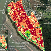 Understanding temporal and spatial variations in environmental conditions is important for determining how urban forests affect ecological communities at the local scale. This study aims to use LiDAR data to investigate how shading and cooling affect urban forests at the UBC Vancouver campus within an ecosystem services framework.
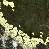 Upslope treeline advancement has been occurring globally over the last several decades, leading to displacement and fragmentation of alpine habitats and declines in species richness. Examining past and current treeline migration can provide insight into potential future conditions and can be used to improve ecosystem management. There is no long-term data on treeline advancement in Central British Columbia (B.C.) and the response to climate change is poorly understood. To address this, we explored treeline advancement in the Cariboo Natural Resource Region over a 35-year period (1985-2020) using Landsat imagery.
 Increased deforestation in British Columbia from logging practices and wildfires has led to interests from the BC Ministry of Forests, Lands, Natural Resource Operations, and Rural Development to improve reforestation efforts province-wide. Modelling cold air and frost in BC has limited research prior to this project, and unexpected frost events in Spring and Autumn can have fatal effects to young, newly-planted trees in areas where frost develops on the landscape. The frost project is part of the greater Predictive Ecosystem Mapping project for BC on behalf of the ministry, and will contribute to improved land management practices.
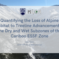 High elevation ecotones are susceptible to the rising temperature, under current climate change crisis. This paper aims to quantify the loss of alpine habitat to treeline advancement in the mountainous areas of the Cariboo Natural Resource Region. Specifically, this study focuses on comparing the patterns and rate of treeline advancement in the dry and wet subzones of Englemann Spruce – Subalpine Fir (ESSF) zone. Landsat 5 imageries and Digital Elevation Models are used to determine the treeline during 1985 – 2010.
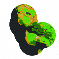 The world’s mangroves forests are a critical resource to coastal communities, providing a plethora of ecosystem goods and services to millions of local peoples, while also being among the most carbon dense and biodiverse ecosystems in the world. To develop conservation initiatives local communities and NGO’s need a framework for determining priority conservation areas that accounts for anthropogenic pressure and carbon stocks, while also reflecting the values of local peoples. Here I document a method for determining priority conservation areas using a suitability analysis combining data sources on surrounding forest loss (Global Forest Change Database), mangrove loss (Global Mangrove Watch), soil carbon content (Global Mangrove Soil Database), and above ground biomass (Global Mangrove Above Ground Biomass Database) that was applied to 96 of Blue Ventures (BV) global locally managed marine areas.
 For fire managers and industry professionals, monitoring and leading wildfire prevention efforts as well as reactionary efforts require accurate and operable fuel type maps to achieve effective management. Fuel type map classification accuracy has been seen to have varying values across industries and applications (> 10 %), and the consequences of these misclassifications in fuel type mapping has yet to be determined. The objective of this research was to explore the effects of mapping error on fire behavior metrics, burn probability, fire intensity, and rate of spread in the southern interior forest region of British Columbia which experiences dry weather and extreme fire conditions.
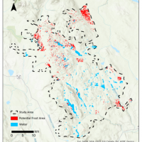 Frost, as a frequent meteorological event in Canada, can significantly impact the yield of farm crops and fruit trees, and also causes cracking of infrastructure and damage to roads and buried pipelines. Knowing the potential frost sites for the Deception Lake Study Area in northern BC is important for studying forest loss and developing reforestation plans. The Moderate Imaging Spectrometer (MODIS) night-time land surface temperature (LST) products (spatial resolution: 1 km by 1 km) from the spring (March – May) and autumn (September – November) months between 2019 and 2021 were used for extracting temperature-related frost-risk variables, including minimum temperature, mean temperature, probability of frost occurrence, frost duration and frost severity index. K-means clustering was applied to cluster each variable into high-risk areas and low-risk areas, and four clusters were issued making pixels with 4 as the highest frost-risk pixels and 1 as the lowest risk.
 To better manage green spaces in the face of climate change, the Social Ecological Economic Development Studies program of the University of British Columbia (UBC) organized a series of projects to predict the climate suitability of common tree species at Vancouver campus by 2100. Coniferous trees are vulnerable to changing precipitation and temperature. Western hemlock (Tsuga heterophylla) is a common coniferous tree species at UBC Vancouver campus and was chosen to be analyzed in this study. Climate suitability analysis was done using a MaxEnt model. As a machine-learning algorithm not requiring data about absent points, MaxEnt is considered to be a good tool for predicting the distribution of species. There were 19 bioclimatic variables tested in the analysis, and the precipitation in the coldest quarter of the year was determined to be the most important climatic variable affecting the growth of Western hemlock. The results showed that the occurrence probability of Western hemlock would drop from its current ~87% to ~10% under one of the most likely climate models in 2100. Although this result could not represent the real occurrence probability of Western hemlock by the end of the century due to the limited data and variables considered, this study provided a reference for future climate suitability analysis for other tree species and could potentially help with the protection of existing Western hemlock on campus.
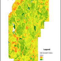 Old-growth forests have complex structures that provide critical habitat for endangered species and enhance biodiversity and ecosystem services. Old-growth forests have become rare due to harvesting. In order to support the recovery process of old-growth forests in British Columbia, it is valuable to identify old-growth characteristics in recovering forests for conservation purposes. This study attempted to predict the distribution of old-growth attributes in the Coastal Western Hemlock (CWH) zone in British Columbia using area-based LiDAR metrics. LiDAR point clouds of 61 forestry inventory plots were extracted to generate LiDAR metrics to create multilinear regression models for four old-growth attributes: standard deviation of diameter at breast height (DBH), maximum tree DBH, average live crown percentage, and the sum of understory plants percentage. The results showed the ability of LiDAR to predict varied by old-growth attributes and were highest for the standard deviation of DBH, followed by Maximum Tree DBH, the Sum of understory plants percentage and lowest for average live crown percentage. An old-growth index was derived from four old-growth attributes for mapping the potential locations of old-growth. However, the validation results of 19.08% from vegetation resource inventory (VRI) illustrate that the old-growth index does not successfully identify old growth. Despite the challenges, the prediction results can still be used to identify old-growth attributes and enhance knowledge of old-growth landscapes. Also, this study has potential applications in old-growth forest restoration and supports government’s old-growth management plans.
 In response to the growing concerns about mangrove deforestation, recent studies have used various remote sensing technology to measure the mangrove extent. In this work, we investigated the mangrove distribution in Northwestern Madagascar by using fine spatial imagery with a pixel size as small as 3m and compared it with the result of the traditional method based on relatively coarser Landsat data. The quantitative result central to this work is the new multi-date map of the Tsimipaika- Ampasindava-Ambaro Bays (TAB) from 2020 to 2022, which provides advanced detail and direct comparison with the shift in local mangrove species. The classification maps are based on Random Forest and Maximum Likelihood algorithms, and all of them have an overall accuracy of over 85%. The dynamics of mangrove forests from 2020 to 2022 are quantified, with a 12.6% loss in closed-canopy mangroves, and a 24.1% loss in open-canopy mangroves. Limitations regarding the classification model include the overestimation of open canopy mangroves caused by the shadow and the seamline in the base map. This result shows the potential of using fine-resolution satellite imagery in supervised land cover classification, and the corresponding challenges raised by the smaller pixel size.
 The landscapes in the Rocky Mountain Cordillera undergo constant change due to the intricate interplay of ecological processes, with fire being the primary disturbance agent. Fire suppression policies have impeded the ecological role of fire, resulting in increased conifer forest dominance and declines in landscape heterogeneity. The objective of this study was to develop a methodology to accurately measure regional landscape changes resulting from fire suppression and fire restoration in Banff National Park, with the goal of supporting data-informed resource management. A landscape metrics approach was selected to investigate changes across 27 management units. Four landscape metrics were calculated using annual land cover maps derived from Virtual Land Cover Engine/Landsat-5/7 imagery spanning 34 years (1984-2019). Metrics were selected to capture conifer encroachment (proportion of conifer class) and landscape heterogeneity (contagion, edge density, Shannon’s diversity index) changes. Time-series analysis and Thiel-Sen slope estimation were used to identify metric trends. The study’s resulting metrics offer resource managers additional landscape attributes to compare and monitor management units, which can support decision-making, prioritize fire restoration and inform future ecological studies.
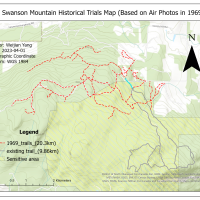 In response to growing concerns about the limited accessibility and preservation of historical trails at Rose Swanson Mountain, this study uses aerial photos and GIS to digitize these trails. Our goal is to create a comprehensive and accurate digital map of the trails while examining the impact of logging and forest fires on their length and location. The results indicate that the total length of the trails in Rose Swanson Mountain has significantly decreased due to logging activities and regulations set by the BC Ministry of Forestry. Additionally, we found that most of the existing trails are located within a sensitive area. Our study also highlighted the limitations of using aerial photography for digitizing historical trails, including the difficulty of identifying trails from air photos and the accuracy of the georeferencing process. The digital map of the historical trails can significantly contribute to the preservation of local indigenous culture and promote sustainable forest management practices that consider both economic benefits and ecological benefits. Our findings can guide policymakers in assessing the impact of logging on forests near Canadian indigenous traditional community areas and implementing regulations to mitigate these effects. Future studies can explore the benefits of preserving the forest and historical trails, such as the forest’s carbon storage potential and the economic contribution of the trail system to the local economy.
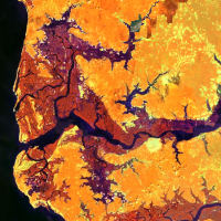 Mangrove forests are highly productive, complex coastal ecosystems that shelter a diverse range of species and offer important ecological services. In recent decades, mangrove forests in Africa have been experiencing drastic degradation and decline in population due to heavy anthropogenic pressures and climate change-induced sea level rise. To ensure the future long-term well-being of these unique ecosystems, and to reflect past conservation efforts, quantitative analysis of the past and current mangrove forest condition on a regional scale is much needed. This study systematically mapped mangrove forests along the Lower Casamance River region, using Google Earth Engine Mangrove Mapping Methodology (GEEMMM), for the years 1990 and 2021. Overall, we achieve a validation accuracy of 87.13% for the 2021 classification and 90.25% for the 1990 classification. Our study found that, across our study regions, there was a net loss of 123.99 km2 in our open-canopy mangrove I class and a net gain of 63.04 km2 in our closed-canopy mangrove class. This suggested that while some areas had seen a slight increase in mangrove populations either due to natural regeneration or ongoing conservation efforts, the overall mangrove forests had experienced major degradation. Furthermore, the majority of the loss happened within 10km of the shoreline, suggesting that fishing activity might be one of the biggest contributors to mangrove forest loss.
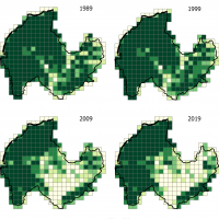 Provincial parks of British Columbia are protected for their high ecological, cultural, and recreational values. With climate change exacerbating, more frequent and severe disturbances are anticipated to cause land cover alteration in park ecosystems, leading to loss of habitat and ecosystem services. It’s crucial to understand how landscape configurations changed in the past to make informed conservation efforts. Using the landscapemetrics package in R, this project quantitatively analyzed the landscape configuration of forests and shrubs on 1 km by 1 km grids in a time step of decades from 1989 to 2019 for E. C. Manning Park, Mount Robson Park, Tweedsmuir Park, and West Arm Park. The metrics were tested to compare and characterize grids along the park boundary versus the interior. The metrics highlighted the spatial distribution and shape complexity of forests and shrubs and the time frames during which noticeable land cover changes occurred. The results provided spatial, temporal, and statistical insight into landscape dynamics over the decades. They showed that future park management could benefit from accounting for the spatial variation of the park landscape by developing targeted restoration strategies.
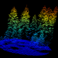 Livestock forage availability is an important factor when allocating land for grazing animals. Due to the variation in British Columbia’s topography and plant communities, rangeland management faces unique challenges with natural resource operations and rural development. The goal of this study was to create a predictive model of forage availability using light detection and ranging (LiDAR) data from the Open LiDAR Data Portal and biometric ground truthing data from the Vegetation Resource Index.
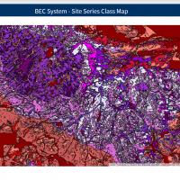 Biogeoclimatic Ecosystem Classification (BEC) system is the ecosystem classification adopted in the forest management within British Columbia based on vegetation, soil, and climate characteristics whereas Site Series is the smallest unit of the system. The Ministry of Forests, Lands, Natural Resource Operations and Rural Development held under the Government of British Columbia (“the Ministry”) developed a web-based tool known as BEC Map for maintaining and sharing the information of the BEC system, but the Site Series information was not included in the tool due to its quantity and complexity. In order to allow users to explore and interact with the information, this project aimed to develop a web-based tool with high data quality and flexibility to users for the Site Series classes using the “Shiny” and “Leaflet” packages in R.
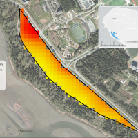 Climate change is a key factor in how extreme weather events affect how ecosystems and species react to these changes in temperatures. University of British Columbia’s (UBC) Botanical Garden is interested in improving microclimate information within the garden to understand how areas with shade create respite zones for species. Due to the recent extreme weather temperatures in Vancouver, the garden is interested in how to continue to adapt and mitigate to these extremes. Microclimates are important as they are cooler temperatures beneath the canopy. Looking at how canopy cover influences land surface temperature can give insight on microclimates. Using LiDAR metrics to calculate canopy cover and Landsat to calculate land surface temperature, a model was built to understand the significance of canopy cover and land surface temperature, with the addition of other LiDAR metrics.
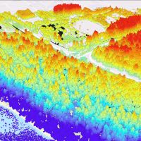 Urban trees play an essential role in alleviating the local effects of global warming by sequestering atmospheric carbon dioxide, regulating temperature and reducing air pollution in urban areas. There have been studies estimating carbon sequestration of urban trees using Light Detection and Ranging (LiDAR). Yet, neither of the studies made comparison between species nor extended the discussion towards ecosystem services. Therefore, this study compared the attributes between native and cultivated trees in the Asian Garden of the University of British Columbia (UBC) Botanical Garden, estimated their level of above-ground carbon sequestration, and thus examined respective implications in terms of ecosystem services.
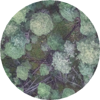 Snags (dead standing trees) form an important structural aspect of a forest and perform many essential ecological functions such as habitat provision. As such, substantial research has investigated various methods of snag detection using lidar. One approach is to compute areal lidar metrics such as slope, elevation, canopy height, etc. to detect snags. However, it remains unclear which lidar metrics are best suited for snag detection. This study attempted to predict snag presence/absence and density in the Interior Douglas-Fir (IDF) zone in British Columbia using area based lidar metrics.
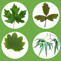 As anthropogenic climate change continues to disrupt forests and species’ ecological niches, there is increasing urgency to create plans surrounding adaptation and mitigation for especially vulnerable species. The University of British Columbia’s Botanical Garden (UBCBG) wants to understand species responses to climate change and whether species within their collection will be able to survive in the Garden, given the effects of climate change. One especially important collection UBCBG curates is maple (Acer) trees, currently leading the global consortium of Acer and housing over 50 different species. This study examined the survival probability of four Acer species UBCBG curates including: five-fingered Maple (Acer pentaphyllum Diels), considered critically endangered; paperbark/bloodbark Maple (Acer griseum (Franch.) Pax), considered endangered; bigleaf maple (Acer macrophyllum Pursh), not endangered; and vine maple (Acer circinatum Pursh), not endangered.
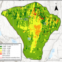 It has been long known that wildfire and harvesting can have a relationship. However, this relationship is not straightforward and well understood. In this paper, we hope to quantify the impact of proposed harvesting on the wildfire severity and probability on Rose Swanson Mountain. Rose Swanson Mountain is a small mountain in South Central BC near the town of Armstrong used by the locals for its bountiful outdoor recreation. In early 2020 British Columbia Timber Sales added part of the Rose Swanson Mountain Sensitive Area to its list of soon-to-be harvested areas. This paper illustrates the research done in BurnP3 and ArcPro to simulate and measure fire in a pre and post logged Rose Swanson.
 Standing dead trees (snags) are crucial habitats for fauna in mature and diverse forests along the Interior Douglas-fir Zone of British Columbia. The objective of this study is to evaluate whether snag density and snag metrics differ between three categories of at-risk and irreplaceable Old Growth Priority Deferral Areas (ancient, big-treed and remnant) and their neighbouring areas with no deferral status. Using airborne LiDAR data, we detect snags using 1) area-based forest metrics paired with random forest modelling, and 2) an individual snag detection algorithm.
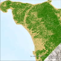 Tropical forests experience some of the highest rates of deforestation in the world. Accurate mapping and monitoring of the forest is required to mitigate this deforestation, which is complicated in tropical forests due to the high frequency of cloud cover. Synthetic aperture radar (SAR) imagery can overcome this challenge by seeing through the clouds. However, the historical lack of freely available SAR imagery means its role in characterizing forest cover is less developed than that of optical imagery. This study aimed to compare freely available SAR imagery with freely available optical imagery in order to characterize the forest cover of a particularly cloudy, mountainous tropical forest in the Philippines.
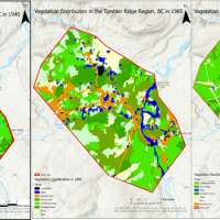 In recent years, the application of remote sensing technology in vegetation change monitoring has played an important role. The purpose of this project is to explore changes in vegetation in the Tumbler Ridge region of British Columbia between the 1940s and 2020 and to discuss the relationship to fire urbanization and deforestation. A series of aerial photographs (taken in the 1940s), Landsat 5 remote sensing images (1985), and forest vegetation composite polygons (2020) were classified and analyzed by Object-Based Image Analysis (OBIA) and Support Vector Machines (SVM) for evaluation Vegetation Composition and Matrix Analysis of Vegetation Change in the Tumbler Ridge Region Using Vegetation Transition Matrix.
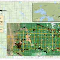 Traditionally, Light Detection and Ranging (LiDAR) was used for forest structure analysis rather than capturing spectral information. A variety of studies were conducted to investigate the spectral characteristics of multispectral LiDAR but relatively few ones have integrated it with Landsat imageries. To compare their recorded reflectance and explore the prediction potential, we evaluated two series of regression modules measuring forest reflected energy with Landsat-derived reflectance and multispectral LiDAR-derived intensity, collected over 85 plots with the same area of 1000 m2 in Petawawa Research Forest, Ontario.
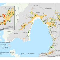 Mangrove forests are productive and biologically complex ecosystems that provide a wide range of environmental services and supply people with numerous goods. Growing in a variety of depths of salty water, mangrove forests play a significant role in supporting the coastal communities along Cambodia’s 440 kilometer-long coastline. However, mangrove forests in Cambodia have experienced great losses due to the impacts of intensive human activities. Although the human-driven mangrove losses in Cambodia have declined, the recent coverage change of mangrove forests needs to be evaluated for implementing effective regional ecological restoration programs.
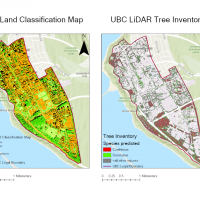 As urban forest provides ecological, social, and economic values to the residents, forest inventory can monitor forest health. Based on the land classification map, the campus planning team pays attention to tree health in the public green space of the University of British Columbia (UBC) campus in Vancouver, Canada. Working together, the forest inventory and land classification map are the priorities of urban planning and forest health in UBC. In order to solve the knowledge gap of no current inventory and land classification map on campus, this study aimed to update the UBC tree inventory and land classification map.
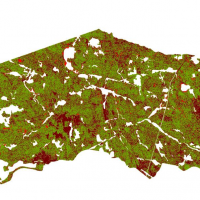 Monitoring the growth of trees is important for sustainable forest management. The traditional method of monitoring forest growth at a broad level is timber cruising by humans, while modern remote sensing technology, especially Lidar, is usually used for monitoring at the single-tree level or stand-level.
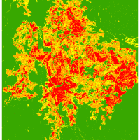 Understanding how resilient forests are after wildfire events is important to forest management practices. The objective of this study was to use Landsat-8 data to understand how the burn severity of the Little Bobtail Lake wildfire has impacted forest regrowth several years later. This was done by deriving different vegetation indices to see how the changes in vegetation health were impacted by burn severity. Additionally, landscape pattern metrics were used to understand the changes in the spatial patterns of the burn severity and vegetation health over time.
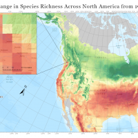 Climate change poses a considerable risk to forest diversity in urban communities. The University of British Columbia (UBC) seeks to identify vulnerable tree species on campus and apply strategies for sustaining arboreal diversity in future decades. In contribution to these efforts, this study investigated the potential shift in tree composition on the UBC Vancouver Campus over the next century by (1) predicting suitable climatic habitat for 128 campus species in 2050 and 2080, and (2) mapping the expected change in species richness across North America.
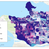 Urban vegetation acts as an extremely important carbon stock to store carbon. Although many studies have investigated the relationship between urban vegetation and carbon stocks, few of them closely examine the phenomenon of vegetation fragmentation in urban areas and how it affects the carbon stock. Therefore, this project investigates how vegetation fragmentation affects carbon stocks in the City of Vancouver using GIS analytic tools.
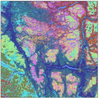 Geospatial analyses focused on quantifying fuel types fragmentation and its autocorrelation with megafire severity inform decision making in contexts such as forest management and human activities regulation. Fuel type fragmentation plays a crucial role in fire severity contribution.
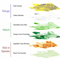 Living in cities can be stressful. While studies have shown that exposure to nature can help reduce stress and promote mental wellbeing, some research has shown that some characteristics of nature provide more psychological support than others depending on one’s state of wellbeing. City planning and urban forestry strategy need to consider the qualitative attributes of urban nature in the landscape in order to better support the different needs of the residents. This study focused on restorative nature: nature elements that help relieve stress and alleviate mental fatigue.
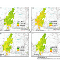 The 2017 Elephant Hill wildfire is considered as one of the most destructive fires in Canada. Wildfires are a major ecosystem disturbance which also causes residential displacement and financial loss. Monitoring vegetation recovery following wildfires becomes crucial to rebuilding the local community and ecological system.
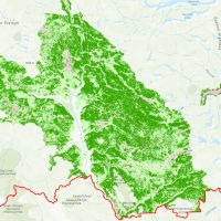 The Interior Douglas-fir zone of British Columbia’s Cariboo Region evolved alongside wildfire through millennia of repeat exposure. Resulting from these interactions were fire adapted species and landscape configurations that supported low to moderate severity wildfires. Removing the dominant disturbance agent of these dry forest ecosystems through systematic fire suppression has resulted in unforeseen repercussions. Presently, forests of the Interior Douglas-fir zone hold the potential for higher severity wildfire posing an increased threat to human life.
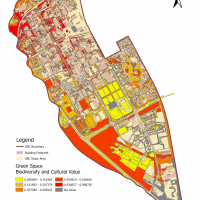 Due to the rapid growth of urbanization, species biodiversity is threatened and the innate relationship between humans and nature begins to fade gradually. Urban green spaces play a vital role in reconnecting human and urbanized landscape with its unique characteristics. Meanwhile, virtual gaming technology with applied geographic information has made a spectacular process to promote interactions between humans and their surroundings.
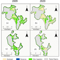 Mangrove forests, and other coastal ecosystems, are recognized for their role in climate change mitigation due to their significant potential for carbon storage and carbon sequestration. These ecosystems are some of the most threatened ecosystems on earth and are at risk of loss and degradation because of anthropogenic activities. Carbon financing mechanisms offer a way to help implement, finance and support the conservation and restoration of coastal ecosystems.