- Mapping the potential loss and migration of mangroves in Northwest Madagascar due to sea level rise
Abstract Madagascar’s mangroves comprise 2% of the world’s total, but are at risk of loss due to increasing sea level rise (SLR). Vertical elevation gain (VEC) via sediment accumulation has historically allowed mangroves to adjust to SLR, but currently in many parts of the world, SLR is outpacing VEC. This study focuses on the Ambanja-Ambaro…
Read more: Mapping the potential loss and migration of mangroves in Northwest Madagascar due to sea level rise
- Predictive Ecosystem Mapping of the Chinchaga Watershed Management Basin, North Eastern British Columbia
Abstract The purpose of this project was to identify and map the location of wetlands in the Chinchaga Watershed Management Basin within the Fort St. John Timber Supply Area. The Chinchaga study area covers 75,000 hectares (ha), and serves as an ecologically significant unit within the Fort St. John Timber Supply Area, representing the gentle,…
Read more: Predictive Ecosystem Mapping of the Chinchaga Watershed Management Basin, North Eastern British Columbia
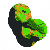
- Determining conservation priority areas for mangrove conservation and quantifying mangrove dynamics
The world’s mangroves forests are a critical resource to coastal communities, providing a plethora of ecosystem goods and services to millions of local peoples, while also being among the most carbon dense and biodiverse ecosystems in the world. To develop conservation initiatives local communities and NGO’s need a framework for determining priority conservation areas that accounts for anthropogenic pressure and carbon stocks, while also reflecting the values of local peoples. Here I document a method for determining priority conservation areas using a suitability analysis combining data sources on surrounding forest loss (Global Forest Change Database), mangrove loss (Global Mangrove Watch), soil carbon content (Global Mangrove Soil Database), and above ground biomass (Global Mangrove Above Ground Biomass Database) that was applied to 96 of Blue Ventures (BV) global locally managed marine areas.
- Within-Ecosystem Quantification and Comparison of Treeline Advancement in Cariboo Mountain, British Columbia
High elevation ecotones are susceptible to the rising temperature, under current climate change crisis. This paper aims to quantify the loss of alpine habitat to treeline advancement in the mountainous areas of the Cariboo Natural Resource Region. Specifically, this study focuses on comparing the patterns and rate of treeline advancement in the dry and wet subzones of Englemann Spruce – Subalpine Fir (ESSF) zone. Landsat 5 imageries and Digital Elevation Models are used to determine the treeline during 1985 – 2010.
- Quantifying Upslope Treeline Advancement in the Mountainous Areas of the Cariboo Natural Resource Region, British Columbia, from 1985 to 2020
Upslope treeline advancement has been occurring globally over the last several decades, leading to displacement and fragmentation of alpine habitats and declines in species richness. Examining past and current treeline migration can provide insight into potential future conditions and can be used to improve ecosystem management. There is no long-term data on treeline advancement in Central British Columbia (B.C.) and the response to climate change is poorly understood. To address this, we explored treeline advancement in the Cariboo Natural Resource Region over a 35-year period (1985-2020) using Landsat imagery.
- Predicting Frost-Prone and Cold Air Accumulation Sites from DEMs
Increased deforestation in British Columbia from logging practices and wildfires has led to interests from the BC Ministry of Forests, Lands, Natural Resource Operations, and Rural Development to improve reforestation efforts province-wide. Modelling cold air and frost in BC has limited research prior to this project, and unexpected frost events in Spring and Autumn can have fatal effects to young, newly-planted trees in areas where frost develops on the landscape. The frost project is part of the greater Predictive Ecosystem Mapping project for BC on behalf of the ministry, and will contribute to improved land management practices.
- Developing a satellite-based frost risk model for the Northern British Columbia
Frost, as a frequent meteorological event in Canada, can significantly impact the yield of farm crops and fruit trees, and also causes cracking of infrastructure and damage to roads and buried pipelines. Knowing the potential frost sites for the Deception Lake Study Area in northern BC is important for studying forest loss and developing reforestation plans. The Moderate Imaging Spectrometer (MODIS) night-time land surface temperature (LST) products (spatial resolution: 1 km by 1 km) from the spring (March – May) and autumn (September – November) months between 2019 and 2021 were used for extracting temperature-related frost-risk variables, including minimum temperature, mean temperature, probability of frost occurrence, frost duration and frost severity index. K-means clustering was applied to cluster each variable into high-risk areas and low-risk areas, and four clusters were issued making pixels with 4 as the highest frost-risk pixels and 1 as the lowest risk.
- Estimating Above-Ground Biomass Using Remote Sensing and Machine Learning in Kwahu South, Ghana
Abstract Tropical forests in regions like Kwahu South, Ghana, are vital for mitigating climate change by storing carbon in aboveground biomass (AGB), but deforestation and land use changes, driven by agriculture and mining, threaten their role as carbon sinks. Accurate AGB estimation is crucial for conservation and sustainable land management, yet traditional field methods are…
Read more: Estimating Above-Ground Biomass Using Remote Sensing and Machine Learning in Kwahu South, Ghana
- Modeling Climate Resilient Planting Locations of Culturally Significant Plants for Musqueam on the University of British Columbia’s Vancouver Campus
Abstract Urban greenspaces provide essential ecosystem services, enhance biodiversity, and hold cultural significance, particularly for Indigenous communities. However, these areas are increasingly threatened by climate change, urbanization, and invasive species. While greenspace planning and species distribution modeling are established tools for supporting ecological resilience, few studies integrate future climate suitability into site-specific planting guidelines. This…
Read more: Modeling Climate Resilient Planting Locations of Culturally Significant Plants for Musqueam on the University of British Columbia’s Vancouver Campus
- Replication Data for: Evaluating Carbon Baselines in Kwahu South: A Comparison of VM0047 and Open Forest Protocol
Abstract Forests are essential for climate change mitigation, acting as carbon sinks by absorbing carbon dioxide. Remote sensing, particularly through Landsat 8’s 30m resolution imagery, facilitates consistent, large-scale monitoring of forest cover and biomass changes, crucial for precise carbon stock assessments in reforestation efforts. However, differences in baseline estimation methodologies complicate these evaluations. This study…
Read more: Replication Data for: Evaluating Carbon Baselines in Kwahu South: A Comparison of VM0047 and Open Forest Protocol
- Climate adaptation scenarios for a resilient future at University of British Columbia Botanical Garden: Modeling 4 Species of Acer (Maple)
Abstract As anthropogenic climate change continues to disrupt forests and species’ ecological niches, there is increasing urgency to create plans surrounding adaptation and mitigation for especially vulnerable species. The University of British Columbia’s Botanical Garden (UBCBG) wants to understand species responses to climate change and whether species within their collection will be able to survive…
Read more: Climate adaptation scenarios for a resilient future at University of British Columbia Botanical Garden: Modeling 4 Species of Acer (Maple)
- Distribution of Berries in response to climate change
Abstract Climate change and greenhouse gas emissions are among the most serious issues worldwide, significantly impacting biodiversity and food security. In Canada, berries such as the Saskatoon berry and Red Huckleberry hold considerable cultural, economic, and ecological value. This study evaluates the potential impact of climate change on the future distribution of these two berry…
Read more: Distribution of Berries in response to climate change
- Comparing the Impact of Hurricane Rai on Two Mangrove Forests in the Philippines
Abstract Mangrove ecosystems are vital to coastal communities by providing a variety of crucial ecosystem services including the providing of fish stocks, building materials and firewood; the storing of large amounts of carbon; and the sheltering of coastal communities from tropical storms. For many decades, human activities have led to the degradation of these mangrove…
Read more: Comparing the Impact of Hurricane Rai on Two Mangrove Forests in the Philippines
- A Climate Suitability Analysis for Western Hemlock: Modeling Future Occurrence Probability of Tsuga heterophylla at the UBC Vancouver Campus
To better manage green spaces in the face of climate change, the Social Ecological Economic Development Studies program of the University of British Columbia (UBC) organized a series of projects to predict the climate suitability of common tree species at Vancouver campus by 2100. Coniferous trees are vulnerable to changing precipitation and temperature. Western hemlock (Tsuga heterophylla) is a common coniferous tree species at UBC Vancouver campus and was chosen to be analyzed in this study. Climate suitability analysis was done using a MaxEnt model. As a machine-learning algorithm not requiring data about absent points, MaxEnt is considered to be a good tool for predicting the distribution of species. There were 19 bioclimatic variables tested in the analysis, and the precipitation in the coldest quarter of the year was determined to be the most important climatic variable affecting the growth of Western hemlock. The results showed that the occurrence probability of Western hemlock would drop from its current ~87% to ~10% under one of the most likely climate models in 2100. Although this result could not represent the real occurrence probability of Western hemlock by the end of the century due to the limited data and variables considered, this study provided a reference for future climate suitability analysis for other tree species and could potentially help with the protection of existing Western hemlock on campus.
- Climate adaptation scenarios for a resilient future at University of British Columbia Botanical Garden: Modeling 4 Species of Acer (Maple)
As anthropogenic climate change continues to disrupt forests and species’ ecological niches, there is increasing urgency to create plans surrounding adaptation and mitigation for especially vulnerable species. The University of British Columbia’s Botanical Garden (UBCBG) wants to understand species responses to climate change and whether species within their collection will be able to survive in the Garden, given the effects of climate change. One especially important collection UBCBG curates is maple (Acer) trees, currently leading the global consortium of Acer and housing over 50 different species. This study examined the survival probability of four Acer species UBCBG curates including: five-fingered Maple (Acer pentaphyllum Diels), considered critically endangered; paperbark/bloodbark Maple (Acer griseum (Franch.) Pax), considered endangered; bigleaf maple (Acer macrophyllum Pursh), not endangered; and vine maple (Acer circinatum Pursh), not endangered.
- Using SAR Imagery to Assess Forest Distribution on a Cloudy Tropical Island
Tropical forests experience some of the highest rates of deforestation in the world. Accurate mapping and monitoring of the forest is required to mitigate this deforestation, which is complicated in tropical forests due to the high frequency of cloud cover. Synthetic aperture radar (SAR) imagery can overcome this challenge by seeing through the clouds. However, the historical lack of freely available SAR imagery means its role in characterizing forest cover is less developed than that of optical imagery. This study aimed to compare freely available SAR imagery with freely available optical imagery in order to characterize the forest cover of a particularly cloudy, mountainous tropical forest in the Philippines.
- Land Surface Temperature Anomalies and Fire Occurrence
Wildfires can disrupt forest ecosystem, leading to a deterioration of the air quality, and loss of resources, property animals and people. Understanding the driving factors and the spatial distribution of wildfire benefits local forest fire management planning and resource allocation for fire suppression. To analyze how the land surface temperature (LST) anomaly is related to fire frequency, a fire dataset including more than 400 fires occurred in Cariboo region and a daily LST anomaly dataset based on historical MODIS observations were gathered and processed.
- Fire Occurrences and Land Surface Temperature Anomalies
Victoria, Australia has suffered from forest fire for a long period, and forest cover account for almost 25% of land cover. Therefore, it is significant to control fire events especially predict the fire burning effectively. Land surface temperature (LST) anomaly, as an important index, may build a relationship with fire occurrences to help fire management.
- Modelling the Potential Impacts of Climate Change on Arboreal Diversity of the University of British Columbia Vancouver Campus from 2050 to 2080
Climate change poses a considerable risk to forest diversity in urban communities. The University of British Columbia (UBC) seeks to identify vulnerable tree species on campus and apply strategies for sustaining arboreal diversity in future decades. In contribution to these efforts, this study investigated the potential shift in tree composition on the UBC Vancouver Campus over the next century by (1) predicting suitable climatic habitat for 128 campus species in 2050 and 2080, and (2) mapping the expected change in species richness across North America.
 The world’s mangroves forests are a critical resource to coastal communities, providing a plethora of ecosystem goods and services to millions of local peoples, while also being among the most carbon dense and biodiverse ecosystems in the world. To develop conservation initiatives local communities and NGO’s need a framework for determining priority conservation areas that accounts for anthropogenic pressure and carbon stocks, while also reflecting the values of local peoples. Here I document a method for determining priority conservation areas using a suitability analysis combining data sources on surrounding forest loss (Global Forest Change Database), mangrove loss (Global Mangrove Watch), soil carbon content (Global Mangrove Soil Database), and above ground biomass (Global Mangrove Above Ground Biomass Database) that was applied to 96 of Blue Ventures (BV) global locally managed marine areas.
 High elevation ecotones are susceptible to the rising temperature, under current climate change crisis. This paper aims to quantify the loss of alpine habitat to treeline advancement in the mountainous areas of the Cariboo Natural Resource Region. Specifically, this study focuses on comparing the patterns and rate of treeline advancement in the dry and wet subzones of Englemann Spruce – Subalpine Fir (ESSF) zone. Landsat 5 imageries and Digital Elevation Models are used to determine the treeline during 1985 – 2010.
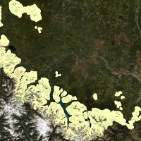 Upslope treeline advancement has been occurring globally over the last several decades, leading to displacement and fragmentation of alpine habitats and declines in species richness. Examining past and current treeline migration can provide insight into potential future conditions and can be used to improve ecosystem management. There is no long-term data on treeline advancement in Central British Columbia (B.C.) and the response to climate change is poorly understood. To address this, we explored treeline advancement in the Cariboo Natural Resource Region over a 35-year period (1985-2020) using Landsat imagery.
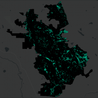 Increased deforestation in British Columbia from logging practices and wildfires has led to interests from the BC Ministry of Forests, Lands, Natural Resource Operations, and Rural Development to improve reforestation efforts province-wide. Modelling cold air and frost in BC has limited research prior to this project, and unexpected frost events in Spring and Autumn can have fatal effects to young, newly-planted trees in areas where frost develops on the landscape. The frost project is part of the greater Predictive Ecosystem Mapping project for BC on behalf of the ministry, and will contribute to improved land management practices.
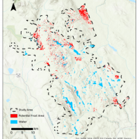 Frost, as a frequent meteorological event in Canada, can significantly impact the yield of farm crops and fruit trees, and also causes cracking of infrastructure and damage to roads and buried pipelines. Knowing the potential frost sites for the Deception Lake Study Area in northern BC is important for studying forest loss and developing reforestation plans. The Moderate Imaging Spectrometer (MODIS) night-time land surface temperature (LST) products (spatial resolution: 1 km by 1 km) from the spring (March – May) and autumn (September – November) months between 2019 and 2021 were used for extracting temperature-related frost-risk variables, including minimum temperature, mean temperature, probability of frost occurrence, frost duration and frost severity index. K-means clustering was applied to cluster each variable into high-risk areas and low-risk areas, and four clusters were issued making pixels with 4 as the highest frost-risk pixels and 1 as the lowest risk.
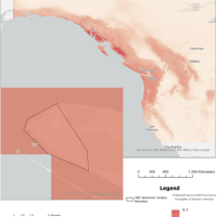 To better manage green spaces in the face of climate change, the Social Ecological Economic Development Studies program of the University of British Columbia (UBC) organized a series of projects to predict the climate suitability of common tree species at Vancouver campus by 2100. Coniferous trees are vulnerable to changing precipitation and temperature. Western hemlock (Tsuga heterophylla) is a common coniferous tree species at UBC Vancouver campus and was chosen to be analyzed in this study. Climate suitability analysis was done using a MaxEnt model. As a machine-learning algorithm not requiring data about absent points, MaxEnt is considered to be a good tool for predicting the distribution of species. There were 19 bioclimatic variables tested in the analysis, and the precipitation in the coldest quarter of the year was determined to be the most important climatic variable affecting the growth of Western hemlock. The results showed that the occurrence probability of Western hemlock would drop from its current ~87% to ~10% under one of the most likely climate models in 2100. Although this result could not represent the real occurrence probability of Western hemlock by the end of the century due to the limited data and variables considered, this study provided a reference for future climate suitability analysis for other tree species and could potentially help with the protection of existing Western hemlock on campus.
 As anthropogenic climate change continues to disrupt forests and species’ ecological niches, there is increasing urgency to create plans surrounding adaptation and mitigation for especially vulnerable species. The University of British Columbia’s Botanical Garden (UBCBG) wants to understand species responses to climate change and whether species within their collection will be able to survive in the Garden, given the effects of climate change. One especially important collection UBCBG curates is maple (Acer) trees, currently leading the global consortium of Acer and housing over 50 different species. This study examined the survival probability of four Acer species UBCBG curates including: five-fingered Maple (Acer pentaphyllum Diels), considered critically endangered; paperbark/bloodbark Maple (Acer griseum (Franch.) Pax), considered endangered; bigleaf maple (Acer macrophyllum Pursh), not endangered; and vine maple (Acer circinatum Pursh), not endangered.
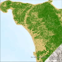 Tropical forests experience some of the highest rates of deforestation in the world. Accurate mapping and monitoring of the forest is required to mitigate this deforestation, which is complicated in tropical forests due to the high frequency of cloud cover. Synthetic aperture radar (SAR) imagery can overcome this challenge by seeing through the clouds. However, the historical lack of freely available SAR imagery means its role in characterizing forest cover is less developed than that of optical imagery. This study aimed to compare freely available SAR imagery with freely available optical imagery in order to characterize the forest cover of a particularly cloudy, mountainous tropical forest in the Philippines.
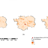 Wildfires can disrupt forest ecosystem, leading to a deterioration of the air quality, and loss of resources, property animals and people. Understanding the driving factors and the spatial distribution of wildfire benefits local forest fire management planning and resource allocation for fire suppression. To analyze how the land surface temperature (LST) anomaly is related to fire frequency, a fire dataset including more than 400 fires occurred in Cariboo region and a daily LST anomaly dataset based on historical MODIS observations were gathered and processed.
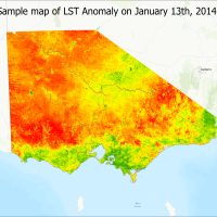 Victoria, Australia has suffered from forest fire for a long period, and forest cover account for almost 25% of land cover. Therefore, it is significant to control fire events especially predict the fire burning effectively. Land surface temperature (LST) anomaly, as an important index, may build a relationship with fire occurrences to help fire management.
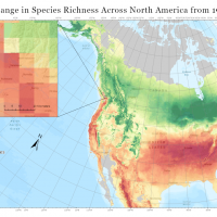 Climate change poses a considerable risk to forest diversity in urban communities. The University of British Columbia (UBC) seeks to identify vulnerable tree species on campus and apply strategies for sustaining arboreal diversity in future decades. In contribution to these efforts, this study investigated the potential shift in tree composition on the UBC Vancouver Campus over the next century by (1) predicting suitable climatic habitat for 128 campus species in 2050 and 2080, and (2) mapping the expected change in species richness across North America.