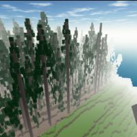
- Using LiDAR Data to Analyze the Habitat Suitability for Birds and Create the Minetest Digital Twin Model of UBC Botanical Garden
This project aims to guide the University of British Columbia Botanical Garden to create Bird-friendly green spaces by using LiDAR data to analyze and map UBCBG’s bird habitat suitability and create a 3D digital twin model of UBCBG in the open source game engine Minetest to increase 3D visualization and aid in landscape planning. By extracting the Canopy Height Model (CHM) and performing individual tree segmentation, the derived metrics were used to identify trees with the highest bird habitat suitability index. This study is highly relevant for landscape adaptation and planning in conjunction with other management considerations to support bird-friendly green spaces. The digital twin model can be used for educational and promotional purposes and landscape planning and aesthetic design with the consideration of bird conservation.
- Exploring the Potential of 3D Game Engines for Precise and Detailed Geo-Visualization in Forestry Education
In response to the growing concern in geographic information science, which pertains to utilizing contemporary internet technology to communicate past information or knowledge for establishing foundations in geography. Recent studies have investigated geomatics solutions for historical city, and enhancing GIS skills through collaborative approach. This study built upon prior research by exploring how the implementation of current technology can promote a cooperative learning environment, particularly within the realm of forestry education. Minetest, the 3D voxel game engine has high capability of modification, for visualizing natural environments and urban structures. The goal of this study was to investigate the potential of using the game engine for forestry education purposes. We developed precise and detailed models of building structures and their surrounding environment. We also explored the visualization beyond 3D geospatial data, by generating analytical results of solar radiation on building roofs using GIS software. The visualization process was facilitated by the use of 3D light detection and ranging (LiDAR) data, provided by the UBC Campus + Community Planning department. The proposed approach proved to be effective in producing compatible geospatial data for visualization in the game engine. We also conducted exploratory statistical analysis to examine the relationship between building energy usage and solar radiation. The exploratory regression result indicates its insignificant impact on building energy usage. Finally, the research findings provide a foundation for future studies that can continue to explore the potential of using 3D game engines.
- Predicting Forage Availability from Open Source LiDAR Data
Livestock forage availability is an important factor when allocating land for grazing animals. Due to the variation in British Columbia’s topography and plant communities, rangeland management faces unique challenges with natural resource operations and rural development. The goal of this study was to create a predictive model of forage availability using light detection and ranging (LiDAR) data from the Open LiDAR Data Portal and biometric ground truthing data from the Vegetation Resource Index.
- Understanding Microclimate in University of British Columbia’s Botanical Garden
Climate change is a key factor in how extreme weather events affect how ecosystems and species react to these changes in temperatures. University of British Columbia’s (UBC) Botanical Garden is interested in improving microclimate information within the garden to understand how areas with shade create respite zones for species. Due to the recent extreme weather temperatures in Vancouver, the garden is interested in how to continue to adapt and mitigate to these extremes. Microclimates are important as they are cooler temperatures beneath the canopy. Looking at how canopy cover influences land surface temperature can give insight on microclimates. Using LiDAR metrics to calculate canopy cover and Landsat to calculate land surface temperature, a model was built to understand the significance of canopy cover and land surface temperature, with the addition of other LiDAR metrics.
- Comparing the Level of Above-ground Carbon Sequestration and Respective Ecosystem Services between Native and Cultivated Trees in the University of British Columbia Botanical Garden
Urban trees play an essential role in alleviating the local effects of global warming by sequestering atmospheric carbon dioxide, regulating temperature and reducing air pollution in urban areas. There have been studies estimating carbon sequestration of urban trees using Light Detection and Ranging (LiDAR). Yet, neither of the studies made comparison between species nor extended the discussion towards ecosystem services. Therefore, this study compared the attributes between native and cultivated trees in the Asian Garden of the University of British Columbia (UBC) Botanical Garden, estimated their level of above-ground carbon sequestration, and thus examined respective implications in terms of ecosystem services.
- Snag Detection In The Interior Douglas-Fir Zone Of British Columbia Using Area-Based Lidar Metrics
Snags (dead standing trees) form an important structural aspect of a forest and perform many essential ecological functions such as habitat provision. As such, substantial research has investigated various methods of snag detection using lidar. One approach is to compute areal lidar metrics such as slope, elevation, canopy height, etc. to detect snags. However, it remains unclear which lidar metrics are best suited for snag detection. This study attempted to predict snag presence/absence and density in the Interior Douglas-Fir (IDF) zone in British Columbia using area based lidar metrics.
- Evaluation of snag density and snag metrics in Old Growth Deferral Priority Areas in the Cariboo region using airborne LiDAR data
Standing dead trees (snags) are crucial habitats for fauna in mature and diverse forests along the Interior Douglas-fir Zone of British Columbia. The objective of this study is to evaluate whether snag density and snag metrics differ between three categories of at-risk and irreplaceable Old Growth Priority Deferral Areas (ancient, big-treed and remnant) and their neighbouring areas with no deferral status. Using airborne LiDAR data, we detect snags using 1) area-based forest metrics paired with random forest modelling, and 2) an individual snag detection algorithm.
- Comparing Multispectral LiDAR to Landsat and Sentinel Imagery
Traditionally, Light Detection and Ranging (LiDAR) was used for forest structure analysis rather than capturing spectral information. A variety of studies were conducted to investigate the spectral characteristics of multispectral LiDAR but relatively few ones have integrated it with Landsat imageries. To compare their recorded reflectance and explore the prediction potential, we evaluated two series of regression modules measuring forest reflected energy with Landsat-derived reflectance and multispectral LiDAR-derived intensity, collected over 85 plots with the same area of 1000 m2 in Petawawa Research Forest, Ontario.
- Mapping Pollinator Habitat at UBC from LiDAR
Pollination is an essential ecosystem service for crop production, where species such as insects and birds help to transfer pollen for plants to reproduce. Many of the pollinators are fully dependent on the plants and trees as their food sources and habitat. From a perspective of an urban planner, we must be able to recognize the values brought by pollinators to our ecosystems. Thus, we are attempting to discover the relationship between species and their habitats as much as possible.
- Tree Height Growth in the Petawawa Research Forest from LiDAR
Monitoring the growth of trees is important for sustainable forest management. The traditional method of monitoring forest growth at a broad level is timber cruising by humans, while modern remote sensing technology, especially Lidar, is usually used for monitoring at the single-tree level or stand-level.
- Identifying and Categorizing Pond Types from LiDAR
The Rangeland Department in the Kamloops District from the Government of British Columbia has recently raised concerns regarding the observation on the reduction of the number and the surface area of the grassland ponds in the Lac du Bois Grasslands Protected Area. This study aims to distinguish between the ponds with stable groundwater inputs (i.e. connected ponds) and the ponds with unstable groundwater inputs (i.e. perched ponds) to assist the government in determining reliable water sources.
 This project aims to guide the University of British Columbia Botanical Garden to create Bird-friendly green spaces by using LiDAR data to analyze and map UBCBG’s bird habitat suitability and create a 3D digital twin model of UBCBG in the open source game engine Minetest to increase 3D visualization and aid in landscape planning. By extracting the Canopy Height Model (CHM) and performing individual tree segmentation, the derived metrics were used to identify trees with the highest bird habitat suitability index. This study is highly relevant for landscape adaptation and planning in conjunction with other management considerations to support bird-friendly green spaces. The digital twin model can be used for educational and promotional purposes and landscape planning and aesthetic design with the consideration of bird conservation.
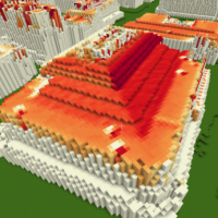 In response to the growing concern in geographic information science, which pertains to utilizing contemporary internet technology to communicate past information or knowledge for establishing foundations in geography. Recent studies have investigated geomatics solutions for historical city, and enhancing GIS skills through collaborative approach. This study built upon prior research by exploring how the implementation of current technology can promote a cooperative learning environment, particularly within the realm of forestry education. Minetest, the 3D voxel game engine has high capability of modification, for visualizing natural environments and urban structures. The goal of this study was to investigate the potential of using the game engine for forestry education purposes. We developed precise and detailed models of building structures and their surrounding environment. We also explored the visualization beyond 3D geospatial data, by generating analytical results of solar radiation on building roofs using GIS software. The visualization process was facilitated by the use of 3D light detection and ranging (LiDAR) data, provided by the UBC Campus + Community Planning department. The proposed approach proved to be effective in producing compatible geospatial data for visualization in the game engine. We also conducted exploratory statistical analysis to examine the relationship between building energy usage and solar radiation. The exploratory regression result indicates its insignificant impact on building energy usage. Finally, the research findings provide a foundation for future studies that can continue to explore the potential of using 3D game engines.
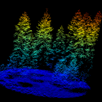 Livestock forage availability is an important factor when allocating land for grazing animals. Due to the variation in British Columbia’s topography and plant communities, rangeland management faces unique challenges with natural resource operations and rural development. The goal of this study was to create a predictive model of forage availability using light detection and ranging (LiDAR) data from the Open LiDAR Data Portal and biometric ground truthing data from the Vegetation Resource Index.
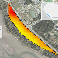 Climate change is a key factor in how extreme weather events affect how ecosystems and species react to these changes in temperatures. University of British Columbia’s (UBC) Botanical Garden is interested in improving microclimate information within the garden to understand how areas with shade create respite zones for species. Due to the recent extreme weather temperatures in Vancouver, the garden is interested in how to continue to adapt and mitigate to these extremes. Microclimates are important as they are cooler temperatures beneath the canopy. Looking at how canopy cover influences land surface temperature can give insight on microclimates. Using LiDAR metrics to calculate canopy cover and Landsat to calculate land surface temperature, a model was built to understand the significance of canopy cover and land surface temperature, with the addition of other LiDAR metrics.
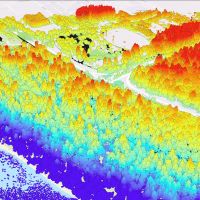 Urban trees play an essential role in alleviating the local effects of global warming by sequestering atmospheric carbon dioxide, regulating temperature and reducing air pollution in urban areas. There have been studies estimating carbon sequestration of urban trees using Light Detection and Ranging (LiDAR). Yet, neither of the studies made comparison between species nor extended the discussion towards ecosystem services. Therefore, this study compared the attributes between native and cultivated trees in the Asian Garden of the University of British Columbia (UBC) Botanical Garden, estimated their level of above-ground carbon sequestration, and thus examined respective implications in terms of ecosystem services.
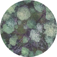 Snags (dead standing trees) form an important structural aspect of a forest and perform many essential ecological functions such as habitat provision. As such, substantial research has investigated various methods of snag detection using lidar. One approach is to compute areal lidar metrics such as slope, elevation, canopy height, etc. to detect snags. However, it remains unclear which lidar metrics are best suited for snag detection. This study attempted to predict snag presence/absence and density in the Interior Douglas-Fir (IDF) zone in British Columbia using area based lidar metrics.
 Standing dead trees (snags) are crucial habitats for fauna in mature and diverse forests along the Interior Douglas-fir Zone of British Columbia. The objective of this study is to evaluate whether snag density and snag metrics differ between three categories of at-risk and irreplaceable Old Growth Priority Deferral Areas (ancient, big-treed and remnant) and their neighbouring areas with no deferral status. Using airborne LiDAR data, we detect snags using 1) area-based forest metrics paired with random forest modelling, and 2) an individual snag detection algorithm.
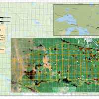 Traditionally, Light Detection and Ranging (LiDAR) was used for forest structure analysis rather than capturing spectral information. A variety of studies were conducted to investigate the spectral characteristics of multispectral LiDAR but relatively few ones have integrated it with Landsat imageries. To compare their recorded reflectance and explore the prediction potential, we evaluated two series of regression modules measuring forest reflected energy with Landsat-derived reflectance and multispectral LiDAR-derived intensity, collected over 85 plots with the same area of 1000 m2 in Petawawa Research Forest, Ontario.
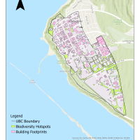 Pollination is an essential ecosystem service for crop production, where species such as insects and birds help to transfer pollen for plants to reproduce. Many of the pollinators are fully dependent on the plants and trees as their food sources and habitat. From a perspective of an urban planner, we must be able to recognize the values brought by pollinators to our ecosystems. Thus, we are attempting to discover the relationship between species and their habitats as much as possible.
 Monitoring the growth of trees is important for sustainable forest management. The traditional method of monitoring forest growth at a broad level is timber cruising by humans, while modern remote sensing technology, especially Lidar, is usually used for monitoring at the single-tree level or stand-level.
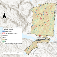 The Rangeland Department in the Kamloops District from the Government of British Columbia has recently raised concerns regarding the observation on the reduction of the number and the surface area of the grassland ponds in the Lac du Bois Grasslands Protected Area. This study aims to distinguish between the ponds with stable groundwater inputs (i.e. connected ponds) and the ponds with unstable groundwater inputs (i.e. perched ponds) to assist the government in determining reliable water sources.